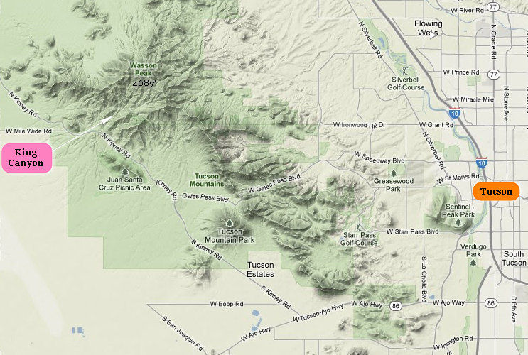
Intro: Hiking King Canyon with Betsy
In the fall of 2004 I found myself in need of a car after my HippyMobile was towed when a neighbor complained about it being parked along the road. Oh, well. It was just about shot and I was getting tired of having to crawl in and out of the window anyway.

My HippyMobile turned out to be a great work car when building an observation platform in White Park.
Another, friendlier neighbor down the road had a 1989 Plymouth Reliant sitting in the drive that had turned into an "around town" car. Knowing she also had a newer car I approached her about selling the old Reliant. After some discussion we settled on a price of $350.00.
Several months later, on a snowy January morning I drove the packed-to-the-gills car out of the driveway and headed to Tucson. This was my first solo EpicRoadTrip (ERT).

At the time my brother William (aka Yinks) was living in Tucson. It was there I stayed for several weeks enjoying the weather, scenery and food. During that time William introduced me to the joys of hiking in the Sonoran Desert. He took me on several great hikes and one of them was a wandering meander up King Canyon which was on the west side of the Tucson Mountains.
I loved that canyon with its cool geology and gorgeous desert plants. At that time there was a bit of water running in the canyon and some wild flowers in bloom. This made the hike all that much more memorable.
So, it should come as no surprise the first place I wanted to take Betsy to was King Canyon.
Fast forward to 2012
The day broke clear and was a welcome change from the previous day's hike in the clouds and snow. Fortunately for us the weather cleared the next day. It was still brisk and breezy but that would be excellent hiking weather.
Previously I mentioned to Betsy about the hike my brother William had taken me on in 2005. So, we decided to head on up that way and enjoy the sunny weather.
Here are some orientation maps:

Click on the photos below for a larger image.

This is Betsy in the King Canyon wash. Although not actually the official trail, this is how I was introduced to the Canyon in 2005 by my brother William. The official trail uses an old CCC road which is above the wash. The crisp air and bright sunshine were wonderful!

The first of many fine Prickly Pear cactus specimens we would see as we hiked through this lovely Saguaro forest.

For those not familiar with the term "wash" it refers to a dry creek bed or gulch that temporarily fills with water after a heavy rain. Some may know it by its Spanish name - Arroyo. Remember, we are in the desert, albeit a "wet" one. The only time you are likely to see running water is after the heavy monsoon rains in the summer or in the spring when the melting snow creates significant run-off.
This, coupled with the fact the water table has been dropping for decades makes running water in this area a bit of a rarity.
That was not always the case. As humans proliferated and water consumption increased the once flowing waters of major rivers like the Santa Cruz became a trickle and then disappeared altogether. The lush, diverse riparian habitat disappeared and was replaced by a dry xeric landscape.
It is estimated if the current rate of the aquifer recharge is sustained it will take over 100 years to re-water the Santa Cruz river and restore the riparian habitat.
The first people who lived in the Tucson area got their water from the Santa Cruz River or from springs that bubbled to the surface at the base of Sentinel Peak (now called “A” Mountain), Black Mountain near San Xavier Mission and several other spots. Enough water was available to satisfy the needs of a few thousand people, including irrigating crops.
In fact, Santa Cruz River water has been used to irrigate farms for at least 2,000 years. The Santa Cruz River was not a big river like the Colorado or Gila rivers, but the river did flow most of the time in the Tucson area. The Hohokam caught edible fish in the Santa Cruz, and early pioneers hunted water-loving muskrats.Source: Water Resources Research Center

This is the reason I prefer walking up the wash for the first mile rather than taking the old roadway.

Being down in the wash allows one to get up close and personal with the geology.
A major period of volcanic activity occurred in the Sonoran Desert area between 20 and 40 million years ago. There were many active volcanoes that produced large calderas (circular basins formed by volcanic explosions), lava vents, and cinder cones.
Rhyolite and basalt volcanoes characterize Sonoran Desert volcanism. The majority of the rhyolites were produced 20 to 40 million years ago, although some date back to at least 70 million years ago. Rhyolites are light-colored volcanic rocks rich in silica, aluminum, potassium, and sodium. Rhyolite volcanoes have a tendency to explode violently.
The Tucson Mountains located on the western edge of Tucson, Arizona, consist of rhyolite volcanic rock from a volcanic episode 70 million years ago.Source: National Park Service

The first, but not the last Saguaro we would see growing out of a crack in the Rhyolite.
The saguaro; scientific name Carnegiea gigantea) is a large, tree-sized cactus species in the monotypic genus Carnegiea. It is native to the Sonoran Desert in the U.S. state of Arizona, the Mexican state of Sonora, a small part of Baja California in the San Felipe Desert and an extremely small area of California, U.S. The saguaro blossom is the State Wildflower of Arizona.
The common name saguaro came into the English language through the Spanish language, originating in the O'odham language.
Saguaros have a relatively long life span. They take up to 75 years to develop a side arm. The arms themselves are grown to increase the plant's reproductive capacity (more apices lead to more flowers and fruit). The growth rate of saguaros is strongly dependent on precipitation; saguaros in drier western Arizona grow only half as fast as those in and around Tucson, Arizona.
Some specimens may live for more than 150 years; the largest known saguaro is the Champion Saguaro. It grows in Maricopa County, Arizona, and is 13.8 meters (45.3 ft) tall with a girth of 3.1 meters (10 ft). These cacti can grow anywhere from 15 to 50 feet. They grow slowly from seed, and not at all from cuttings. Whenever it rains, saguaros soak up the rainwater. The cactus will visibly expand, holding in the rainwater. It conserves the water and slowly consumes it.
Source: WikiPedia

One of the really cool things about taking the wash instead of the road is all the fun little ledges you get to climb up. Here, Betsy makes it look easy.


At Mile 1 we departed the wash and picked up the official trail. We decided to check out the old Mam-A-Gah picnic area, which was named after a Tohono O’odham Indian Chief. It was built by the CCC in the 30s. The structure shown here is one of the now closed rest rooms which were built by the CCC as well.

Very scenic spot for an out-house!

Up a short hill to a flat spot one will find the picnic area, complete with ramada.
Note the supporting posts of the Ramada. They are Saguaro skeletons which are hollow. The clever CCC boys filled them with concrete to make these sturdy posts. This is what I call good use of native materials.
These folks shown here were taking a much needed 3 hour break from their kids aged 4, 8 and 12.

This is one of the fire grills. Somehow I can't image most people hauling all the fixin's for a cook out up to this area. Maybe they used to be able drive up the old CCC road to get here.

Here, Betsy passes through "The Cholla Gate" and heads back down to the main trail.

There are lots of interesting things to see in the Sonoran desert. Here we see a Cholla skeleton at the base of a Saguaro.

The multi-stemmed upright plant in the background is an Ocotillo.

The remains of a Saguaro skeleton along with Ocotillo in the back and Palo verde on the left.

It is uncommon to see Saguaro all lined up in a row like this.
Notice none of them have "arms". Here in this region of the Sonoran desert, branches normally begin to appear when a saguaro reaches 50 to 70 years of age. In areas of lower precipitation, it may take up to 100 years before arms appear.
So, the specimens shown here are still babies.

Beauty in the desert: Betsy, Ocotillo, Barrel cactus, Saguaro, Palo verde, Beaver-tail cactus and Creosote Bush.
Notice how the trail is "trenched". This is due to the 10s of thousands of hikers walking the trail over the decades as well as water erosion during the intense "monsoon" rains which occur during the summer.

This is looking back down the canyon. The sun is getting low now and really starting to make things look interesting.

This is one of the steeper, rockier sections near the saddle which will be our turning point.

It is not often one gets to see a Saguaro root, but that is what Betsy is being supported by.

A closer look at the Saguaro root.

The Saguaro skins get pretty weird looking.

Another shot looking west back down the Canyon towards Avra Valley.
The distant rectangular "lakes" are actually recharge basins placed for the City of Tucson Water Department's Central Avra Valley Storage and Recovery Project (CAVSARP).

Aerial view of some of the recharge basins in Avra Valley.
One would think this would be great habitat and an oasis for birds. But, vegetation growth is controlled to reduce habitat for birds due to the proximity of the Marana Northwest Regional Airport.
The CAVSARP project allows Tucson Water to productively use Colorado River water as a drinking water supply through a process known as recharge and recovery. Groundwater overuse in the latter half of the 20th Century led to severely declining groundwater levels and the beginnings of subsidence (land sinking) in and around Tucson. In addition, Arizona law requires Tucson and other groundwater dependent communities to reduce reliance on this limited resource and switch to renewable supplies.
To eliminate overpumping, the City has been switching from groundwater to renewable Colorado River water delivered via the Central Arizona Project (CAP). Water quality issues that occurred when Colorado River water was first delivered to Tucson Water customers in 1992-94 led to the passage of Proposition 200, the Water Consumer Protection Act, which prevented the delivery of CAP water directly to customers.
To meet the requirements of the Act, Tucson Water developed the CAVSARP project to recharge, store and recover a blend of Colorado River water and groundwater. This allowed the City to shut down many of its groundwater wells in and around urban Tucson.Source: © 2011 City of Tucson

The Central Arizona Project canal as it snakes its way through the desert.
Source: WikiPedia
One of the unintended consequence of the Central Arizona Project was the introduction of quagga, or Zebra mussels.
'Quagga mussels could spread into Lake Pleasant, if they haven�t already. These prolific invaders pose a significant, multimillion-dollar threat to our lakes, rivers, streams and water systems,' says Larry Riley, the fisheries chief for the Arizona Game and Fish Department. Source: Lake Havasu Marina
The Central Arizona Project (CAP) is a 336 mi (541 km) diversion canal in Arizona in the United States. The aqueduct diverts water from the Colorado River from Lake Havasu City near Parker into central and southern Arizona. The CAP is the largest and most expensive aqueduct system ever constructed in the United States. CAP is managed and operated by the Central Arizona Water Conservation District (CAWCD).
Source: WikiPedia
Ok, back to the hike!

This is the saddle and junction of the King Canyon and Sweetwater Trail. The latter is accessed via the El Camino Del Cerro Road trail head.
In the distance can be seen the Catalina mountains and Tucson basin in the foreground.

It is getting late and it is time to head back down the trail. The hike to Wasson Peak will have to be for another day.
We decided to hike the old CCC road to get back down the Canyon. It winds along the opposite side of the canyon and affords some different views.

The setting sun is really starting to light things up!

The low sun is highlighting every little "tooth" on this Sotol plant.

From the old road we could look across the canyon and see the trail we had just ascended.

All the Teddy Bear cholla were starting to sparkle.

This was the last shot of the day.
We arrived back at our starting point at dusk - tired and happy. Gotta come back soon!
~~~~~~~~~~~~~~~~~~~~~~~~~~~~~~~~~~~~
Intro: Hiking with the Tucson Meet-up Hiking Group
When I arrived in Green Valley back in December one of the first things I did was contact the Green Valley Hiking club about joining.
They have 100s of members and usually have a dozen different hikes which go out each Thursday. I thought joining this group would be a good way to learn some of the local trails.
But, it was not to be. After attending their new member orientation I found out I would not be able to hike in open toed sandals - like the Chacos I now wear (not by choice, I might add).
I stayed after the orientation to get a clarification about "appropriate footwear policy". I was told some hike leaders might allow me on hikes wearing my Chacos, but it was unlikely. Rather than put up with a bunch of shit from Those Who Know Better Than I, and then be turned away from hikes I decided to forget about the Green Valley Hiking Club and look elsewhere.
That "elsewhere" ended up being the Tucson Meet-up Hiking Group.
As a solitary hiker most of the time or hiking with Betsy alone, I was surprised how much I enjoyed group hiking. So much so that I started, with the help of group leader Bill Carter, leading hikes for the group.
And, choosing my first hike to lead for the group was a no-brainer - King Canyon.
Here are a few shots I took on that hike.

The group was nicely mixed - ages ranged from the 20s to the 60s. That is one of the things I like about this hiking group.

Everyone had fun getting up and over the ledges.


Meet Jen, from Pittsburg PA. She had just moved to Tucson after finishing up some schoolwork in California and now was enrolled at U of A and working on her specialty - Natural Resources Management with GIS.
Note the sandals!!

I had been up the Canyon twice and missed the Hohokam petroglyphs.
The term Hohokam, borrowed from the Akimel O'odham, is used to define an archaeological culture that existed from the beginning of the current era to about the middle of the 15th century AD. As an abstract construct, this culture was centered on the middle Gila River and lower Salt River drainages, in what is known as the Phoenix basin. This is referred to as the Hohokam Core Area, as opposed to the Hohokam Peripheries; or adjacent regions into which the Hohokam Culture extended. Collectively, the Core and Peripheries formed what is referred to as the hoekam regional system, which occupied the northern or Upper Sonoran Desert in what is now Arizona.
Source: WikiPedia

Everyone took turns examining and photographing the ancient artwork.

"And here we have..."

On the way up we stopped at the Mam-A-Gah picnic area. Those table tops are concrete. The CCC built things to last.

The ultimate cactus experience. Alison had raised her arm to point out the trail direction and brushed against a Teddy Bear cholla. This is the reason they are sometimes referred to as "Jumping Cholla". The segments have relatively weak connections which will separate with very little disturbance.

Hmmm... What to do now?

Someone came to the rescue with two small stones and began to tug on the cholla section and off it popped.

Unfortunately it landed right on the hand of her rescuer who then underwent the removal procedure.

A short ways from the saddle we stopped to catch our breath and take in the views.
We then hiked the last bit up to the saddle and had some lunch.
From the saddle you can see Tucson and the Catalina Mountains to the east and Avra Valley, Kitt Peak and the Baboquivari Peak Wilderness to the west.

The Happy Hikers of the Tucson Hiking Meetup Group.

After lunch at the saddle we headed on down the old CCC road and then back to the cars.
So end two excellent hikes in King Canyon.
But wait - that's not all!!!!
On February 10th I led a loop hike with the Tucson Hiking Meetup Group.
We hiked up King Canyon, then to Wasson Peak and returned to the TH via the
Hugh Norris,
Sendero-Esperanza and
Gould Mine Trails to complete this loop. I had not been on these three return trails so this was a treat for me.
Hiker Roger Nordby got some great photos of this hike which can viewed at the Tucson Hiking Meetup Group web site.