Mike Breiding's Epic Road Trips ~2017~
A Quick Trip to the Rocky Mountain Region
10 Days in Wyoming, Utah and Colorado
Visits to: Knerr Ranchette, Snowy Mountains, DinoLand, Flaming Gorge, Colorado NM and the Gunnison Country
Friday, August 10th: Vernal UT to Montrose CO
An Unexpected Detour, More "Grand Landscapes of the American West"
and on to the Gunnison Country
With our departure from Vernal Utah we have turned the corner on our 10 day trip to WY, UT and CO - both literally and figuratively. Now we head south back into Colorado to revisit the Gunnison Country. But first we must take another trip in the Way Back Machine.
Way back in the Spring of 1982 Betsy and I spent part of our Honeymoon in the Canyonlands and Arches National Parks. We camped at Island in the Sky Campground and from there made several forays down to Arches NP.
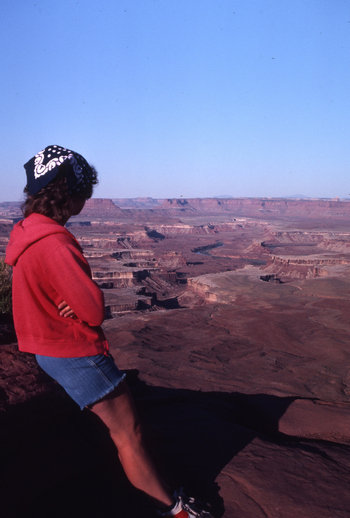
Here she is in 1982 - my child bride enjoying the view from
Island in the Sky (Willow Flat) Campground in Canyonlands NP.
As I am fond of saying: "Time flies whether you are having fun or not." And that is how one day we awoke and realized it had been 32 years since that wonderful time in Canyonlands and in all those years we had not been back once. How could this happen?
This inspired me to plan our "Return to Honeymoon Heaven". On that trip in April of 2014 we stayed at the very same campground - Island in the Sky. And, I can't swear to it, but we might have even stayed in the very same camp site!
 Campground in Canyonlands NP")
Here she is in 2014 - my Senior Hottie enjoying the view from
Island in the Sky (Willow Flat) Campground in Canyonlands NP.
Ok. To make a long story longer - in 1982 we hiked an area in Arches NP called the Devil's Garden. The big attractions on this hike are Landscape Arch and Double O Arch which are quite amazing.
Since I have a compulsion to try to repeat past experiences we also hiked the same trail on our return in 2014.
While having a snack at Double O Arch we struck up a conversation with a fella and were talking about how Betsy and I had been here some 32 years ago and how we loved the canyon country out here in Utah.
He then asked: Have you ever been to "Colorado National Monument?" To which we replied: "No".
Then he proceeded to tell us what a fantastic place it was and how we must go there someday.
This is something we have both heard over and over again and it is one of the curses of talking to a fellow hiker.
Anyway, this guy was on his way over there to volunteer for several weeks and he was looking forward to getting back there.
How does all that relate to our drive from Vernal UT to Montrose CO? The day before we left Betsy was perusing the road map we would be using for navigation. She said: "Have we been to Colorado National Monument?" So, I said "No - don't you remember when we talked about it with that guy we met at Arches". She did not remember so I recounted the encounter. Then she showed me the map. Our route would take us right by Colorado National Monument and the decision was made to stop there on the way to Montrose and have a look around. Good decision.
So we could get an earlier start than usual I decided to forego the usual 3-4 hours of Trogging. Again. Good decision.
Our route would take us east to Dinosaur CO on US 40 which makes its way all the way to Wheeling WV and beyond. That section is referred to as the "National Road". In Dinosaur we would pick up SR 64 and then just a few miles east of Rangely we would head south on SR 139 which would take us right down to Fruita and Colorado National Monument.
When we got to Dinosaur we decided to stop at the Colorado Welcome Center. The address is 101 E. Stegosaurus St in case you ever want to stop there. Once inside I was greeted by a friendly, helpful and knowledgable gentleman who supplied me with not only a map of Colorado NM but also a self guided tour brochure to the roadside petroglyphs which can be found along SR 139 south. Groovy.
We then headed east to Rangely and then proceeded south on SR 139. Betsy kept a sharp eye on the mile markers and kept referring to the brochure to see where we should stop to take a look at the petroglyphs. At some point she said. "Something isn't right, I think this brochure is screwy. These mile markers just don't make any sense.
After a while we figured out why. How did I figure this out? When I saw a sign that said "64". Shit! Both the driver and the navigator had missed the turn off to 139 and now we were way east of where we should be.
We pulled off and looked at the map to see what our options were. They were limited. So we ended up driving 50 miles out of way and then backtracking to get to Colorado NM. And, we missed all them cool petroglyphs! Grrrr...
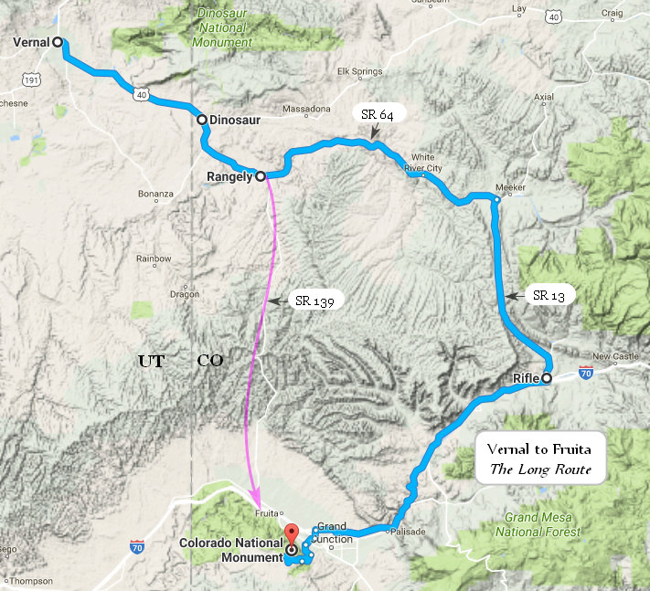
The magenta line represents the route we should have taken. Groan...
Click on the photos below for a larger image.

Getting this shot was the only thing that made our navigational screw up worthwhile. Do you suppose the person who put this up had any clue? It seems to me if they did they would have gone to any lengths to either correct it or obliterate it.
We finally got to "The Monument" around noon. As you can imagine it was getting toasty by then and there were a few people out and about.
We made a brief stop at the visitors center to get some suggestions on a hike and then it was off down the Rim Rock Drive.
Now it's time for a little background info.
Colorado National Monument (locally referred to as The Monument) is a National Park Service unit near the city of Grand Junction, Colorado. Spectacular canyons cut deep into sandstone, and even granite–gneiss–schist, rock formations. This is an area of desert land high on the Colorado Plateau, with pinion and juniper forests on the plateau.
Its feature attraction is Monument Canyon, which runs the width of the park and includes rock formations such as Independence Monument, the Kissing Couple, and Coke Ovens. The monument includes 20,500 acres (32 square miles), much of which has been recommended to Congress for designation as wilderness.
The area was first explored by John Otto, a free spirit who settled in Grand Junction in the early 20th century. Prior to Otto's arrival, many area residents believed the canyons to be inaccessible to humans. Otto began building trails on the plateau and into the canyons. As word spread about his work, the Chamber of Commerce of Grand Junction sent a delegation to investigate. The delegation returned praising both Otto's work and the scenic beauty of the wilderness area, and the local newspaper began lobbying to make it a National Park.
The area was established as Colorado National Monument on May 24, 1911. Otto was hired as the first park ranger, drawing a salary of $1 per month. For the next 16 years, he continued building and maintaining trails while living in a tent in the park.
Source: WikiPedia

As we ascended the mesa we had the first "WOW!" of many we would have on the Rim Rock Drive.

There were numerous vista points and we stopped at many of them.

Here is a look at the Visitors Center from the Rim Rock Drive.

Most of these snaps will speak for themselves.

This is called the "Kissing Couple". Someone had a good imagination.

Our first look at Independence Monument in beautiful Monument Canyon.

As you can see, Independence Monument dominates the canyon view.


Two monuments to look at here: On for geology and one for Dynamic Aging.

With each bend in the road another fabulous view presented itself.

Obviously I just could not get enough snaps of Independence Monument.


Perfect picture taking weather: bright sun, blues skies and big puffy clouds.


I have heard of "hanging valley" but not "hanging canyon". There are some similarities between the two. The sign explains it. Click and you might be able to read the description.

The hanging canyon nicely frames the city of Grand Junction.

And that concludes our tour of the Rim Rock Drive. Now it is time to find the trail head for the Serpents Trail.

I was delighted to see this sign at the trailhead. However, we have found these signs are often ignored by irresponsible dog owners who just can't stand to be separated from their "fur babies" and think the rules don't apply to them.

The trail followed an old road bed up to the Canyon Rim Drive. We did not realize the trailhead was so much lower than the mesa top. This meant it was all that much warmer.


We saw some interesting formations but the trail offered no dramatic views like we had hoped.

A look down at the current road which winds its way up to the Rim Rock Drive.

This was the most interesting formation we saw - "Nipple Peak".
We made our way back up the Serpent trail and then exited the Monument via the east entrance. Although a hurried visit, it certainly gave us a good taste of the area. The next time we visit I hope we can hike more of the trails and spend more time poking about.
When we got down to Grand Junction we had no idea how to get on US 50 which would take us the 60 miles to Montrose.
I pulled off into a parking lot and Betsy went in to get directions from a local. While I sat there in the van it dawned on me - this is one of the reasons we got smart phones!
So, while she got verbal directions I got digital ones. Good thing. When Betsy got back to the car she said she could barely understand the directions she was given by the shop keeper. "No Worries". We just listened to Miss GoogleMaps and before we knew it we were on US 50 and on our way to Montrose where we would spend the next two nights.

As you can see from the above map there is much to do in this area and one could easily spend a week exploring it.
When we arrived in Montrose we checked in to the Briarwood Inns. This is one of those $45.00 hotels that charges $70.00. The place was OK but in need of some sprucing up and general upgrading. The proprietor did a have a decent breakfast selection. Not just the usual cheap breakfast bars and cheerios.
One good thing about the place and one of the reasons I chose it - we could walk to the Horsefly Brewing Company in about 5 minutes. And we did just that.

When we walked into the Horsefly Brewing we were surprised to see the place full up - including the bar. Fortunately there was a large outdoor seating area and before you know it we each had a pint of Red in front of us.

To help us drink the beer we ordered some "Southwest Chicken Egg Rolls:
Filled with smoked chicken, black beans, corn, jalapeños, Jack cheese,
red peppers and spinach Served with Sriracha ranch. 5.99".
They were different and we liked them.
We ordered our dinner and I ordered a second pint. We now generally split dinners in order to keep both the cost and calories down. Betsy's choice tonight and she ordered the:
"Mushroom Swiss Burger
Topped with fresh sauteed mushrooms and melted Swiss cheese 9.99"
I don't know about you but I figger any burger that costs 10 bucks ought to be big enough to split into two decent size portions. This one was not. The patty size looked like something you would get at Hardees and the fixins were slim. By the time it was divided it looked more like a snack portion than a meal.
We took our time with the meal and beers. It was pleasant sitting outside and by now the traffic had thinned out a bit.
When we got back to the hotel we finalized our plans for tomorrow's hike on the north side of the Black Canyon of the Gunnison.
And then to bed.
Saturday, August 11th: Black Canyon of the Gunnison
Hiking the Vista Trail on the North Rim
Betsy and I have been to the Black Canyon of the Gunnison twice before: once on our Honeymoon in May of 1982 and again in June of 1997. Both times we hiked a trail down into the canyon. That trail was very steep and there were cables along the more dicey parts so you could both hold on while descending and pull yourself up while ascending. This trail was on the north side of the rim where we set up camp both times.
When planning todays hike I put my vote in for hiking the canyon trail once again. Betsy was not too keen on this. I think she had a more vivid memory of just how steep and dicey it was. Anyway, she said perhaps we should find a hike on the north side of the rim since we had never been up there. I resisted at first but finally saw the wisdom in her suggestion. I am inclined to try to repeat past experiences and this does not always allow for seeing new places.
And, as I was to find out, the trail we took down into the canyon twice before no longer exists. At least according to the NPS.
"There are no maintained or marked trails into the inner canyon. Routes are difficult to follow, and only individuals in excellent physical condition should attempt these hikes."
The above quote is from the Hiking the Inner Canyon on the NPS Gunnison web site. When we visited in 1982 and 1997 the area was a National Monument. It is now a National Park and some changes have been made. One of the changes is controlling the use of the Canyon Backcountry by requiring use permits and no longer maintaining old trails or listing them as "hiking" trails. What remains of the original canyon trail is now a backcountry route only.
One downside to hiking any trails on the north rim was the distance we would have to drive from Montrose where we were staying. I estimated it would take about an hour and a half and it was every minute of that. In order to beat the heat on this hike we decided to get an early start. So early in fact if we ate breakfast in Montrose my stomach would already be growling by the time we got to the trailhead. Knowing this we decided to try to find some place to eat in Delta CO which we drove through on the way to Montrose and we would be driving through again on our way to the North Rim. So while driving through Delta the first time, Betsy used her phone to Google some eateries we drove by and find out the phone numbers. None of them she called would be open when we wanted breakfast. However, one of them suggested we check with the Sundance Restaurant at the Days Inn. Betsy looked up their number, called them and indeed they would be open at 6:00am. Bingo!

This would be our route today. We arrived at 6:30 for breakfast in Delta and were at the trailhead (North Rim Ranger Station) about 8:30. Our return to Montrose would take us back via SR 92 and US 50.
But, before we hit the trail let's fire up the WayBack Machine again and see where it takes us.
Here we are - transported back to 1982.
Betsy is shown below enjoying a Gunnison river chilled Coors beer (aka Colorado Kool-Aid) with two fellas who had back packed into the canyon and were in the process of getting ready to pack out.

Thursday, May 20th 1982
We broke camp early and set up camp again in the upper campground, and at 10:15 we set off for the bottom of the canyon.
The path down was steep! At one point a chain was stretched between the trees to help people descend.
The views were magnificent.The hike up was really rugged! It took us two hours, with many rest stops. I found 5 tics on me! Luckily none attached. Our new bird for the day was the green tailed towhee. We saw hummingbirds but couldn't get a good enough look to ID. Beautiful weather!
At the bottom we met two guys who were camping and fishing and they offered to share the 14" brown and rainbow trout they'd just caught. So they took them right out of the river, gutted them and cooked them on a grill over the fire. They were great!
Source: The Honeymoon Journal of Betsy Beal Breiding

Here are the trout Betsy mentions above in her journal.
That is the Gunnison River in the background.
OK, let's shut down the WayBack machine for now and get Back to the Future!

When we hit the trail it was sunny, cool and quiet. Our hike today would be a total of 7.5 miles which would be the out and back distance to the summit of Green Mountain and the out and back distance to Exclamation Point.
Note the placard with the red slash through it. It clearly states "No Pets". We would find out later some dog owners are liars and some are arrogant jerks.

Here we are with our first peek of the Canyon.

This gaping maw looks into a canyon which is narrow, steep and deep. In fact at its deepest it is almost 3000 feet from rim to river.

The forest we would hike through today is considered a "pygmy forest" and consists primarily of Gambel oak, Pinyon pine and Utah juniper.
The Gambel Oak has adapted to form dense thickets without the need for seed germination. Read on...
Tuber-like roots called lignotubers cause the deciduous Gambel oak (Quercus gambelii) to form dense thickets. This unique feature is embedded in the trunk beneath the bark and just below the soil. A swollen lignotuber houses hundreds of buds ready to transform into leafy sprouts. Underground stems called rhizomes also bear dormant buds ready to sprout after fires or heavy browsing by wildlife.
Oak acorns take a year to mature. Being rich in carbohydrates, fats and proteins, they are on top of the wildlife food list.
Source: NPS
A lignotuber is a woody swelling of the root crown possessed by some plants as a protection against destruction of the plant stem, such as by fire. The crown contains buds from which new stems may sprout, as well as stores of starch that can support a period of growth in the absence of photosynthesis. The term "lignotuber" was coined in 1924 by Australian botanist Leslie R. Kerr.
Many plants with lignotubers grow in a shrubby habit, but with multiple stems arising from the lignotuber. The term lignotuberous shrub is used to describe this habit.
Source: WikiPedia

Trees grow very slowly in this dry rocky habitat. This Utah juniper could have easily been over 100 years old at the time of its death.

There were several places along the trail which had short spurs out to the canyon's edge. Unlike the south rim there were few places with views directly into the depths of the canyon.

Here we are at Exclamation Point. It provides a nice place to sit and enjoy the canyon view and listen to the distant roaring of the Gunnison River.

This was the only shot I could get down to river level. As is often said: "You had to be there...".
After chatting a bit with the couple above and taking in the view, we strolled back to the North Vista Trail. We had only hiked a few minutes when here comes two 20 somethings - with a dog. Whenever I encounter this I always stop in my tracks and wait until the dog owners either pull in their dogs close or move off the trail. These folks moved off the trail.
A that point I politely informed them dogs were not permitted on this trail. The young woman said:" Oh, we talked to the ranger and he said it was OK". My first instinct was to say; "Bull shit". Instead I said: I am really surprised to hear that because the ranger has no such authority". Again she stated they were told it was "OK".
Betsy and I moved on and saw no one else until we reached the summit.

The closer we got to the summit the larger the Junipers got and the sparser the oaks got. We saw some mighty fine specimens of the Utah Juniper.

Near the summit we had some nice views of the San Juan Mountains to the south.

Here is a nice colony of Brittle prickly pear (Opuntia fragilis). The common name alludes to the easily detached stem segments which aid in dispersal.

Here is another little taste of the canyon. Note the haze. Just about everywhere we went on this trip it seemed hazy.

Our lunch spot was on a stone bench in the shade of a large Utah juniper. By now it was getting a tad warm and we were glad for the shade.
After a leisurely lunch we started back down the trail. It was not long before we started seeing other hikers heading up the trail. When we saw them it made us glad we had gotten an early start and avoided most of the heat.
As we were heading down the trail and rounding a bend we met the ranger I had talked with at the contact station before we started our hike.
I told him about the women who said she had been given permission to hike with her dog. He said that was not true and he had done no such thing. So she had boldly lied to us about this. Why? What was the point?
It turns out the ranger was up patrolling the trail because there had been complaints about dogs on the trail. We told him the one we saw had been several hours ago and they were long off the trail by now.
We chatted a bit more and it turned out the ranger was a newly minted structural geology graduate student from WVU in Morgantown and he had just recently arrived to start work here at BCGNP.
Betsy and I knew many of the folks in the Geology Department he mentioned. Small world...
After inviting him to come and see us in Tucson we parted ways - he up the trail and we down.
At some point on the trail I heard someone coming up towards us. When I looked up I saw a 20 something woman hard charging up the trail with two dogs. Her entourage of three young men followed closely.
Seeing there was no stopping them, Betsy and I stepped off the trail to let them pass. As they did I said: "Hi folks, did you know dogs are not allowed on this trail?" To which doggie lady replied: "Oh, I have done a good bit of research on that actually". WTF ????!!!!
I then informed her there was a ranger just up the trail and I was sure he would want to talk to her about that. She said something about how she would talk to him and with that they were up the trail and out of sight.
One has to wonder if the two violators we encountered today have given any thought to what a bad impression their behavior makes and how it casts a poor light on responsible dog owners who obey the rules. Apparently they do not care.

I just had to get one more Juniper shot before we got off the trail. That concludes our hike on the North Rim of the Black Canyon of the Gunnison. It was a nice hike but the views were not nearly as dramatic as those which can be seen on the south rim.
Our route back to Montrose would take us along the south rim of the canyon. We stopped at several view points but I took no snaps. There were several trails which went down into the canyon as well. Perhaps another time.
When we arrived back at the hotel in Montrose we set about reorganizing and packing for the last leg of our trip. Tomorrow we would drive back to Denver and check into a Motel 6 on the east side.
Sunday and Monday, August 12 and 13th
Montrose to Denver: Lots of Scenery and lots of Traffic

Our scenic route back to Denver. We could have backtracked to Grand Junction and picked up I-70 but we opted for a route which would be a little slower and more interesting.

Whenever I think of Colorado I think of mountains. And mountains it does have. But it also has square miles of plateau, mesa and valley lands. Most of the latter are ag lands.
When thinking about colorful Colorado, outdoor adventure and the Rocky Mountains usually spring to mind. However, nearly half of the state’s 66 million acres are dedicated just to farms and ranches. Home to towering mountains and flat plains, soils in Colorado’s eastern regions and valley of the western mountains are some of the most fertile in the nation. It is no wonder that the agricultural sector contributes more than $40 billion to the state’s economy each year and provides more than 173,000 jobs.
Cattle and calves, corn, wheat, hay and dairy dominate as the Centennial State’s leading agricultural commodities. Colorado is as diverse in commodities as in geography, with producers raising bison, ostriches and emu, and growing sunflowers, grapes and mushrooms, among others.
Source: © 2017 Journal Communications


This is not our first stop at Monarch Pass. We came through this way in late May of 1982 on our Honeymoon. At that time there were towering piles of snow in this parking lot.

The drive was indeed scenic and we saw more than one peak with leftover snow.

Our route took us right by the Climax mine at Frémont Pass.
The Climax mine, located in Climax, Colorado, United States, is a major molybdenum mine in Lake and Summit counties, Colorado. Shipments from the mine began in 1915. At its highest output, the Climax mine was the largest molybdenum mine in the world, and for many years it supplied three-fourths of the world's supply of molybdenum.
Historically, mining was principally by "sub-level induced panel caving", a method that removes ore by undercutting the base of a panel in the ore deposit, causing the rock above to break and drop down in a controlled manner. The method allowed economical extraction of the large low-grade ore deposit. Current mining operations at Climax are via an open-pit.
Source: WikiPedia
Our route would also take us through Leadville, another mining area where significant quantities of both silver and gold ore were mined.
Leadville is the highest incorporated city in the U.S. We had planned to stop and look around but all the other tourists who got there before us had filled up the parking areas and clotted the sidewalks with shoppers and gawkers.
We eventually arrived at Wheeler Junction, home to Copper Mountain which is a ski resort about 75 miles west of Denver. Betsy had been here skiing when she was a grad student (MLS) at Denver.
This is where we would pick up I-70 for the rest of the drive into Denver and our motel.
We gassed up and walked around a bit. There were several bike paths going east and west and a fair amount of people out and about. We saw more nice wild flowers and I took a few snaps.

There was lots of Rocky Mountain penstemon (Penstemon strictus) in bloom.

As with other areas we visited on this trip I saw a number of plants I was not familiar with.

This was shot from the pedestrian bridge which spans Ten Mile Creek at Wheeler Junction. Betsy told me when she was in grad school she and some of her buddies would come up this way in the summer and lay out along the creek to sunbathe.

The wild flowers in this area looked like they had been planted as part of the reclamation and landscaping during the construction of the bike path.

One final shot before we got on the road.

When we merged onto I-70 east this is what we saw - for the next 89 miles. It was "slow and go". That is what the info signs along the road called it.
When we got to Denver, traffic was at a near standstill from heavy storms which had rolled through and had flooded some sections of the interstate. Lots of fun.
We got checked into the motel which was a bit dumpy, had beer and munchies and then walked over to Denny's to get take out spaghetti and meatballs. Normally I would not be caught dead eating at a Denny's but I could not face driving anywhere once we got settled in. While we were waiting for our take out a women came in with a GrubHub delivery bag. She was there to pick up 3 junk food desserts. Yuk.
The next morning we were able to make our way to Enterprise and drop off the car. While I checked in the car Betsy ordered an Uber car which arrived in only minutes. Yippee!
While she and the driver loaded our luggage I told the Enterprise employee about the brake and tire problems the car had and she knocked a day off the total. That made the full amount for 10 days $180.00. Compare that to the 371.00 it would have cost at the airport! That made the hassles we had worth it.
Our Uber driver, Raynier, was friendly and professional and got us to the airport in short order.
We once again had been given TSA pre check status through security and we were at our gate in short order. We were both hungry now and knew we would need to fuel up for the flight home. Of course there were numerous places to eat at the gate and based on the menu selection we chose Modern Market.
We each had a sandwich and they were quite tasty and filling. I thought they were a good value for the money considering the location.
Mike:
BACON* 6.75
All natural, nitrate free bacon, cage free
eggs & provolone on ciabatta
Cal 521 · Fat 29g · Carbs 36g · Protein 29g · Fiber 2g
Betsy:
EGG + CHEESE* 6.15
Cage free eggs & provolone on ciabatta
Cal 419 · Fat 20g · Carbs 36g · Protein 23g · Fiber 2g
We then parked ourselves at the gate and settled in for the 2 hour wait for our flight. Betsy read and I did my Trog thing which Betsy snapped a picture of.

Our 3.5 hour flight to Pittsburg seemed like an eternity. Upon landing we collected our luggage and then started the trek to the car. I don't think I could have parked any further from the terminal than I did.
It was warm and humid and the short trudge to the car with the luggage plum wore us out.
Fortunately the drive home to Wheeling is an easy one with no interstates and before you know it we were back on the front porch enjoying our delayed Happy Hour.
And that, as they say, is that!
Until next time...
~Mike and Betsy
![]()
![]()
Begin Again