Mike Breiding's Epic Road Trips ~2017~
A Quick Trip to the Rocky Mountain Region
10 Days in Wyoming, Utah and Colorado
Visits to: Knerr Ranchette, Snowy Mountains, DinoLand, Flaming Gorge, the Gunnison Country
Tuesday, August 8th
Moving On: Laramie to Vernal UT
We were up around 6:00 and it was another cool morning in the Snowy Mountains in the Medicine Bow National Forest. This morning we would have no warming fire in the wood stove as this was the morning we would depart the cabin and make our way west to Vernal UT.
We bundled up and took our coffee out to the front porch. All was quiet. Very quiet. As we sat there silently there was a movement to our left - an bull elk moved silently into the meadow in front of the cabin and grazed peacefully. It changed direction and came directly toward the front porch. It came in close and didn't seem to see us at all. We stayed very quiet and did not move.
The elk wandered a bit toward the lake, still grazing. Then, with quick movement it raised its head and stared directly at the lake. I was watching the elk intently, Betsy was not. Then she whispered: "Mike, look, down by the lake". I shifted my gaze from the elk to the lake and there I saw what Betsy was talking about - a bull moose with a large rack grazing on the willow along the lake shore.
The moose raised its head and their gazes locked. Slowly the moose moved toward the cabin. Slowly the elk moved as well, occasionally looking up and locking in on the moose. Then, more movement to our left and another, much larger bull elk appeared and joined the other one. The both stared intensely in the direction of the moose. Then, shortly thereafter they moved off and disappeared into the woods.
In the meantime the moose made its way through the lake side meadow, occasionally grazing. Betsy and I watched in amazement as it got closer and closer. Then it crossed the lane to the cabin. How close was it going to get!? Not seeming to notice us at all it wandered along the lane then changed direction, ambled up the hill and was gone.
Betsy and I turned and looked at each other. Neither of us could believe our luck in seeing not only two elk, but a moose at close range! What a way to start the day.
Oh, and by the way, our trio of Grey Jays who had been coming in on food forays, came for a morning visit as well.
We finished our coffee and then it was down to the business of packing and cleaning the cabin. Then we were off to Centennial for breakfast at the Friendly Store.
Click on the photos below for a larger image.

One final shot of Brooklyn Lake before we headed off the mountain.

I mentioned earlier about the millions of trees which were killed by the mountain pine beetle epidemic. Aside from the immeasurable environmental damage and loss from this deforestation there are human safety issues as well. Many trees which are now dead standing are in close proximity to roads, utility lines and structures. The trees have to be removed to help prevent damage when they eventually come done.
That is what is going on here. Dead standing trees within a certain distance from the road are being felled and then hauled off by log trucks.

Shortly after I took this picture there were numerous log trucks and traffic control vehicles coming in. Now is a good time to be leaving as I am sure there will be nothing but the sound of heavy equipment and chain saws to be heard all day and for many days to come.
On the drive from Centennial to Laramie our wildlife viewing continued. We saw (unfortunately) a dead coyote, some mule deer and Prong horn antelope.
I forgot to mention - on our first night at Scott and Jen's place just south of Laramie a herd of prong horn ran along side of the house and I saw them from the dining room table. I shouted out and jumped up for a better look. Meanwhile Claire dashed out to the deck for a better look and counted 9 antelope.
On the way down SR 130 to Laramie we also spotted several of the ubiquitous Black-billed magpies. Betsy and I first encountered these birds back in 1982 while on our Honeymoon. They are big showy birds and are always a treat to see.
The black-billed magpie (Pica hudsonia), also known as the American magpie, is a bird in the crow family that inhabits the western half of North America, from Colorado, to southern coastal Alaska to northern California, northern Nevada, northern Arizona, northern New Mexico, central Kansas, and Nebraska. It is black and white, with black areas on the wings and tail showing iridescent hints of blue or blue-green. It is one of only four North American songbirds whose tail makes up half or more of the total body length (the others being the yellow-billed magpie, the scissor-tailed flycatcher, and the fork-tailed flycatcher).
This species prefers generally open habitats with clumps of trees. It can therefore be found in farmlands and suburban areas, where it comes into regular contact with people. Where persecuted it becomes very wary, but otherwise it is fairly tolerant of human presence. Historically associated with bison herds, it now lands on the back of cattle to clean ticks and insects from them. Large predators such as wolves are commonly followed by black-billed magpies, who scavenge from their kills. The species also walks on the ground, where it obtains such food items as beetles, grasshoppers, worms, and small rodents.
Source: WikiPedia

We had pre arranged with Scott to meet him at the intersection of SR 130 and 230 on the west side of Laramie. Now the loaners - bedding, cooler and such were returned and final farewells said and then it was on down SR 230 for us and back to work for Scott.
Ok. Time for the Way Back Machine to get crankin'.
Back in June of 1997 Betsy and I were on a road trip from Morgantown to the western states. This included exploring downtown Denver and visiting with a friend in Golden, CO.
Below is a snippet from Betsy's journal for that time frame.
6-18-97
We reorganized the car & left Denise's (in Golden) about 10:00 a.m. First we went to King Sooper for groceries (which included a package of sushi from the deli) then we gassed up & headed north. Although we had originally planned to stay in Rocky Mountain National Park or the surrounding forest service area, we ended up going farther north & crossing into Wyoming and Medicine Bow National Forest.
We stopped at Boswell Creek Camp Ground & decided that was the place for us. Eight lovely, wooded, widely spaced campsites. We chose one from which you could hear the burbling of the creek & set up camp. Only one other site was occupied that night.Not long after we were set up it began to rain & hail, so we retreated to the car with beer & wine. When we realized it was not going to let up in the near future, we decided to take a drive. We took a gravel/dirt road that hooked up to 230 in 7 miles. In several places, the road became a red, wet clay/powder surface which was almost impossible to drive on. We inched along, trying not to slide off the road & breathed a sigh of relief when we reached the hard top. Since it was still pouring rain, we decided to stop and have our supper at the Woods Landing Bar & Café. It was quite a quaint old place, with some local characters and a dance floor supported by box car springs! We talked with the older man next to us at the bar as we ate.
We got back to the camp ground shortly after 8:00, had a lovely quiet fire & went to bed.
P.S. There were lots of mosquitoes!!
From the Journal of Betsy Breiding
Finding that Campground and stumbling upon Woods Landing Bar & Café in 1997 was quite the memorable experience.
I have thought about that wonderful stay many times over the years and I had always hoped we would return some day. Betsy did not, but I did - in 2011.
Here is my account of that visit: Sentimental Journey: Woods Landing and Boswell Creek Campground.
Since Betsy was not on that solo road trip I decided we would plan our route to revisit both the Woods Landing Bar & Café and Boswell Creek Campground.

It was through these doors Betsy and I first wandered back in 1997. Now, Betsy returns for the first time in 20 years.

A new sign had been erected telling about the history of place.
The architecture of the Woods Landing Dance Hall reflects the Scandinavian heritage of the area. Typical of Scandinavian construction, this log hall exhibits peeled and rounded logs with stepped and notched corners. Chinking was not necessary between each log, as the logs were hand hewn to fit together tightly. The foundation consists of rocks gathered from the nearby Laramie River.
The oak dance floor, supported with 24 boxcar springs, has been a popular attraction with lumberjacks, cowboys, and students from the University of Wyoming. The springs add bounce, which is ideal for square dancing or folk dances that are done in unison to a specific rhythm. Designed and constructed by Hokon (also spelled Hokun or Hokum), Lestrum, the dance hall was completed in 1932 for Clarence and Mayme Lewellen. Mayme wanted a resort where vacationers could come to the mountains to relax. Several cabins were constructed but later razed. In 1936, Clarence Lewellen died, and two years later Mayme married Hokon Lestrum. When Hokon died of cancer in 1971, Mayme continued to operate the lodge and used the hall for auctions to raise funds for such causes as cancer research. In 1988, at the age of 90, Mayme passed away, bringing an end to the original ownership.The community of Woods Landing was established in the 1880s by Mr. Samuel S. Wood (1841-1901), who operated sawmills located near this site. Mr. Wood supplied ties to the Union Pacific Railroad. Wood himself owned and operated a saloon near this location to serve tie-hacks and travelers who stopped here when Woods Landing was a station along the Laramie-North Park Stage Route.

Click on the photo to better read the sign.
While staying at Boswell Creek Campground we went for a hike on a nearby trail. It was on that hike in 1997 that I found one of the few pieces of clothing that I actually cherish.

And here is that piece of clothing.
The trail we were on was a designated Cross country ski trail and here is the hat someone lost back 20 years ago. It was hand made and fortunately made for someone with a small head.
Note the tassel, when I first found it along side the trail covered in mud and twigs the tassel was much fuller. But twenty years of hard use has taken its toll.
OK, time to move on. Next stop, Boswell Creek Campground so it was down the road we went.

The scenery is beautiful along this stretch of road. The Little Laramie River wanders through this valley and there are lots of ranches that have been here many years along the waters edge.

It was quiet and peaceful here in the valley.

This fella did not move quite quickly enough. This is a red shafted flicker, the first of many we would see and hear on this trip. We have the yellow shafted flicker back home in West Virginia.
The red-shafted and yellow-shafted forms of the Northern Flicker formerly were considered different species. The two forms hybridize extensively in a wide zone from Alaska to the panhandle of Texas. A hybrid often has some traits from each of the two forms and some traits that are intermediate between them. The Red-shafted Flicker also hybridizes with the Gilded Flicker, but less frequently.
Source: © 2015 Cornell University
We now turned off onto the road that would take us to Boswell Creek Campground - or so I thought. When I was here in 2011 I had no trouble driving directly to the Boswell Creek Campground. Today would be different.
I drove just far enough to think I had missed the turn off so we took the next US Forest Service road we came to in case that was it. It was quite a pretty drive but not the right road for the campground.

I hopped out to take a snap of this old barn. It was made out of hewn logs.
We drove and drove and drove and finally hit a roadblock.

We sat in the car for about 15 minutes while these two cow hands tried to move the heard several hundred feet and through a gated fence opening.

It was rather comical to watch and the guy shown here was obviously getting frustrated and pissed off as the cattle moved back and forth and back and forth across the road but not toward the fence opening.

By now he was cussin' and hollering at the cattle. Then his buddy showed up and they finally got the cattle moved through the gate and the gate closed. During all this Betsy had seen a sign on the gate and read it with the help of her binocs. It said: "Private Property". Not good.
We had hit a dead end on this road and so we turned around. As we passed the cowboys I greeted them and told them where we were trying to go and that I figgered I was on the wrong road. They agreed. I asked them if they had any idea of the where abouts of "the old Boswell Creek Campground". They grunted "No". Not too friendly.

On the way back to the main road (SR 10) I took another snap of the old barn.

There were not too many rock outcrops on this drive so I snapped a pic of this one.
When we got back to the main road I finally got around to looking at the map. It was then I realized I had way overshot our road to Boswell Creek Campground and we were now deep into Colorado. What to do? Betsy and I looked at the map and made the decision to continue south to SR 14 and then take that over to US 40 which was our route to Vernal UT.

Quite the detour, wouldn't you say? I was disappointed about not getting Betsy back to Boswell Creek Campground and could only hope there would be another time.

Here is a terrain image view of the area of our unintentional Scenic Route. You can see the route took us through about 50 miles of valley all of which appeared to be ranched and grazed. We saw at least one "Dude Ranch" with some Asians with helmets on riding horses and 3 decked out coy boys leading them on a ride.
We continued on down the valley enjoying the scenery and thankful the dirt road was in excellent condition.

Now here is something you don't see everyday - a Bald Eagle sitting on a fence post. Quite the surprise.


Much of the road went through open range. We saw mostly cattle but there were a few horses milling about as well.

The snow on the distant range is still feeding all the creeks and rivers.

We came across this beautiful grove of Trembling Aspen (Populus tremuloides) that flanked both sides of the road.


Water in the west has a bloody history. There have been lives lost and fortunes made.

Here is some history of this water tunnel.
The Laramie-Poudre Tunnel is an early transmountain tunnel in the U.S. state of Colorado. The tunnel transfers water from the west side of the Laramie River basin, which drains to the North Platte River, to the east side Cache la Poudre River basin that drains to the South Platte River. The tunnel is about 11,500 feet (3,500 m) long with variable diameters with a minimum diameter of about 5.3 feet (1.6 m). The diameter varied due to the different material mined through and the erosion of almost 90 years of water flow. It is located at about 8,400 feet (2,600 m) elevation with about a 1.7 degree down slope. The Laramie River lies about 225 feet (69 m) higher than the Cache La Poudre River at this location separated only by a mountain ridge. The Laramie-Poudre Tunnel is located about 45 miles (72 km) west-northwest of Fort Collins, Colorado, about 20 miles (32 km) south of the Wyoming border and about 25 miles (40 km) north of Rocky Mountain National Park. It was built between 1909 and 1911 to convey water from the Laramie River to the Poudre River for Front Range irrigation. Court battles between Colorado and Wyoming over water rights prevented operation until 1914 (Case 1995).
Source: WikiPedia

Here is our full route for the day. It was about a 7 hour drive. Another route which would have been quicker would have been to hop on I-80 at Laramie, drive west to Rock Springs and pick up US 191 south to Vernal. However, I think we took the right route. Do you?
We arrived in Vernal UT around 5:30 and checked into the Sage Motel. We picked the Sage because they had rooms far back from the road and it was within walking distant of eateries and groceries.
We got unloaded and settled into the room and then decided it was time for Happy Hour. Actually, it was loooooooooong overdue!

Our Happy Hour at the Vernal Brewing Company.
Tomorrow we step back in time - WAY back!
Wednesday, August 8th
Vernal, UT: Exploring DinoLand
Betsy and I have been to Utah a number times. The first time was 35 years ago in 1982 while on our Honeymoon. But, we have never been up in this corner of the state. Now we are, and we have some places to explore while we are here.

Here are some maps for orientation.

Map of Utah with Dinosaur NM and Flaming Gorge areas highlighted.

As you can see Dinosaur NM straddles two states - Utah and Colorado. Utah is home to the Carnegie Quarry and the world famous "Wall of Bones".
In Colorado the Canyon unit is the gateway to the monument's mountains and river canyons and back country.
Of course like most of you all I have heard about The Land of the Dinosaurs before but I was short on background information and history on this area made famous by the excavation of Dinosaur fossils. So, once again - WikiPedia to the rescue!
The dinosaur fossil beds (at Dinosaur NM) (bone beds) were discovered in 1909 by Earl Douglass, a paleontologist working and collecting for the Carnegie Museum of Natural History. He and his crews excavated thousands of fossils and shipped them back to the museum in Pittsburgh, Pennsylvania for study and display. President Woodrow Wilson proclaimed the dinosaur beds as Dinosaur National Monument in 1915. The monument boundaries were expanded in 1938 from the original 80-acre (320,000 m) tract surrounding the dinosaur quarry in Utah, to its present extent of over 200,000 acres (800 km²) in Utah and Colorado, encompassing the spectacular river canyons of the Green and Yampa.
Though lesser-known than the fossil beds, the petroglyphs in Dinosaur National Monument are another treasure the monument holds. Due to problems with vandals, many of the sites are not listed on area maps.
Source: WikiPedia
Note the above mention of fossil bones being shipped back to Pittsburgh. As a kid I got to see some of these on a field trip from Morgantown WV. However, since I had a young gal on my arm I don't remember much of that trip as it relates to dinosaurs. But I do remember seeing this:

This is one of the Dinosaur skeletons on display at the Carnegie Museum of Natural History in Pittsburgh, PA. Truly unforgettable...
And now Betsy and I are here at the source!
The day started with the usual Trogging for me and emailing catch-up and book reading for Betsy. About 8:00 we walked down the street to the 711 Ranch Restaurant where we loaded up on breakfast.

I don't take to many snaps of meals anymore but I thought this one was deserving. Note the sausage patty. They are made on site and rather large. So large in fact we cut each in half and used some of our toast to make sandwiches for lunch. The home fries we obviously cut for the meal: course, non-uniform and nicely browned.
Thus fortified we headed down the road to say "Hi" to Dino.

Here we are for the obligatory shot at the Visitors Center.
![]()
When Dinosaur National Monument turned 100 years old
on October 4, 2015 they unveiled this anniversary logo. Nice.
Dinosaurs once roamed here. Their fantastic remains are still visible embedded in the rocks. Today, the mountains, desert and untamed rivers flowing in deep canyons, support an array of life. Petroglyph hint at earlier cultures. Later, homesteaders and outlaws found refuge here. Whether your passion is science, adventure, history or scenery, Dinosaur offers much to explore.
Source: NPS
After a brief look around the Visitors Center we moved on to the main event - the Wall of Bones! We hopped on the shuttle for the 60 second ride up the hill to the Quarry Building which shelters and displays the Wall of Bones.

This is a photo of the Quarry Visitor Center as it looked in 1956. Unfortunately this would not last. Read on to find out why.
On September 22, 1956, the engineering firm Dames and Moore of Salt Lake City evaluated the stability of the bedrock that the foundation of the quarry museum would be built on, with the conclusion that there were no foreseeable foundation problems (Lombard, 1956).
The building was discovered later to be anchored into a layer containing a substantial concentration of bentonitic clay, which due to its swelling interactions with water, created worsening foundation integrity problems that resulted in the building being condemned in 2006. Read more about it on The Closing of the Quarry Visitor Center.Source: CarnegieQuarry.com
I first heard of "bentonitic clay" in the early 1980s. I was talking to my neighbor Charlie Baer about his pond and it's construction. I asked him why it did not leak. He told me it was lined with "Bentonite".
Charlie taught plant physiology and later taught the first ecology class at WVU. He had a keen interest in geology and shared his knowledge of such with me on more than one occasion. When travelling he collected rock samples and labeled them. By the time he died he had drawers and drawers full of them.
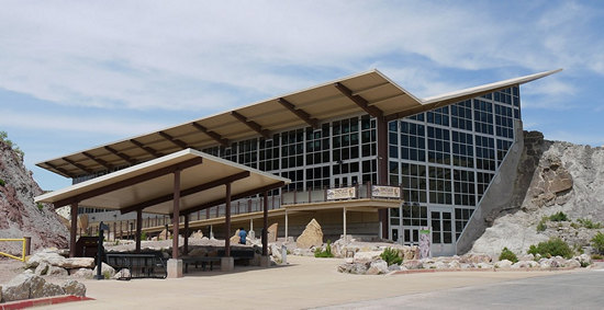
This is a shot of the bone quarry building as it stands today.
This photo is courtesy of Allison Mohr.
The building itself is worth seeing. At ground level you take a long elevated ramp to a second level. When you enter you are looking directly at the Wall of Bones.
And you have an interesting perspective on the wall as you look down to ground level from the uper deck. Both the upper and lower levels are chock full of displays which would take many hours to view, read and absorb.

I have to say when Betsy and I walked into that building and I got my first look at the Wall of Bones I got a thrill and a chill.
This statement: "Visitors can see over 1,500 dinosaur fossils exposed on the cliff face inside the Quarry Exhibit Hall." will give you an idea of the overwhelming impact viewing the Wall of Bones can have. Amazing. Can you imagine being the discoverer of such a treasure trove?
"I saw eight of the tail bones of a Brontosaurus in exact position. It was a beautiful sight…"
~ Earl Douglass.
Earl Douglass was the paleontologist who discovered the Carnegie Quarry and supervised excavations for fifteen years.

These pics make it look like a jumbled mess. How did it all get this way?
Geologist Tom Kammer explained it to me like this.
* Dinosaurs died on flood plains. Their bones were then deposited in an ancient river bed by later floods.
* Then buried in river sand. Thousands of feet of younger sediments were deposited on top, compressing the sediments below.
* The river sand was then lithified into sandstone, and the bones were petrified by minerals in groundwater.
* The sandstone layers were uplifted by mountain building processes.
* The rocks with the bones were partially exposed by erosion and then later excavated by paleontologists.
Think about that for a while...

If there is any place in the world that comes close to being the real Jurassic Park, it’s the wall of bones known as Carnegie Quarry at Dinosaur National Monument. At this spectacular desert quarry in the state of Utah, United States, visitors can see dinosaur bones as they were deposited in an ancient river bed during the Jurassic era.
Source: CarnegieQuarry.com
And, what exactly are dinosaurs?
Dinosaurs are a diverse group of reptiles of the clade Dinosauria that first appeared during the Triassic period. Although the exact origin and timing of the evolution of dinosaurs is the subject of active research, the current scientific consensus places their origin between 231 and 243 million years ago. They became the dominant terrestrial vertebrates after the Triassic–Jurassic extinction event 201 million years ago. Their dominance continued through the Jurassic and Cretaceous periods and ended when the Cretaceous–Paleogene extinction event led to the extinction of most dinosaur groups 66 million years ago.
Source: WikiPedia

Click on the pic and take a look at what appears to be a section of backbone or tail vertebrae.
The fella on the left is standing in front of a "touch me" bone.

The in situ exhibit became a reality because of the hard work of dedicated museum technicians. Frank McKnight, Jim Adams, and Floyd “Tobe” Wilkins spent years diligently removing the matrix away from the bone. Adams and Wilkins, despite having no formal education in paleontology, were dedicated students to the art of fossil preparation. The wall of bones as an idea for an exhibit had emerged since the quarry’s inception, but the hard work of museum technicians made it possible.
Source: CarnegieQuarry.com

There were cables strung about the wall with what looked like sensors attached to them. I meant to ask about them but I forgot.
Don't forget to click on this and the other Wall pics for a better look.

My last wall shot. The density and number of bones here is staggering.

This is the right thigh bone of an adult Camarasaurus. The largest species reached up to 75 feet in length.
Camarasaurus was a genus of quadrupedal, herbivorous dinosaurs. It was the most common of the giant sauropods to be found in North America. Its fossil remains have been found in the Morrison Formation of Colorado and Utah, dating to the Late Jurassic epoch (Kimmeridgian to Tithonian stages), between 155 and 145 million years ago
Source: WikiPedia

This is a life reconstruction of a Camarasaurus supremus herd by Dmitry Bogdanov.

This Camarasaurus was just a youngster.

I loved this mural and took several shots.

This youngin' was doing an imitation of the Allosaurus.
Allosaurus was a large bipedal predator. Its skull was large and equipped with dozens of sharp, serrated teeth. It averaged 8.5 m (28 ft) in length, though fragmentary remains suggest it could have reached over 12 m (39 ft). Relative to the large and powerful hind limbs, its three-fingered fore limbs were small, and the body was balanced by a long and heavily muscled tail.
Source: WikiPedia

Excitement!

What a great way to make them bones come alive!
We wandered around a bit more on the lower level, went back to the upper level for another look around then exited and walked back to the Visitors Center which took about 10 minutes.
Now it was time for hike.

This is a snippet from the Monument map. It shows the Quarry area and also the hike we would be taking - the 3. 2 mile "Sound of Silence Trail" which is the magenta line.

As we drove down CR 149 towards the Green River we got a few peaks of beautiful Split Mountain.

That is Split Mountain in the background.

Here we are at the beginning of the Sound of Silence Trail. When we first arrived I was wondering if we were indeed going to have a hike in Silence as there was a Ma, Pa and two kids starting just before us and the Pa was screaming and gesticulating wildly at the daughter as then went down the trail. This continued until they went around the first bend in the trail and out of sight.
Fortunately by the time Betsy and I got on the trail and then spent some time taking snaps they were well ahead of us and we never hear or saw them again. Yippee!

The trail led us in the direction of those interesting and beautiful formations.

What a gorgeous day! Although by now it was getting a bit warmish.


The first section of the trail took us through a wide and open wash. But that would soon change.

This image conjured up a memory of seeing something similar in Avant-Garde magazine. That would have been back in the 60s'.

Now we are being absorbed into the landscape and made to feel insignificant in comparison.

The trail then left the wash and took us into a narrow and tight gully the sides of which were quite intriguing.

Lots of geologic puzzlers here. At least for us.

This photo does not show it but this sliver had a slight blueish cast to it.

Beautiful. And to us - mysterious as it relates to it's formation.


A look back whence we came.

The trail left the gully and took us up a short, steep climb to a wide area above it.

Here Betsy reads from the guidebook we picked up at the trail head. That ragged top in the background is Split Mountain.

Bighorn sheep scat? It looks like it might be.

Some Utah juniper (Juniperus osteosperma) trees were loaded with "berries" while others had nary a one.

Gorgeous scenery. And not one person to be seen or heard. Heaven.

I am not sure what type of conglomerate rock this is but it is fantastic clastic !

Lots and lots of itty-bitty clasts.
Clastic rocks are composed of fragments, or clasts, of pre-existing minerals and rock. A clast is a fragment of geological detritus, chunks and smaller grains of rock broken off other rocks by physical weathering. Geologists use the term clastic with reference to sedimentary rocks as well as to particles in sediment transport whether in suspension or as bed load, and in sediment deposits.
Source: WikiPedia

It is hard to discern here but there were lots of ants scurrying about between the pebbles and in the process moving them about.

Some of these ancient Junipers end up with some pretty strange shapes.

How would you like to have something like this as a yard tree? Yes, please.


Here is a good example of how some of the rocks got the way they are - in very recent times that is. This dome shaped piece has cleanly separated from the parent rock. How? Maybe frost/freeze action?

From up on the other side of the ridge this wall like row of stones conjured up the image of a buried dinosaur with it's backbone sticking above there surface.

Betsy had noted some cautions about rock scrambling in the guide. I don't know if this counts or not.

Be careful Betsy!!

Could this be the famous "slickrock" that all the Mt Bikers rave about?
The so-called "slickrock" sandstone, which forms the majority of the trail's surface, is not slick at all, but has a surface much like sandpaper. The rubber tires of a mountain bike or off-road motorcycle will grip readily to its surface on all but the steepest hills. The sandpaper texture is notorious for inflicting severe abrasion injuries.
The name "slickrock" was given by early settlers of the area because their horses' metal shoes had difficulty gaining traction on the rock's sloping surfaces. The same is true today for cyclists who use shoes with metal cleats while riding the Slickrock Trail. Slickrock also becomes very slick when wet.Source: WikiPedia

Here is a brain twister. How did that cylindrical piece of rock end up where it is? Sheesh!

This may be Banana yucca (Yucca baccata) although I can't be sure.
When we got back off the trail we continued on down the road in the direction of Split Mountain, the Green River and the cabin of Josie Morris.

There is nothing quite like the scenery of the wide open west.

Another great view of Split Mountain.

Here you can clearly see the split in Split Mountain.

Here are more details about the Split. Click to read.

The great scenery just kept on comin'.

The paved road turned to dirt and became Cub Creek Road. This road dead ends into the old cabin and homestead of Josie Morris. Josie was quite the unusual lady.

Josie married five times and she divorced four husbands, in a time when divorce was almost unheard of.
With no money to buy property, Josie decided in 1913 to homestead in Cub Creek. Here she built her own cabin and lived for over 50 years. She shared her home with her son Crawford and his wife for a time; grandchildren spent summers working and playing alongside Josie.
During Prohibition in the 1920s and into the 1930s, Josie brewed apricot brandy and chokecherry wine.
After a lifetime of dressing in skirts, she switched to wearing pants in her later years. She was tried and acquitted twice for cattle rustling when she was in her 60s.
At the age of 71, in an ambitious move to revive a profitable cattle business, she deeded her land away and lost all but the five acres where her cabin still stands. In December of 1963 the legendary Josie suffered a broken hip while in her cabin; she died of complications in May of 1964.Source: NPS

Josie was able to use water from Cub Creek for irrigation but she also had this spring water which she probably used for drinking.

The water was so cool and clear it was tempting to take a long, deep drink. But the warning about Giardia scared me off.
We then left the cabin area and decided to mosey on down to the river.

We were treated to still more nice views of the mountains as we drove over to the Green River.

There is lots of activity here on the Green River in the summer as this busy staging area for rafts and other watercraft will attest.

There are several companies that run multi day trips on the Green River and some of those folks were just returning.
By now it was Happy Hour so we headed back into town and had our beers and munchies on the "balcony." For supper we decided on pizza.
There is Dominoes right across the street from the Sage motel so we decided to get it from them. But, then I had the big idea of going local so we ordered from 4 Brothers Pizza instead. Mistake! We told them we needed plates and asked for crushed red pepper flakes also. Neither were delivered.
I called them up and after what seemed like 10 minutes of hassling with them they said they would send the delivery boy by with the plates and pepper.
By the time they arrived my pizza was cold and I had to nuke it. Betsy was smart. She used the lid of the pizza box for a plate and got hers while it was still hot. Me big dummy...
Tomorrow we head north for more spectacular scenery and geologic wonderment.
Thursday, August 9th
A Windshield View of the Sheep Creek Geological Loop
and a Look Around Flaming Gorge
While doing some research on things to do and places to go I came across a scenic drive called the "Sheep Creek Geological Loop". After reading a bit about the area and seeing some online photos I decided we needed to put it on the list along with Flaming Gorge.
So on Thursday moring we departed Vernal UT and headed north on US 191 to check out the Sheep Creek area.
We had barely driven 15 miles when we saw a sign we had seen on various other trips "WARNING: Blasting Ahead". Never before had that amounted to anything in the way of delays. Today would be different. And soon we were at a dead stop.

After sitting in our vehicle with numerous other folks for nearly half an hour there was a thunderous explosion and above is what we saw.
The reason for this blasting? The Simplot phosphate mine.
Phosphate ore is mined 12 miles north of Vernal, Utah, where it is also crushed, washed, finely ground and concentrated. The ore is then mixed with water to form a slurry and shipped 96 miles through a pressurized pipeline to the manufacturing plant five miles south of Rock Springs, Wyoming. Molten sulfur (which is burned in fertilizer production to provide heat, steam, and sulfur dioxide gas) is supplied by various vendors, as is ammonia, the third raw material used in production.
Source: Simplot
About Simplot:
The J.R. Simplot Company, a privately held agribusiness firm headquartered in Boise, Idaho, has an integrated portfolio that includes phosphate mining, fertilizer manufacturing, farming, ranching and cattle production, food processing, food brands, and other enterprises related to agriculture.
Simplot’s major operations are located in the U.S., Canada, Mexico, Australia, and China, with products marketed in more than 40 countries worldwide. The company’s mission statement is Bringing Earth’s Resources to Life.Source: Simplot
It would be interesting to know why Simplot did not build a processing facility in Vernal and instead move it 96 miles via pipeline to Rock Springs.
We finally got moving and then enjoyed the very scenic trip to the Sheep Creek Geological Loop which was about 60 miles from Vernal.
Here is the obligatory orientation map.

The Sheep Creek Geological Area is in the Uinta Mountains and here is the skinny on them.
The Uinta Mountains are an east-west trending chain of mountains in northeastern Utah extending slightly into southern Wyoming in the United States. As a subrange of the Rocky Mountains, they are unusual for being the highest range in the contiguous United States running east to west, and lie approximately 100 miles (160 km) east of Salt Lake City. The range has peaks ranging from 11,000–13,528 feet (3,353–4,123 m), with the highest point being Kings Peak, also the highest point in Utah. The Mirror Lake Highway crosses the western half of the Uintas on its way to Wyoming.
Source: WikiPedia
Here is a snippet of the information posted on the USFS web page for the "Sheep Creek Geological Area".
This area is located adjacent to the Flaming Gorge National Recreation Area and connects to the Uinta National Scenic Byway described above. You can begin in Manila City, Utah at the U.S. Forest Service Office & Manila Orientation Center on State Road 44.
Named after the Rocky Mountain Bighorn Sheep that inhabit the area, this site is dominated by the Uinta Crest Fault, a section of folded and twisted rock that reveals millions of years of geological history. Along Highway 44, signposts explain the denote formation names and geologic ages as you pass through them.The youngest formation exposed in this region is the Mancos Formation. Formed from clay that settled out of a large Cretaceous sea, this formation is home to many sea creature fossils. ...
The Pennsylvanian period gives us the Weber and Morgan Formations. The Weber Formation is easily eroded by water due to poor cementation of sand grains resulting in deep gorges in the area. ...
Finally, the Precambrian Uinta Mountain Group is more than three miles thick. Few signs of primitive life are found since it was deposited a billion years ago.
If you would like to "fill in the dots" check out the full text by clicking on the link above.
If you want to dig deeper you might find this Geologic Road Guide to Sheep Creek Canyon Geological Area of interest.

Just barely seen on the right is the steep and winding road we would be taking down into the canyon.

This was to be how the day would go - one stunning view after another.

It is nigh on impossible for me to comment on what we were seeing. And, truthfully, we did not ponder it much but merely took in the scenery and engaged in much "oohing and ahhing".
Besides rock gawking Betsy was also scanning for Big Horn sheep which are known to be in these here parts. Betsy kept scanning the rock faces through out the canyon but she was never able to spot any of the illusive critters.


Thankfully we saw very few people out on the loop.

Here is a look at the Uinta Fault, the contact between Madison Limestone and Uinta Mountain Group sandstones and mudstones.
Can you guess what Betsy is saying? I think it was something like: "Wow..."
The Uinta Mountains are Laramide uplifted metasedimentary rocks deposited in an intracratonic basin in southwest Laurentia during the time of the breakup of the supercontinent Rodinia. The marine and fluvial metasedimentary rocks in the core of the Uinta Mountains are of Neoproterozoic age (between about 700 million and 800 million years old) and consist primarily of quartzite, slate, and shale. These rocks comprise the Uinta Mountain Group, and reach thicknesses of 4 to 7.3 kilometres (13,000 to 24,000 ft). Most of the high peaks are outcrops of the Uinta Mountain Group. Many of the peaks are ringed with bands of cliffs, rising to form broad or flat tops. The mountains are bounded to the north and south by reverse faults that meet below the range, on the north by the North Flank fault and on the south by the Uinta Basin boundary fault.
Source: WikiPedia


Soon after this shot we wound our way down to creek level and then were looking up at all the cool rocks.
We stopped briefly at the Palisades Picnic area for a snack and to enjoyed the grove of trees which nicely shaded the picnic tables. The picnic area is at about 7000' elevation.

The grove of trees which shaded the picnic area were mostly the same species. Here is a look at the bark of one of the shade trees.
Look familiar? It sure did to me. But the leaves did not.

Here are the leaves which go with the bark pictured above. To me, the bark looked it belonged to a Cottonwood tree but the leaves did not match. Or so I thought.
That is because I was ignorant of the fact there is a Narrow leaved cottonwood. Guess what it has? Narrow leaves! Up until this point I was familiar only with the leaves of the Eastern cottonwood which have a very different shape.

The above is a leaf from the Eastern cottonwood (Populus deltoides) which I am most familiar with. Below is a range map for the Eastern cottonwood next to the range map for the Narrowleaf cottonwood.
Range maps for Narrowleaf and Eastern Cottonwood

As you can see the Narrowleaf cottonwood (Populus angustifolia) is much less widespread than the Eastern Cottonwood.
Not only is this the first time I remember seeing Narrowleaf cotton wood, it is the first time I have ever identified a tree species using my smart phone which was just acquired this past May.
In July I downloaded the app "Vtree" which is a Virginia Tech Tree ID app for phones and tablets. I like it. It is easy to use and well layed out. If you want to give it a try you can download it from Google Playstore. It is free of charge and runs no adverts. Groovy.

At one time there was also a campground here. It was closed. This plaque tells us why.

Just down the road from the picnic area we spotted the discharge spring for Sheep Creek Cave. It is call Big Spring.

The discharge is about 50' below the cave entrance.

You can't miss this one. It is easily seen from the roadway.

I crossed the creek for a closer look and also found the path up to the cave. A permit is required to enter the cave. However, that does not stop some people. We could see a group at the entrance. The gate was open. The folks down on the road who were with them told us; Oh, you don't need a permit, everyone goes in. Apparently the USFS is not checking to see if the gate is locked or not and so there is easy access for all. Hopefully this will come to a stop at some point.

We are now winding up our tour of the Sheep Creek area but there are still plenty of pretty rocks to gawk at.


Shown here is one of the many roadside markers indicating what geologic formation you are looking at. I was puzzled by the letters on the left side of each sign. They seemed familiar but I could not put my finger on why. So I emailed GeoKam who of course had the answer: They are map symbols. Ah ha! I knew I had seen them somewhere. And that somewhere was on a geologic map for the state of West Virginia. Mystery solved.

This was the last prominent roadside promontory we would see - Tower Rock.

Tower Rock, in the northeastern section of SCCGA, is a hoodoo rock formation that resembles a tower constructed against the steep cliffs that rise alongside the loop road. A hoodoo is a rock pillar that has been carved into a fantastic or eccentric shape by different rates of weathering and erosion of different parts of the pillar due to variations in the rock’s resistance. Tower Rock is composed of Weber Sandstone, and the large-scale cross-bedding and well-sorted quartz sand grains indicate that this sandstone was originally wind-blown sand dunes. These ancient dunes accumulated around 285 million years ago during Early Permian time.

Now that we have left the Sheep Creek Canyon, the landscape has shifted from rock gawking to agriculture.


How would you like to wake every morning and see this? The white flowers on the lower left are from a vine known commonly as Western Virgin's Bower. This species may be (Clematis ligusticifolia) which has a wide range in the west.
Clematis ligusticifolia is a climbing, spreading vine with showy flowers. It is also known as Old-man's Beard and Yerba de Chiva, and Virgin's bower, (though Old-man's Beard may also refer to C. vitalba, and Virgin's bower may also refer to C. lasiantha). It is native to North America where it is widespread across the western United States in streamside thickets, wooded hillsides, and coniferous forests up to 4,000 feet.
It was called "pepper vine" by early travelers and pioneers of the American Old West. They used it as a pepper substitute to spice up food since real black pepper (Piper nigrum) was a costly and rarely obtainable spice. Like the rest of the Clematis genus, it contains essential oils and compounds which are extremely irritating to the skin and mucous membranes. Unlike Black Pepper or Capsicum, however, the compounds in clematis cause internal bleeding of the digestive tract if ingested internally in large amounts. The plants are essentially toxic. Despite its toxicity, Native Americans used very small amounts of clematis for migraine headaches and nervous disorders. It was also used as an effective treatment of skin infections. A whole-plant hot water extraction was used to treat eczema, and a leaf compress is used to treat chest pain, sores, and boils.
Source: WikiPedia

Purty.

Our last sign and then we were once again out on the open road.

This was shot at the road intersection of SR 44 and US 191. From here we would head north on 191 for about 6 miles to the Flaming Gorge Visitors Center.

One more shot of Betsy on the Rocks and we were on our way.

The route to the visitors center took us up and up and we soon had commanding views of the "Flaming Gorge" reservoir.
Flaming Gorge Reservoir is the largest reservoir in Wyoming, on the Green River, impounded behind the Flaming Gorge Dam. Construction on the dam began in 1958 and was completed in 1964. The reservoir stores 3,788,900 acre feet (4.6735×10 m) of water when measured at an elevation of 6,040 feet (1,840 m) above sea-level (maximum).
The foundation of the reservoir is a steep-sided narrow canyon composed of siliceous sandstone and hard quartzites inter-bedded with softer shales, siltstones, and argillites. About 1.5 miles (2.4 km) east of the dam, a road cut has revealed a fault scarp on the southbound side with about 9 feet (3 m) of slippage.
Source: WikiPedia
To have a reservoir you gotta have a dam. Right?
Contrary to its namesake, Flaming Gorge, the dam actually lies in steep, rapid-strewn Red Canyon in northeastern Utah, close to where the Green River cuts through the Uinta Mountains. The canyon for which the dam is named for is buried under the reservoir, almost 20 miles (32 km) upstream. Red Canyon is the narrowest and deepest of the four on the Green in the area (Horseshoe, Kingfisher, Red and Flaming Gorge) which made it the best site for the building of a dam.
Flaming Gorge, on the other hand, was named by John Wesley Powell on his 1869 expedition down the Green and Colorado rivers for the "brilliant, flaming red of its rocks [when the sun shone upon them]."Source: WikiPedia

As we climbed even higher we were presented with this beautiful view back towards the Sheep Creek Canyon.

Now that is what a I call a "hair pin turn"!

This was taken from the observation area on 191. As in the Sheep Creek Canyon we saw surprisingly few people while looking around the Flaming Gorge area.

We made a brief stop at the Visitors Center. As might be expected there is a large glass enclosed area of the building which faces the gorge. This was shot through that glass. Note the sign in the lower right.


That Betsy! She is such a flirt.

The rest of the time we spent in the Gorge area was on and off clouds and I grabbed a few more shots when I could.

This sign was near the visitors center along the Rim Trail. We walked about 2 miles out and back. The trail was not too inviting. There had been both fire and beetle damage to the trees and it was pretty beat up looking.

Pretty dramatic to say the least.

This is a shot of an observation deck which was along the Rim Trail. Very nice placement with a short flight of steps going down to it.

Now we know why we did not see any Big Horns in Sheep Creek Canyon - they were all here at the Gorge!

I kept snapping as I kept driving, hoping they would not scatter.

Scatter? HA! I had to nudge some of them off the road to get through.

They paid us no mind as I pulled up right along side of them.

If you look closely you can see one of the sheep has an orange tag and the antenna from a tracking collar.
What a great way to end our day on the road. Soon we were heading back to Vernal for our Happy Hour and then SW salads from Micky D's for supper.

Tomorrow we will be pulling up stakes and heading south as we continue with our loop tour of Wyoming, Utah and Colorado.
Seeya then...
Mike and Betsy
![]()
![]()