Wednesday: January 19th
Around 10 am we said goodbye to Bruce, Mia and Green Valley and continued our journey west. The next stop would be Organ Pipe Cactus National Monument.
Our route west would take us back up I-19 to South Tucson where it intersected with Rt 86. Almost as soon as we got off the exit we saw a Food City - home to La Guacamaya hot sauce. Since we had purchased the
last remaining bottle the day before, we decided to look for more.
We entered the store and went to the hot sauce section. There on the bottom shelf were dozens of bottles of La Guacamaya so we grabbed 2 and headed to the register where we also picked up some curious tasting and looking Mexican snacks which had a hot, limey flavor and were shaped like tiny tacos.
We continued west on Rt. 86 finally getting out into open desert and leaving all the crap of humanity behind.
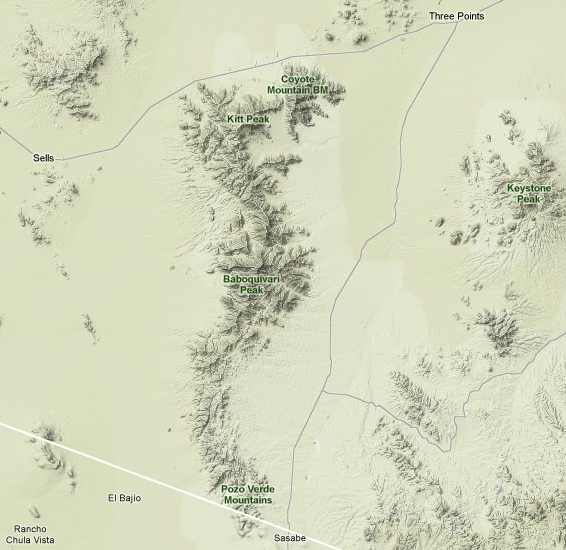
Soon we saw Keystone Peak, the Coyote Mts and Kitt Peak, the latter being home to the famous
Kitt Peak National Observatory. At 7730'Baboquivari Peak dominated the landscape.
Base Map: © Google Maps
At about 50 miles west of Tucson we passed through the small town of Sells. We were now in the Tohono O'odham reservation we passed through in 1996.
The Tohono O'odham are a group of aboriginal Americans who reside primarily in the Sonoran Desert of the southeastern Arizona and northwest Mexico. "Tohono O'odham" means "People of the Desert." Although they were previously known as the Papago, they have largely rejected this name (meaning literally "tepary-bean eater"), which was applied to them by conquistadores, who had heard them called this by other Piman bands unfriendly to the Tohono O'odham. The term Papago derives from Papawi O'odham, that with time became Papago. Pawi is the word for tepary bean in the O'odham language, Papawi the plural.
Source: WikiPedia
We remembered Sells as being depressing and trashy looking. On that trip, in 1996, we saw garbage strewn about everywhere and the whole place had an air of desperation about it.
It was different this time. Thanks to all the gaming money generated, this set off a series of events which are documented at the
Tohono O'odham history page.
1993: The Tohono O'odham Nation signs its first Indian gaming compact with the state of Arizona, and Papago Bingo becomes the Desert Diamond Casino.
2000: Tohono O'odham Community College, which was chartered in 1998, begins offering classes.
2002: Archie Hendricks Sr. Skilled Nursing Facility opens.
2002: A new Desert Diamond Casino opens at 1-19 and Pima Mine Road.
2003: Land for the Hia-Ced O'odham is purchased near Why, Arizona.
2004: Radio station KOHN-FM 91.9 starts broadcasting.
2005: Recreation Centers open at five locations throughout the Tohono O'odham Nation.
2007: Tohono O'odham Cultural Center and Museum opens.
2007: The old Desert Diamond Casino is replaced by a new facility including a hotel. The Tohono O'odham Gaming Enterprise operates three casinos.
2007: Sells DaVita Dialysis Center dedicated.
2007: San Simon Health Center dedicated.
Now we saw a transformation at Sells which had much less garbage, sidewalks, along with new schools and health facilities.
At Sells, Rt 86 jogs north through more open desert. We saw many fine Saguaro and Cholla, but no Organ Pipe Cactus - yet.
We arrived in Ajo early afternoon. On the eastern outskirts of the town, the huge spoil banks left over from decades of open pit copper mining were visible long before we arrived in Ajo proper.
High-grade native copper made Ajo the first copper mine in Arizona. Soon the Arizona Mining & Trading company, formed by Peter M. Brady, a friend of Childs, worked the rich surface ores, shipping loads around Cape Horn for smelting in Swansea, Wales, in the mid 1880s. The mine closed when a ship sank off the coast of Patagonia. Long supply lines and the lack of water discouraged large mining companies
With the advent of new recovery methods for low-grade ore, Ajo boomed. In 1911, Col. John Campbell Greenway, a Rough Rider and star Yale athlete, bought the New Cornelia mine from John Boddie. He became general manager of the Calumet and the Arizona mining company and expanded it on a grand scale. The Tucson, Cornelia & Gila Bend Railroad was built from Gila Bend to serve the mining industry and was in service from 1916 to 1985.
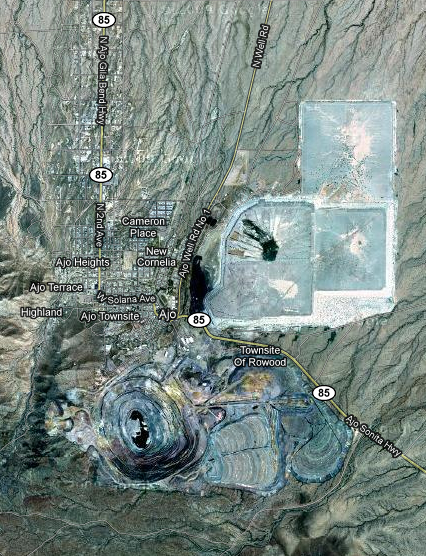
In 1921, Phelps Dodge, the nation's largest copper company, bought New Cornelia and the mine became the New Cornelia Branch of Phelps Dodge, managed by Michael Curley. For several decades more than 1,000 men worked for Phelps Dodge in the open pit mine. The mine closed in 1985, following a bitter strike and a depressed copper market. Ajo is now home to many retired people, to Border Patrol agents, and young families.
Source: WikiPedia
The size and dominance the old workings had on the landscape were quite amazing and we quickly saw had it not been for the mine, the town of Ajo would not exist.
Had things been different Ajo might have ended up a ghost town. But, like the old mining town of Bisbee it has remade itself into a retirement and tourist town which we found to be clean and thriving - for now.
As we made our way through the small downtown, we noticed several nice churches, the town plaza and the old rail road depot. All were in good condition and obviously well maintained.
While sitting at the only stop light in town at Rt 85 and La Mina Avenue, I looked down La Mina Ave and caught a glimpse of a sign with "Hotel" on it. On the eastern outskirts we had seen a sign for the "Marine Motel" as well. We also knew (according to web research done previously) we should, at some point, come across the "La Siesta Motel & RV Resort".
We passed by street after street of mostly well kept old company houses, then up to "Ajo Heights" and to the western outskirts of town. Here we saw a mish-mash of businesses, tourist shops (some of which looked like junk yards) cafes, bakeries, restaurants, gas stations, etc.
We also noticed the offices and visitors center for the
Cabeza Prieta National Wildlife Refuge which, at 640,000 acres, is the third largest wildlife refuge in the lower 48 states (Desert National Wildlife Range being the largest).
Not far past the Refuge HQ we spotted the "Marine Motel" on the right. It looked a bit funky, but not too bad. We continued on west but saw no sign of the "La Siesta Motel & RV Resort". Finally, we headed back towards town and at some point Betsy got out and asked about the location of the La Siesta. It turns out we had not gone far enough so we back tracked and saw the palm trees on the left which were the landmark given to us.
Betsy went to the office to check on rates and we looked at a room which was actually a tiny cabin which had a nice view of the RV "resort". Not too appealing, especially at 70 bucks a night!
So, we headed back east to the Marine to check it out.
Long story short - it had a 0 star rating and the room rates were 50 bucks a night. This is what happens when you are in the middle of nowhere near a popular tourist destination like Organ Pipe Cactus National Monument - you can charge rates waaaay over what you could get anywhere else.
So, we got a room for 2 nights. The place had some curious amenities like: no plug for the sink, the microwave and microfridge were set up so you had to stretch the cords across the sink and plug them in to operate them then unplug them to use the sink. The mattress shuddered at the slightest touch and was about 2" thick.
Directly outside the front door of our room was a nice assortment of cigarette butts, pull tabs, broken glass and other assorted bits of trash. I thought this was a nice touch.
The only positive thing about this place was a view of the distant mountains framed by a section of mine spoil bank on one side and yet another RV park on the other. Nice.
We unloaded the car and then headed back towards town hoping to find a bite to eat. We did - at
Marcella's Cafe and Bakery where we split a jumbo cheese crisp and washed it down with a Corona and a Coke.
Then it was down to the visitors' center for the Cabeza Prieta National Wildlife Refuge where a very helpful, knowledgeable and enthusiastic fellow by the name of "Mike" gave us all kinds of ideas for our current and future visits.
We then drove back downtown to have a look-see at the source of the hotel sign I had seen earlier. It turned out to be the old Hotel Cornelia. Betsy tried the door but got no answer and the place appeared to be undergoing some sort of renovation. Hopefully it will be open the next time we are out that way.
Betsy's knee was bothering her, so we canned the idea of an Ajo walk about and instead went back to our squalid little room at the Marine Motel and tried to relax while some housekeepers and their kids ran back and forth and engaged in constant bilingual chatter.
Later we had our usual hotel meal of salad with grated parmesian cheese washed down with beer. We sat out on the stoop for a while and watched the distant mountains turn pinkish from the setting sun.
While Betsy continued to read "Ender's Game" I amused myself by reading Betsy's journal entry from 1996 (see below). That was our first visit to Organ Pipe and we had not returned since. At that time Betsy was a child of 45 years old and I was barely out of my 30s. How time flies...
Tuesday: December 25th, 1996
...we moved slowly getting things together and didn't leave till a little after noon. We arrived at Organ Pipe around 3:00 just as the rangers were leaving - the visitor's center was already closed. We chose a nice site and set up Paula's tent (which turned out be a VE-24) under a Palo Verde tree.We sat at the picnic table and had beer, wine and sausage and bread. A gila woodpecker came up to beg for scraps!
I forgot to mention that we stopped in Why for wine. I had a choice between Riunite and Italian Swiss Colony. I chose Riunite Cabernet-slightly sweet and watery, with a classic Riunite taste!
We took a 2.5 mile desert hike and came back to the campsite to cook our curried lentil soup.
The wind was rapidly rising and a bank of clouds appeared. Mike gazed worriedly at the sky, wondering where the moon was. We sat in the gathering darkness, enjoying the desert breeze and making deprecatory remarks about our "neighbors" glaring lantern which we could see through the trees. Mike got up, walked to the edge of our camp site and called me over. I walked over to him and saw that our neighbor's glaring lantern was a beautiful full moon!I went to the 7:00 program on the Mountain Lion, "The Silent Hunter of the Sonora." Mike opted out because it was multimedia. It was pretty interesting, but I stayed to the end mostly because I thought we were going to sing Christmas carols, but it turned out the ranger was kidding!
The wind was really blowing by the time I went to bed. It beat and whipped against the tent. After what seemed like hours, we got up to "take a leak" and I thought it was 6:00 a.m.-time to get up. It turned out to be 11:30 p.m.-still Dec. 24th.
Wednesday: December 25th, 1996
We got up Christmas morning about 7:00 a.m. to a cool windy desert scene. Unfortunately, the stove didn't work and neither did our attempts to find coffee. So, coffeeless, we breakfasted on cookies and banana bread under a ramada at the visitors' center. We opened our gifts from Paula and Ginny, then headed out to drive the 50+ miles of the Puerto Blanco desert loop.The scenery was absolutely gorgeous and the temperature went up as we drove. At one point we got out to take a hike up a trail and we flushed a javelina-a wild pig. We'd both been hoping to see one. We saw several and fairly close, too! Some birds we saw on our drive were:
Phainopepla, cactus wren, curved bill thrasher, gila wood pecker, northern flicker, black throated sparrow, gambel's quail, kestrel, red tailed hawk, western mockingbird, great horned owl and road runner!At one point we walked right along the Mexican border, separated from Mexico by only a wire fence.
By the time we got back, it was 70's and gorgeously sunny (around 2:00 p.m.). We sat in the sun and had tortilla chips, bean dip and beer-it was great!
We siesta-ed in the tent and then had our second dinner of curried lentil soup cooked over an open fire.
After dinner, we walked along the road to the visitor's center and then back through the desert. We thought our way would be lighted by the full moon, but it got darker and darker and darker! We stumbled through dry washes, stopping now and then and watch the sky as more and more stars popped out-but no moon. We covered the last few feet of desert to the blacktop of the camp ground, turned around, and there was the moon peeking over a mountain. We stood and watched as it quickly came up and the whole moon could be seen.
We went to bed early for another "long winters nap."
Thursday: December 26th, 1996
We literally climbed out of the tent, hopped into the car and drove to the Lukeville Café for breakfast. Coffee tasted great after our coffeeless Christmas Day. I had an egg over easy with toast, but Mike had a bean "burro."We packed up camp, stopped at the Visitors Center, then headed out towards Nogales for our scenic drive. The cactus studded desert gave way to a landscape that reminded me of an African veldt-long tan grass with mesquite trees. The mountains were stupendous and we "ooed and ahhhed" our way around each bend in the road. We got out and walked several times. The Buenos Aires National Wildlife Refuge was beautiful, with large trees and I realized that part of the beauty was that it was a more familiar landscape to me than the cacti desert I had been seeing for the past several days.
Thursday: January 20th
We awoke to blue skies and bright sunshine. After our 1st round of morning coffee we got our hiking gear together and headed up to Marcella's Cafe and Bakery for breakfast. Betsy had a sausage and egg burro and I had the beef muchacho burro.
Click on the photos below for a larger image.

Betsy digs in as I snap a shot of our tasty breakfast.
After we polished off the burros and most of the salsa we looked over the Organ Pipe map. I pointed out the hike on the map I thought would be a good one - the "Estes Canyon / Bull Pasture Trail". Here is the trail description:
4.1 miles: Strenuous - A favorite among hikers here. This combination of two trails leads you up to an amazing vista, jumbled geology and wonderful flowers. The pasture was used by supporters of Pancho Villa as a hide-out!
Although Betsy's knee was still bothering here, she was game for the hike I had chosen.
We headed back out of town to the poke-and-plum town of Why and stayed south on Rt 85.

Base Map: © Google Maps

This is the view just shortly after we crossed over into Organ Pipe. Incredible.

It was hard not to keep snappin' and I burned up some "film" trying to capture this vista.

The view to the west of where we pulled off to enjoy the scenery.

There were many fine Cholla, Saguaro and Mesquite.
Soon we came to the Visitors' Center on the right and then saw the Ajo Mountain Drive on the left. The Drive is a 25 mile loop that winds through the desert and up and over passes in the Ajo Range. The Park Map showed our trailhead being about halfway around the loop.

This is one of many fine views of the Ajo Range seen from the Drive.

A favorite pastime since people first came to this area is enjoying the sometimes whimsical, sometimes bizarre shapes the Saguaro grow into.
I thought this tall one looked like its arm was around another one.
Note the
Kestrel on the very top.

Finally - Organ Pipe Cactus!
This was the first of many fine specimens we were to see. Betsy is flanked by two nice Ocotillo, and, as yet, unbranched Saguaro.

Although appearing crispy dry, the Sonoran Desert Region is often said to be "the wet desert" because of the diversity and density of the vegetation.

This is the first of two picnic areas on the Ajo Mountain Drive. This one is set up on a high bluff and had an incredbile view of the valley below and the distant mountains.
The ramada roof is composed of cut sections of Ocotillo.


Betsy fantasized about sitting there with a nice bottle of champagne and taking in the view and just whiling away the day. Next time...?

Another view from the picnic area.

I had to resist the urge to take a picture of every Organ Pipe cactus we saw.

But, I still ended up with quite a few!

A shot of one of the peaks as we wound our way through the Ajo Range.

If anyone had any confusion about the differnce between Saguaro and Organ Pipe cactus, this should dispell it.

Three beauties!!
Left to right:
Cylindropuntia bigelovii - the "Teddy Bear Cholla"
Stenocereus thurberi the "Organ Pipe Cactus"
Winkus breidingii the "Maid of the Desert".

We have seen thousands of Teddy Bears on this trip but most of them were in the 2-4' range in height. We were both stunned by the size of the ones we saw in the Monument.

Finally we hit the trail and saw one fab view after another and many interesting plants as well.

Betsy runs a guauntlet of Teddy Bears as we start the climb up the mountain.

I think this is Arizona Rainbow Hedgehog (Echinocereus Ridigissimus). They were not as common as other cacti, but we saw them scattered amongst the rocks and ledges along the trail.
The Hedgehog cacti are sometimes referred to as
"Claret Cup" cacti.

Another view of the Rainbow Hedgehog, Ocotillo and the valley floor where we started our hike.

We made it!

Although this is the official summit and end of the trail, I decided to scramble to some higher points get some different views.

This view is to the south looking into Mexico and the Sierra del Santa Rosa mountains.

Looking northeast into the Ajo Range.

In the foreground are the notorious "Shin-daggers" (Agave lechuguilla) and "Fish Hook" cactus (Mammillaria grahamii).
When I returned from my exploring around the summit, I joined Betsy on top of a nice sunny boulder and we sat there having a snack and enjoying the view and the total silence.
Then, rested and fueled up, we started back down the trail.

Here area a couple more shots of the hedgehog I took on the way back down the trail. The sun was starting to set and we were now in shadow on this side of the peak.

You wouldn't want to fall on these spines!

Growing right out of the rocks - I never cease to be amazed by this.

Here area a couple obligitory fern shots.
I am very poor at identifing
xeric pteridophyes but I will take a stab at it: Spiny Cliffbrake (Pellaea truncata)??

Star Fern (Notholaena standleyi) ???

Shin-daggers and one of the species of "Beaver-tail" cactus.

Many of the rock surfaces were covered with lichens of various shapes, colors and sizes.

The lichen covered rock shown above.

The trail intersection sign for the Bull Pasture and Estes Canyon Trails. We had ascended via the Bull Pasture trail and would now return via the Estes Canyon Trail.

Palo verde tree is common in the Sonoran Desert but was sparse in this area of the Monument.

When we reached the canyon floor we saw many more fine Cylindropuntia bigelovii - the "Teddy Bear Cholla"

These Teddy Bears must have easily been 8' tall. WOW!

A baby Organ Pipe cactus. Like the Saguaro, the Organ Pipe has a very limited range.
This species is found mostly in Mexico, mainly in Sonora and southern Baja California. It is also known to the United States, but is much rarer, with the notable exception of Organ Pipe Cactus National Monument. The plant is predominantly found on rocky hillsides up to 3000 feet (900 m) in elevation. It is sensitive to frost, so the species is rare in low desert areas, which can be more susceptible to frost.
The plant is slow growing, and prefers well-drained soil and full sun. However, when in the seedling stage, it requires shade, and will grow beneath a "nurse tree". It will need this for several years until it grows an adequate root system, which is mostly in the upper 10 cm of soil.
Source: WikiPedia

Although I could find no info on Organ Pipe growth rates I bet this plant and the one below are well over a 100 years old.

This was the last shot on this truely amazing hike. We are both looking forward to it again next winter.
After a brief stop at the visitors' center where we found postcards and two bored and unengaging staff members, we headed back to Aho. By now our thoughts were turning to munchies and cold beer.
Friday: January 21st
After breakfast we stopped at the new looking IGA supermarket directly across from the motel. We needed milk and few other things (fritos! beer!) and decided to shop before heading over to the Monument.

At the entrance to the store, this woman was roasting Anaheim chiles, bagging them up, and then placing them on a rack inside the store.

I asked her about the process, type of chiles, etc. She said she roasts 8-9 25lb. bags a week.

This roasting cage had a gas jet burner on the back side and was turned by an electric motor attached to gear box.

YUMMY!
Shopping done, we drove back over to the Monument. We wanted to check out the primitive camping area and also hike the short (2 mi) Alamo Canyon trail which followed a wash up to an old rancher's settlement.

Two of the 4 sites were occupied and we decided # 1 was the primo site, thinking we would get back at some time and would ask for that one.

We started the leisurly saunter up the wash.

Here, some of the mesquite and Palo Verde had leaves emerging and we saw a few Ocotillo in bloom. Obviously this was a wetter area than we had been to yesterday. Why, I do not know.

I noticed this odd protuberence on one of the Chollas.

I don't know what might have caused it. A responce to damage? A branch bud? Any ideas??

The end of the hike. This is the old rancher's place. There was a nearby well in the wash with an old electic pump and a water storage tank and watering trough. The concrete work look relatively new, so this place was not an ancient ruin or anything.
Here we met one of the people who was at the primitive sites. He was from Boston and had fled the cold weather as we had.
We then went over to the developed campground area and went for a nice hike - the "Desert View Trail". It had some interpretive signs and gave a good overview of the desert environment.
Then it was back to the hotel to do some preliminary packing for our departure the next day. From here we would head up to to Chandler via an interesting mountain road. Then, an overnight visit with long time friends Jeff and Colleen and then the start of our trip back home via...
Next installment: Big Bend National Park
'Till then... Adios!
~ Mike and Betsy