Thursday, October 12 - Part 2
Around 10:00 AM I left the Ancient Ones behind and was back in the Valley by 10:30 or so. I continued north on US 395. My destination for the day was the town of Bridgeport where I was to spend the night.

Source: © Google Maps
Click on these photos for a higher resolution.
They will be slow to load with a dial-up connection.

I detoured off 395 to Mammoth Lake. As I climbed up into the Ski Area the change in vegetation was quick and dramatic. I decided I would check out Devils Postpile National Monument. However, when I got to the entrance and saw yet another Fee Station, I turned around and left.
On the way back over to 395 I noticed a small dirt road going off into the woods. I parked and walked down it for a ways. I came to the open area of mixed scrub and conifers shown above. Just near here two RVs were parked and had set up camp. Nice spot to spend a few days.
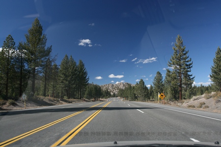
Back out on 395 the roadway had left the Valley and climbed up into the foothills.

I am sure this roadway cut, shot through the windshield, would have yielded some interesting stories about the local geology.

This was shot just at the crest of the grade which goes down to Lee Vining and Mono Lake.
Lee Vining was named after Leroy Vining, who founded the town in 1852 as a mining camp. His life came to an untimely end when he accidentally shot himself at the nearby town of Aurora, Nevada. Originally the town was named "Lakeview", but when a post office was sought, it was learned that another town, Lakeview, California already had the name. The truly unique name of Lee Vining was then chosen.
Source: WikiPedia
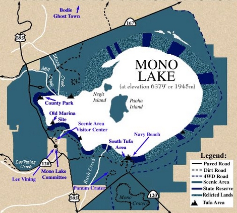
Mono Lake is believed to have formed at least 760,000 years ago, dating back to the Long Valley eruption. Sediments located below the ash layer hint that Mono Lake could be a remnant of a larger and older lake that once covered a large part of Nevada and Utah, making it among the oldest lakes in North America.

Source: © Google Maps
Mono Lake is a terminal lake in a watershed fed from melting runoff with no outlet. Dissolved salts in the runoff thus remain in the lake and raise the pH and the salt concentration.
Mono Lake is in a geologically active area at the north end of the Mono-Inyo Crater volcanic chain of the Long Valley Caldera. The geological activity is caused by faulting at the base of the Sierra Nevada, and is associated with the crustal stretching of the Basin and Range Province.
Volcanic activity continues in the Mono Lake vicinity: the most recent eruption occurred 250 years ago at Negit Island in Mono Lake. Panum Crater (on the south shore of the lake) is an excellent example of a combined rhyolite dome and cinder cone.
Source: WikiPedia

Just at the crest of the grade there is a vista point and monument. The monument commemorates the 4 camps which were established here in the early 1930s for the Los Angeles Water and Power Employees who worked on the Mono Basin Project.
The Mono Basin Project was a construction program to obtain a larger and more dependable flow of water to the Los Angeles Aqueduct. The DWP planned to extend the Los Angeles Aqueduct 105 miles further north, 338 miles from Los Angeles, to take water diverted from the four creeks it had applied for permits for in 1923. By taking water from Parker, Walker, Lee Vining and Rush creeks, the City would obtain a high quality water supply for 500,000 people.
Source: LA Dept of Water and Power

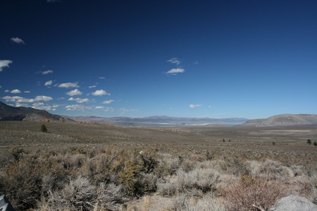
Looking northeast out over Mono Lake, Paoha Island and Panu Crater.

This is what first drew me to Mono Lake - the Tufa Monuments.
We're not talking about bean curd
Call them weird, call them bizarre, call them what you will, but the unusual rock formations that grace Mono Lake’s shores are known to geologists as tufa (too’-fah). Tufa forms in a variety of ways at Mono Lake, but the most visible and remarkable formations are the towers that grace Mono’s shoreline. The greatest concentration of these towers is located at the South Tufa grove just off of Highway 120 East, at the south end of Mono Lake. Many first-time visitors to Mono Lake, unfamiliar with the geologic term "tufa" have been known to ask directions to the "tofu." Your nearest health food store is the best bet, but sometimes the Lee Vining Market will carry it in the summer time.Tufa is essentially common limestone. What is uncommon about this limestone is the way it forms. Typically, underwater springs rich in calcium (the stuff in your bones) mix with lake water rich in carbonates (the stuff in baking soda). As the calcium comes in contact with carbonates in the lake, a chemical reaction occurs resulting in calcium carbonate—limestone. The calcium carbonate precipitates (settles out of solution as a solid) around the spring, and over the course of decades to centuries, a tufa tower will grow. Tufa towers grow exclusively underwater, and some grow to heights of over 30 feet. The reason visitors see so much tufa around Mono Lake today is because the lake level fell dramatically after water diversions began in 1941.
Source: MonoLake.org

In the late 1970s I started getting mailings from the Mono Lake Committee (MLC) about the plight of the lake and surrounding area.
It was in the their newsletter I saw my first photos of the tufa formations at Mono Lake. AlthoughMLC's primary focus was on stopping the water diversions from Mono Lake and halting the dropping of the Lake level; it was the receding water level which had exposed the tufa and turned the Lake into such a unique landscape. A mixed blessing indeed.

This is the South Tufa area. It receives thousands of visitors annually and is one of the largest tufa groves on the lake. It is yet another Fee Area, but the pay station was not open.
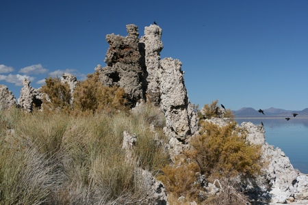
I saw a few gulls on the Lake and some birds on the wing. Mono Lake has always been an important breeding and feeding ground for migratory birds.
Negit Island is an important nesting ground for migratory birds, including the California Gull, which can often be seen wheeling in the air above Mono Lake. The fall of the lake level since 1941 created a land bridge to the island. The land bridge permitted predators, such as coyotes, to raid the bird eggs of the island. However, since 1994, the lake level has been permitted to rise and the land bridge is currently submerged.
Source: WikiPedia
The Awesome California Gull
The shores of Mono Lake offer a perspective of the natural world unique among lakes in North America. Along with stark and lonely tufa towers, the lofty Sierra Nevada to the west, and the corrugated Basin and Range country to the east, there is a thriving ecosystem nurtured by the lake’s conditions. And the California Gull, perhaps the unlikeliest of avian mountaineers, is particularly fond of Mono Lake. This ‘seabird’ spends its winters along the California coast with up to a dozen other species of gulls, where it enjoys the plentiful harvests of fish, marine invertebrates, and abundant refuse from large city landfills. Beginning in March when the reproductive instinct begins to motivate all gull species, most scatter up and down the coast, some north to Alaska and some south to desert islands on the Sea of Cortez, but California Gulls head inland to barren windswept islands on lakes and reservoirs throughout the interior west, from the Great Basin to the Canadian prairies.Source:Justin Hite - The Awesome California Gull
The Wilson’s phalarope is one of the hardiest travelers visiting Mono Lake. About 30,000 to 80,000 of these small shore birds arrive at Mono Lake in mid-summer after breeding in the northern U.S. and southern Canada. While at Mono they molt their feathers and double their weight after several weeks. Leaving in stages in August and September during the cover of darkness, they depart for a journey that takes them all the way to South America. The fact that these birds fly over 3,000 non-stop miles to South America is amazing enough, but what is truly astonishing is how fast these little birds reach their destination— an unbelievable three days!
Source: California Parks

One of the early Pioneers in both bird study and the preservation of Mono Lake was David Gaines.
David Gaines would join David Winkler (the editor of the UC Davis report) and Sally Judy (whom he would later marry) to form the Mono Lake Committee (MLC) in 1978. This grassroots group was able to conduct the research and enlist public opinion to save Mono Lake. The MLC joined with National Audubon Society to bring suit to save the lake, and in 1983 the California Supreme Court agreed that the "public trust doctrine" required LADWP to limit water diversions. It was not until 1994 — some 20 years after David Gaines had first become interested in Mono Lake — that the State set minimum flow limits on streams running into the lake, mandated a minimum lake level, and required habitat restoration. By then, alas, David had died.
In 1974, David inventoried the natural areas of the Mono Basin. The following year "he joined fellow students at Stanford in writing and receiving a grant from the National Science Foundation to conduct the first comprehensive ecological survey of Mono Lake. Their report was published in 1977 by the UC Davis Institute of Ecology. Among the report's main findings was the fact that water diversions from the lake's tributary streams by the Los Angeles Department of Water and Power (LADWP) was a threat to the lake's ecosystems. The diversions had begun in 1941, and had already caused the lake to lose half of its volume and double in salinity. The diversions also caused the lake's Negit Island to become connected to the mainland, allowing predators access to an essential California Gull rookery;" [quotes from "Saving Mono Lake" by Shelly Biswell, Sierra Citizen, spring 2002 issue].
Source: Creagus@Monterey Bay
UC Santa Cruz has established “The David Gaines Award”.
The David Gaines Award was created by his Aunt, Grace Jacobs, to honor his memory. The award, which is for undergraduate or graduate students majoring in Environmental Studies, is given for a field project that will make a significant contribution to the solution of an environmental problem. The award is based on scholastic merit, demonstrated initiative, and feasibility of the project.

Here, and following are a series of photos of the Tufa Towers. Some area 20 feet tall. Keep in mind, if the water level had remained the same, all of these formations would be underwater and still growing. This might give you some idea of the natural depth of the water.


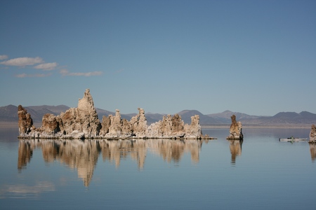
On the right, and nearly out of the frame is a solo kayaker. Seeing him made me wish I had my boat with me.


Navy Beach is next to South Tufa Area, with a short trail connecting them. Due to the proximity of the parking lot to the lakeshore, this is the most popular place to put in kayaks and canoes.
Navy Beach
During the cold war, Mono County was home to one of many remote facilities used by the US Military to test new weapons and weapons systems. A “secret military installation” operated by the US Navy was located along the south shoreline of Mono Lake.During the 1950s and 1960s several branches of the US Armed Forces utilized this test facility to conduct various research. Numerous top secret exercises were actually performed here during what was called “seismic testing.” However, with the expansion of other nearby bases, growing public safety and environmental concerns, this facility soon outgrew its usefulness. In May 1962 all operations ceased and soon thereafter the facility was abandoned.
Although many scientists, technicians, soldiers, and sailors worked at this installation for many years, all that remains today of their activities are a few remnants and the name “Navy Beach.”
This monument and plaque dedicated as a California Sesquicentennial Event.
September 11, 1999
Bodie Chapter #64 E. Clampus Vitus US Forest Service Mono Lake RDSource: Mono Basin Clearinghouse
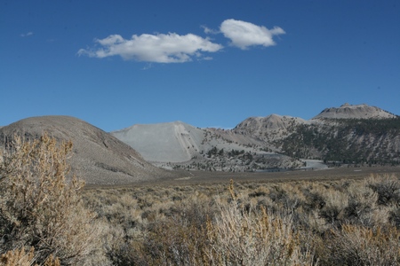
Around 2:00PM I decided to head on over to Mono Lake County Park. On may way back to US 395 I stopped to look at what I assumed to be cinder cones. I was puzzled by the slip on the center cone and wonder what could have caused it.
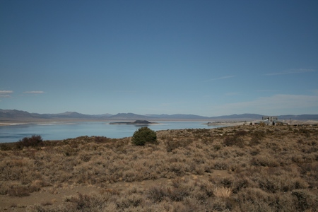
As I drive north on 395 I could see the Mono Basin National Forest Scenic Area Visitor Center and Negit Island.
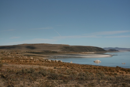
This is an overview of Mono Lake County Park.

Source: © Google Maps
Here you can easily see the County Park boardwalk which terminates in a viewing platform.

One of several signs showing historic water levels prior to stream diversions by the LA Department of Water and Power.
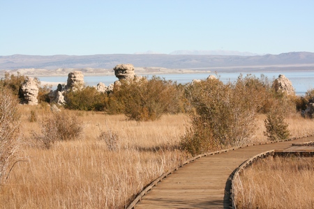
The boardwalk offer exceptional views of the Tufa Towers.

Once again, remember - all this tufa was originally under water.

These massive tufa formations are truly amazing.

When I arrived at the viewing platform there were 4 Brits doing some bird watching.

Looking north back toward the parking area.

A lovely spot to spend a nice sunny afternoon.

Around 3:30 PM I once again headed up 395. I saw more beautiful scenery on the drive north to Bridgeport where I spent the nite.

Thinking back over the day and all I had seen from Lone Pine to Bridgeport, I was, on the this third trip to the area, just as amazed as if it had been the first time.
Next: Sonora Pass Through the Sierras.
