Wednesday, September 19
When my buddy Bruce in San Fran said: "If you decide you want to relive some of your San Francisco experiences - you are welcome to stay here" that got my wheels turning and before I knew it I had jumped on-line and bought a one-way ticket to San Fran. The airline was AirTRAN and the route would be from Pittsburg, to Atlanta and then on to SFO.
The flight was an early departure: 6:40 AM. So Betsy and I drove up to Pittsburg the evening before and stayed in a Motel about 15 minutes from the airport. We left the hotel around 5:20 AM the next morning. After nearly teary good-bye's Betsy sent me on my way to San Francisco.
These photos and commentary tell the story of that first day and the 25 days which followed.
Click on these photos for a higher resolution.
Will be slow with dial-up connection.

This shot was taken just about 10 minutes out of the Pittsburg Airport. The weather had been so beautiful recently I hated to leave. The gorgeous sunrise that morning did not make it any easier to depart.

Flying is not one of my favorite things and generally does not put a smile on my face.

Along with the endless sprawl of the greater Atlanta area I also saw the now familiar patchwork quilt of farm country. I believe this was over or near Arkansas.

This was taken on the approach to SFO. Perhaps the Fremont area?

These settling ponds adjacent to the Bay were used in salt production. They are now dormant and slated for habitat restoration.
South San Francisco Bay Salt Ponds Restoration
San Francisco Bay once supported 190,000 acres of tidal salt marsh, but today only 16,000 acres remain. In 2003, the State of California acquired 15,100 acres of salt ponds in south San Francisco Bay to restore the historic marshes.The Bay Conservation and Development Commission (BCDC) has been collaborating with the California State Coastal Conservancy, other state agencies, NOAA Fisheries Service, non-profits, U.S. Army Corps of Engineers, Regional Water Quality Boards, local governments, neighbors, and many others in a five-year process to develop a long-term restoration plan for the South Bay salt ponds. The project is the largest tidal marsh restoration project attempted on the West Coast. The long-term plan for the salt ponds will outline the mix of habitats to be restored or enhanced and the phasing for implementation of the restoration. The interested parties are working together to determine the mix of different habitat types, from tidal marshes that provide habitat for the endangered California clapper rail and salt marsh harvest mouse to managed ponds which provide feeding and roosting areas for migrating ducks and shorebirds, that will be restored or enhanced. The South Bay Salt Pond Restoration project will also balance the goals of habitat and wildlife protection, public access, and flood control. The South Bay Restoration Plan is scheduled to begin phased implementation in 2009.
The San Francisco Bay Plan contains policies that guide BCDC's management of development, recreation, and restoration activities in the coastal zone. The salt pond policies had not been comprehensively updated in over 30 years. To better plan for this unique opportunity, BCDC revised and developed new salt pond and managed wetland policies for incorporation into the San Francisco Bay Plan. The new policies were adopted in 2005.
Source: NOAA

The San Mateo - Hayward Bridge near SFO. The pilot had mentioned the 30mph winds we would have for our landing. The choppy water verified this.

Here I am on the Air Train platform with my 120 lbs (+ -) of luggage. This is what happens when you take a folding bicycle, bike gear, clothes for 4 seasons, camera gear, a butt pack, two day packs, books, maps and god-knows-what-else. It was interesting trying to manage all of it.
I rode the Air Train to the BART platform. BART is Bay Area Rapid Transit. It now extends from Millbrae, just to the south of SFO, through San Francisco and then crosses the Bay north to Richmond and Pittsburg and south and east to Dublin and Fremont.
Previously I had the luxury of having my brother William pick me up at the airport or I would get a rental car. Not so this time. William has since moved and the first leg of this trip will be carless in San Fran. So I would now have the adventure of getting myself and my luggage through the BART terminals, where everyone, including me, was having trouble getting a fare card out of the machine. Then the ride up the BART line to disembark at the 16th and Mission Station.

The BART train arrived and with the helpful push of another passenger I got my luggage on to the car. Upon arrival at the 16th and Mission station I was greeted to the strum of a guitar and the strong balladeering voice of this minstrel. She had "set up shop" at the base of the elevator. Singing in Spanish, she was a most appropriate welcome to the home of San Francisco's Hispanic population - the Mission District.

I took the elevator up to street level and saw this view across the street from the bus stop. A very typical neighborhood grocery in the Mission, and generally elsewhere in San Fran. It was a welcoming site as I came up out of the depths of the BART station. The corners of 16th and Mission street are a very busy place what with major MUNI line bus stops, the BART station and numerous shops. There is always a hustle and bustle at this intersection.
So, now I am at my bus stop to pick up the 22 line to Bruce's place on Mississippi Street in the Potrero Hill neighborhood. Or am I? Not yet oriented I was uncertain whether this was the correct bus stop or if it was the bus stop catty-corner. I surely did not want to load me and all my luggage on a bus heading in the wrong direction! I decided to ask someone at the bus stop, but I could find out nothing from the 3 non English speakers and the surly FemPunk I queried. One fellow I had asked motioned for me to show my map again. He spoke in Spanish to the women next to him and then they both nodded in agreement. He then said: "Mississippi - yes.", and pointed in the direction the bus was going to take. I thanked him warmly. And when I saw the 22 line to Bay street stop at the other corner I knew I was indeed at the correct corner for my bus.
The bus arrived in about 10-15 minutes. When it did the fellow I had spoken to previously, picked up two of my bags, the two heaviest ones, and motioned me towards the open bus door. We both struggled up the steps and when I got on he had already deposited my luggage on a front seat and was motioning me to take the seat next to the bags. It was hard to convey my thanks and relief for his help but he got the message.
I then went back up to pay the driver. When I asked her how much she said "That's OK" and handed me a transfer. I then took my seat and when I called up to let her know I needed to get off at Texas and 18th she seemed puzzled, then looked back at the women next to me and said: "Does this bus go there?" It was then I realized she was a driver trainee and the women sitting next to me was in a MUNI uniform and was her supervisor. The supervisor assured her (and me) it did indeed go there and the next shift driver would take me there.
When the bus arrived at 16th and Bryant the driver and Supervisor disembarked along with many of the passengers. This is another busy intersection where there is a Safeway grocery store - former site of Seals Stadium, as well as Franklin Square. The regular driver boarded and before he was even behind the wheel he looked at me though the rear view mirror and said: "18th and Texas - they (the driver trainee and supervisor) already told me".
I have to admit, this was not the experience I had expected - getting help from strangers and dealing with friendly bus drivers. But, it sure made my trip into the City much easier and calmed my somewhat jangled nerves.
More about Franklin Square
Franklin Square Park began in 1868, when 4.4 acres between 16th and 17th, Bryant and Hampshire Streets, were purchased for $576,000. Ten years later the Board of Supervisors approved a bill to "immediately borrow $100,000 in gold coin" and park commissioners allotted $12,000 "to immediately grade, fence, plant and improve Franklin Park and conduct water pipes therein." (Alta California, 1878). The park suffered a temporary loss of identity in 1950 when it was renamed Father Crowley Playground after the original Father Crowley Playground at Seventh and Harrison Streets was demolished to make room for the Bayshore Freeway. Subsequently its original name was returned to Franklin Square and the Rev. D.O. Crowley joined other memorable names in Recreation and Park history. (San Francisco City-County Record, 1936).As more families were drawn to the neighborhood and into the park, increased complaints about deteriorating conditions and a lack of recreational facilities for small children were heard. At a public hearing in 1969, the Park Commission was offered a renovation plan by the United Neighborhood Association. Its fate remains unknown.
Franklin Square’s soccer field got its start in an appropriation for construction in a 1984 Commission meeting. In constant and vigorous use since it was built, it was approved for extensive renovation and expansion in 1995. Completed and officially celebrated in January of 2004, the enlarged-to-regulation-size field has a new irrigation and drainage system and state-of-the-art synthetic turf that looks like grass, which outlasts all other varieties and is safer to play on. Games at this “permit only” facility are booked by clubs and schools from all over the area at $40 for 2 hours.
Although city plans recognize the importance of Franklin Square, and although its new soccer field is active and in great condition, the rest of the park deteriorates quickly and is in acute need for renovation. Resulting from years of disregard and insufficient city budgets, the park has been taken over by those who have nowhere else to go and don’t want to be noticed. At present the park serves as home to a large homeless community, prostitution and drug use.
In a February 15th 2006 plan from the city planning department, Franklin Square was identified as one of four “open space” areas to service the entire eastern neighborhoods for San Francisco:
Source: Friends of Franklin Square

When I reached my stop at 18th and Texas I was just around the corner from Bruce's place. When I got to his apartment I let myself in as Bruce was still at work. I started the laborious job of unpacking and organizing the one-thousand-and-one-things I had brought.

Part way through unpacking I stopped for a break and decided to take the fire escape ladder to the roof to catch the view and get some air. The wind was still fierce, even by San Francisco standards, but the sun took the edge off the chill.
This is the view from the roof looking north towards downtown and the Bay Bridge.

After unpacking as much stuff as I could stand I decided to take a look around the neighborhood for a local grocery story and wireless access points. I found the former, but not the latter. The nearest coffee shop, Farley’s at 1315 18th Street, was not going to be the place to surf and upload my webpages.
On the way down the hill I saw the familiar O.J. Simpson Mural. The last time I saw it, in September of 2001, it had "Die OJ!" spray painted across it.
Although heavily faded, this street mural on the side of a furniture warehouse was executed in the late 1980s to celebrate the rich history of Potrero Hill, where Simpson grew up. He played football at Galileo High School and City College before becoming a star at USC and in the NFL. The one-time favorite son is depicted, helmet in hand, near the center of the colossal painting. But, alas, the mural also bears the mark of his fall from grace after he was accused (and, in 1995, acquitted) of murdering his ex-wife and her friend. Simpson's face and torso have been brushed over with blood-red paint, and there are horns above the outline of his head.
Source: SF Weekly.com

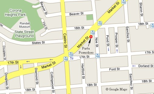
While I was out and about I decided to hoof it up to the Pasta Pomodoro near Market, Castro and 16th a distance of about two and half miles. This took me right past the bus stop I previously been to and the grocery store I had taken a picture of from there.
It is always interesting to see what these markets have, such as the Nopalitos in the first bin. Eaten for centuries by native Americans they are gaining new popularity for both the dinner table and as livestock feed.
OPUNTIA CACTUS
The Farming Opportunity Of The New Century
As Mother Nature takes center stage in the 2000's, farmers in the American Southwest have an opportunity to cultivate a crop which both protects and celebrates the wonders of our precious environment. Unfortunately, this new cultivar-prickly pear cactus-usually seems to be more of a problem than a solution to the sophisticated farmer. However, a look back to the ancient ways of the earliest American gatherers and a look south of the Rio Grande at progressive Mexican farmers has prompted some Texas farmers to reconsider this prickly plant. Beneath the prickly pear's spines lies a plant which thrives in the drought conditions that wither more traditional crops.The tender, juicy cactus leaves are a tasty, nutritious food for the American table, as well as succulent forage for the cattle and the wildlife which suffer in the summer's heat. The prickly pear (Opuntia) cactus is a native plant that knows the ways of our land. It can beautifully adorn our lawns and effectively reclaim our damaged land without making unbearable demands on precious water supplies. This cactus also offers natural dyes and bases for those in the cosmetics and clothing industries seeking alternatives to artificial substances.
A choice to cultivate the Opuntia cactus is a choice to work in harmony with nature and a choice to meet the demands of the 2000's for foods and products which enhance health without squandering resources. Those who share this emerging vision will find that just as the thorns guard the beauty of the rose, the threatening spines serve only to protect the secret wealth of the Opuntia cactus.
Source: The Texas Cactus Council

I passed several used book stores on my way up to Market Street and stopped when I saw a bargain rack at Forest Books (near Valencia St). A bargain rack cannot be ignored so I took a look though the offerings and found this book for 2 bucks.
It was published in 1971 and illustrated with both black and white and color sketches by the author. I thought it might come in handy on my road trip so I bought it.

As I continued west on 16th Street I walked by the historic Mission Dolores which lies between Chula Lane, Dolores, Church Streets. This is one of several entrances.
Mission San Francisco de Asís is the oldest surviving structure in San Francisco and the sixth religious settlement established as part of the California chain of missions. The Mission was founded on June 29, 1776 by Lieutenant José Joaquin Moraga and Father Francisco Palóu (a companion of Father Junipero Serra), both members of the de Anza Expedition, which had been charged with bringing Spanish settlers to Alta (upper) California.
History
The settlement was named for St. Francis of Assisi, the founder of the Franciscan Order, but was also commonly known as "Mission Dolores" owing to the presence of a nearby creek named Arroyo de Nuestra Señora de los Dolores (Our Lady of Dolores Creek), or "Stream of Our Lady of Sorrows." A member of the Anza Expedition, Friar Font, writes about the spot chosen for the Mission:"We rode about one league to the east [from the Presidio], one to the east-southeast, and one to the southeast, going over hills covered with bushes, and over valleys of good land. We thus came upon two lagoons and several springs of good water, meanwhile encountering much grass, fennel and other good herbs. When we arrived at a lovely creek, which because it was the Friday of Sorrows, we called the [creek] Arroyo de los Dolores ... On the banks of the Arroyo ... we discovered many fragrant chamomiles and other herbs, and many wild violets. Near the streamlet the lieutenant planted a little corn and some garbanzos in order to try out the soil, which to us appeared good."
The original Mission consisted of a log and thatch structure dedicated on October 9, 1776 after the required church documents arrived. It was located about a block-and-a-half east of the present Mission, near what is today the intersection of Camp and Albion Streets, on the shores of a lake (long since filled) called Lago de los Dolores.
A historical marker is currently placed at that location. The present Mission church was dedicated in 1791. It was constructed of adobe and part of a complex of buildings used for housing, agricultural and manufacturing enterprises (see architecture of the California missions). Though most of the Mission complex, including the quadrangle and convento, has either been altered or demolished outright during the intervening years, the façade of the Mission chapel has remained relatively unchanged since its construction in 1782–1791.
Source: WikiPedia

This amazing ceramic tile mural caught my eye - how could it not!

My destination, the Pasta Pomodoro. This is a local chain with good pasta and reasonably priced meals considering the locale. The menu and prices have changed significantly since I was there in 2001. There are now a dozen or so stores in the Bay area.
Since 2001 they have made a conscious effort to project a more upscale atmosphere with a fancier web site, menu, and ad campaigns. I think the place is getting too big for it britches, but that is the price of success.

When I entered I saw only one occupied table and they were just finishing up their meal. It was about 4:00pm PST now, but to my stomach it was 7:00pm EST and I was more than ready to eat.
I was greeted by a bouncy, smiley 20 something who invited me to sit anywhere, which I did.

I started out with a small "Mista" salad made from organic lettuce, roma tomatoes, carrots and topped with gorgonzola and balsamic dressing. $3.50. Along with it came some nice crusty bread and a pesto dipping sauce.

Next came the Pomodoros version of spaghetti and meat balls: Pasta with a veal, a hefty beef and Italian sausage meat ball in a spicy tomato sauce. $7.25.
The Miller Lite was ridiculously priced at $3.75. Next time I will stick to water.

After supper I headed back down 16th street. This is looking down 16th from Market Street. The distant spire on the right is the Mission Dolores.

There always seem to be the ancient vehicles scattered around San Fran. I wonder how old this one was.
This one remined me of the 1968 IH D1200 PU which the family purchased in 1972. It was used to transport us and our belongings from 2381 Bush Street in San Fran to a farm in Greenbank, West Virginia. Now that was an Epic Road Trip!

Detail of the mural I passed earlier on 16th near Sanchez. Click on this (and all photos) for a higher resolution image.
It was originally painted on a fence on 16th Street, in 1992, by Colette Crutcher, for Instituto Pro Musica de California. Title at that time was "La Madre Tonantsin" as the mural depicts Tonantsin, the indigenous Mother Goddess of Mexico. In 1998, Colette restored the mural using different technique, as well as different materials. The new mural, called "Tonantsin Renace" (Tonantsin Reborn) is done in cast fiberglass resin, with mosaic work and metal inlay. It is absolutely breath-taking.
Source: Patricia Rose of Precita Eyes Muralists Personal communication, 2008

The murals' headpiece says: "'Tonantsin Renace' is a gift to the people of San Francisco from Colette Crutcher and the Instituto Pro Musica De California. This mural is dedicated to all those who work to preserve the cultural heritage of Latin America. Special thanks to the Gaffneys for commissioning this work. For mural information call 641-1987."
Photo by: Matthew Lasar of sfMurals.com
Matt's site is a must see for anyone interested in murals.

San Francisco has a lot to interest any student of architecture. Along with thousands of wood frame Victorians there are a number of fine old brick buildings like this one at Kansas and 16th Streets.
It is a wonder any of them have survived the numerous earthquakes which have plagued the area.
This particular building houses a taqueria, tile showroom and Blue Marlin Corp.

Blue Marlin Corp
If it's hot enough for The O.C. and the likes of Paris Hilton, who's going to argue? Blue Marlin designs, makes, and distributes high-end sportswear apparel for men, women, juniors, and children.The company's popular track jackets (often emblazoned with city names across the front) have been seen on Fox's television series The O.C., as well as on the backs of many a celebrity including the scandal-prone Hilton heiress who brought new meaning to the word "hot."
Blue Marlin's T-shirts, sweatsuits, hoodies, hats, and jackets are sold through department stores and specialty retailers (Bloomingdale's, Nordstrom, Barneys New York) in the US, Europe, and Japan.
Source: Answers.com

This final shot of the day, a few blocks from Bruce's apartment gives a glimpse of the downtown area. The elevated tank on the left is the site of Anchor Brewery at 1705 Mariposa. They are famous for their Steam Ale. I had hoped to tour the brewerey but never got around to it.

In 1896, the year Ernst Baruth and Otto Schinkel, Jr. named their brewery Anchor, there were more than two dozen breweries in San Francisco! Amazingly, Anchor—and only Anchor—survived.
Anchor Steam derives its unusual name from the 19th century when "steam" seems to have been a nickname for beer brewed on the West Coast of America under primitive conditions and without ice. The brewing methods of those days are a mystery and, although there are many theories, no one can say with certainty why the word "steam" came to be associated with beer. For many decades Anchor alone has used this quaint name for its unique beer. In modern times, "Steam" has become a trademark of Anchor Brewing.
Source: Anchor Brewing Company
Day 1 - FINIS