Tuesday, August 23rdth 2011 (Wyoming)
In June of 1997 Betsy and I took what I know refer to as "The Iowa Road Trip". This trip had it's genesis with the transplantation of my brother Bill/William/Yinks from San Francisco to, of all places, Fairfield, Iowa.
Like many folks I had the stereotyical image of Iowa: flat, boring and nothing but cornfields. So when Brother Bill told me he found the town of Fairfield to be a nice little place to live with and interesting downtown, bike path, nice parks and the icing on the cake: The Maharishi University of Management, I just had to see it for myself.
So, Betsy and I hatched plans for a road trip which would take us via all back roads to Fairfield and then as far west as Golden, Colorado. Just by chance we ended up in the Medicine Bow National Forest on that trip.
Below are some excerpts from the journal Betsy kept on that trip.
6-18-97
We reorganized the car & left Denise's (in Golden) about 10:00 a.m. First we went to King Sooper for groceries (which included a package of sushi from the deli) then we gassed up & headed north. Although we had originally planned to stay in Rocky Mountain National Park or the surrounding first service area, we ended up going farther north & crossing into Wyoming and Medicine Bow National Forest. We stopped at Boswell Creek Camp Ground & decided that was the place for us. Eight lovely wooded, widely spaced campsites. We chose one from which you could hear the burbling of the creek & set up camp. Only one other site was occupied that night.Not long after we were set up it began to rain & hail, so we retreated to the car with beer & wine. When we realized it was not going to let up in the near future, we decided to take a drive. We took a gravel/dirt road that hooked up to 230 in 7 miles. In several places, the road became a red, wet clay/powder surface which was almost impossible to drive on.
We inched along, trying not to slide off the road & breathed a sigh of relief when we reached the hard top. Since it was still pouring rain, we decided to stop and have our supper at the Woods Landing Bar & Café. It was quite a quaint old place, with some local characters and a dance floor supported by box car springs! We talked with the older man next to us at the bar as we ate.We got back to the camp ground shortly after 8:00, had a lovely quiet fire & went to bed.
P.S. There were lots of mosquitoes!!6-19-97
We got up about 6:30 to a beautiful clear, blue sky morning. After coffee & sweet rolls, we headed out for a walk down the road. The scenery was absolutely gorgeous-aspen, pine, sage brush, tons of wild flowers & beautiful back roads running everywhere. We hiked for about 2 hours, then came back for breakfast after which I laid down in the tent & read-troubled tummy.After noon we drove out & found a cross country ski trail to hike. (This is where I found the hand made ski hat which I cherish and still wear today. - mb) It was an OK hike but not as nice as the morning. We came back for beer, munchies & supper, then headed out for our evening walk on which we identified a broad tailed humming bird.
Our evening campfire was accompanied by the sights & sounds of an approaching thunderstorm, but it never really hit us, so we're still sitting here enjoying the fire and the increasing twilight. We both agree this is one of the nicest campgrounds we've stayed in!
6-20-97
We left Boswell Campground around 8:00 a.m. Another beautiful morning & we hated to leave, but the mosquitoes were waking up fast, so we hopped in the car & off we went.We saw many pronghorn antelopes as we drove along and once we saw a fawn nursing. The terrain was ever changing, flat to hilly, scrub, wild flowers, rocks, and all with a wide blue sky with fantastic cloud formations.
The "Iowa Road Trip" was one of our best ever and I remember it fondly. So, how could I resist re-visiting that little campground and funky bar? I couldn't. So on Tuesday morning I set out for Woods Landing to take a look around.
Click on the photos below for a larger image.

A short 23 miles down SR 230 and I was at Woods Landing, home to the now legendary "Woods Landing Dance Hall".
I was disappoingted to find the place closed but when I heard voices from within I knocked on what turned out to be the door to the kitchen and opened the door. There was a gentlemand just inside on the phone and he motioned me to wait a moment. Shortly he was off the phone and asking how he might help me.
I introduced myself and told him about how Betsy and I had stopped here in June of 1997. It turns out that he had just bought the place the year before so he was the proprieter when we were there. We talked for a bit then I asked if I could go inside and take some pictures and he told me to take as much time as I needed.

The place looked exactly the same to me, alhough I don't remember the pool table being there in '97. The bar is where Betsy and I sat with our beers and burgers and chatting to an old timer who was sitting next us.
It was certainly a welcome place to hole up on that windy and rainy evening.

Here is the background - or some of it. I was to lazy to transcribe it so click to get the bigger image and read it.
More, from the Woods Landing website:
In 1883 Col. Sam Wood started out with his family in a Conestoga wagon from Atlantic, Iowa, to come to Wyoming Territory. At the foot of the Medicine Bow Range, he staked out a house site on the Big Laramie River and built the first house, the site that now bears his name.
Woods Landing became a welcome spot for freighters and stage drivers, and the saloon Sam Wood opened beside the river became a popular place for the scores of tie hacks in the vicinity. Ties cut and hewn in the mountains were floated down river to Laramie during the spring run-off and the woodsmen celebrated the end of the tie drive at the riverside saloon.
In 1927, a young Indiana couple, Mayne and Clarence Lewellen, who had come west to find a cure for Clarence's tuberculosis, bought the property and began development of what is today's Woods Landing Resort. They hired a stalwart young Norwegian, Hokum Lestrum to build a dance hall, which was constructed entirely of hand-grooved logs (with no nails). The hall was built on top of 24 boxcar springs and even today is reputed to be the best dance floor in southeastern Wyoming.
The dance hall was placed on the National Register of Historic Places in 1986.Source: Woods Landing Resort
With that I said "Farewell" to Woods Landing and hoped the next time I was back this way I would be sitting at the bar and having burgers and beers with Betsy.

This is the Laramie River which the green way follows in the city of Laramie. Very scenic out here it the country. I crossed the river and now I was heading into the countryside in search of Boswell Creek Campground.

These next few photos were taken on Route 10 just outside of Woods Landing.
Near as I could tell those snowy mountains in the distance are somewhere down in the Rockies of Colorado.

Looking back along Rt 10 towards Woods Landing. Very typical southern Wyoming country side - sage brush and prairie grass.

Seems like it is always windy in Wyoming, and that includes the winter time. And, it does not take much windblown snow to close a roadway. These snow "fences" help control that.

These are 12' high.
About 9 miles from Woods Landing is the site of the old Boswell Ranch. This is the place where the last man in Wyoming was hung - for stealing a horse, or so I was told. I have not been able to verify that. I did check I. S. Bartlet's "
History of Wyoming", but turned up no information.
This fellow, whoever he was, is not to be confused with the last man to be hung in Wyoming. That was Tom Horn. He was hanged in 1903, on September 20th, the day before his 43rd birthday - for murder.
Anyway, I got distracted - it is at the Boswell Ranch where US Forest Service route 526 intersects and heads west towards Boswell Creek.

This is US Forest Service route 526, the one Betsy talks about above. That evening in 1997, on our way to Woods Landing, the dry, powdery clay surface had turned into a brown slippery mess in the rain. It was like trying to steer on ice and the mud clung to the tires and clogged up the wheel wells. I was sure we were going to end up in the ditch or worse yet, over the hillside. But, we made it without incident.

The road climbed up out of the Laramie River valley...

...and into a nice stand of Trembling Aspen.

When I got into a dense, mostly beetle killed stand of Lodgepole Pine I suddenly started seeing all kinds of people wandering around in the woods. Some of them were doing what this guy was - digging stuff up.
I pulled off the side of the road and asked one of the metel detector wielders what was going on as was told to ask the lady in charge - Kolleen Kralick, Forest Archaeologist. She told me they were tracking the route of the Pioneer Trail through this section of the Forest.

No one was immediately sure what this piece of metal was.

But, everything found was being carefully described and catalogued.

One of the things they had found was this shotgun shell. It is a LEADER Trap Load Shot Gun Shell. I didn't think much of it but apparently it was unusual in that it had a copper base and they were only used for a 4 year period. This made it easy to date it.

This box sold on Ebay for $6,157.00 at Aug 22, 2011!

Kolleen's son was with her and found something which folks wanted to see.

The kid didn't know it but he was being shot from both sides.
I said "so long" and continued on down FS Route 526.

Unfortunately, this was a typical scene for miles and miles along the road. It is going to be a monumental job clearing out all the dead trees so they do not continually block the roads as the fall.

Well, here it is - what is left of Boswell Creek Campground. The "Eight lovely wooded, widely spaced campsites." were now bare to the sun or peppered with dead and dying pines. And, the campground was now closed - or, " decomissioned" as the Forest Service calls it. But " dispersed camping" is still allowed and you can see a tent in the background.

Boo-hoo...

This is all that remains of the whispering in the wind sound and cooling shade of the camp site's pines.

The solid, squat fortress of an outhouse is still in good shape. I took a peek inside and it was clean and someone had hung a garbage bag up on a hook. Also, the water pump seemed to be in good shape as well. So, coming back here to camp someday may still be in our future.

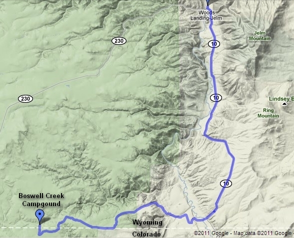
The route from Woods Landing to Boswell.

It is hard to visualize now but these road banks were covered with wild flowers when we were here in June of '97.

Bye-bye, Boswell...

A short ways down the road is "Ox Yoke Ranch". For a moment I thought I have been mysteriously transported back to some "squaller holler" in West Virginia. Well, at least there wasn't trash laying about everywhere.

This is just outside of Mountain Home near Wyocolo. Considering the millions of dead standing trees there is going to be way more biomass than anyone can possibly use.

At Mountain Home the Medicine Bow Rail-Trail crosses. Here I parked the van, got out my lawn chair and ate a peanut butter sandwich. The prospect of riding down this hot and dusty trail did not seem to appealing so I moved on.

This is the trail head at Rt 230 and USFS road 898 (Pelton Creek Road). Of course there is the obligatory $5 day use fee.


There is currently only about 23 miles of developed trail but more must be in the works.
I drove on down Pelton Creek Road hoping to find the trail head for "Castle Rock". It was about 9 miles to the TH and the campground there.

Still more dead pines. I still could not believe the numbers I was seeing.

Hopefully this little feller on the left will survive, grow and cast it's seed far and wide.

When I got to the Pelton Creek Campground the first thing I saw were these camp sites closed due to "hazard trees". Most sites were open and all were unoccupied.

The campground sits right on the boundary line for the Platte River Wilderness.

This is the view from the campground across Pelton and Douglas Creeks. Almost the entire hillside is dead.

Lovely little Pelton Creek which I had to ford, along with Douglas Creek, to get the Castle Rock Trail.

The trail hugged the ridge and went through Sage and young Lodgepole Pine.

Here is a shot of Sage Brush and a plant which has my favorite Latin binomial - Arctostaphylos uva-ursi, or Bearberry. This plant has a very wide range - from Alaska to the Appalachians and lots of places in between.

The beautiful " Mother Sage". I love it.
About this time I realized I was going the wrong direction on the trail - downstream instead of upstream. I backed tracked and walked a while in the right direction but soon wilted in the mid-afternoon sun and headed back to the van.

I drove back up Rt 230 and saw more salvaged pines - lots more.
Then it was down the long, winding grade to Woods Landing and back to Laramie where I enjoyed the early evening sun in the company of a few beers.
Tomorrow I continue on westwards to Logan, Utah.