03 February 2013
Super Bowl Sunday - when millions of people huddle around the TV whooping and hollering and eating and drinking vast quantities. Sounds like the perfect day for a hike up in the Torts!
Over the years I have often heard the "Tortolitas", aka "Torts", mentioned by fellow hikers. What was being referred to was the Tortolita Mountains, an area about 25 miles to the north of Tucson. Last year I finally got up there for a look/see. And boy - am I glad I did.
Compared to the other local mountain ranges I was familiar with: The Tucsons, Catalinas, Rincons and Santa Ritas, the Torts are in a class by themselves.
You will find no granitic domes or jagged, red rock lava spatter here. Instead you will find a boulder strewn landscape which defies description. And even though the photos below may be worth the proverbial "thousand words", they don't come close to depicting the unique beauty of the Torts.

So close, and yet so far. At least that's what it seems like when I talk to long time, seasoned hikers who have never been there. Ahhh... if they only knew what there were missing.

A closer look. The main trail access is near the mouth of Wild Burro Canyon. This is also home to The Ritz-Carlton at Dove Mountain a lavish, beyond upscale resort.
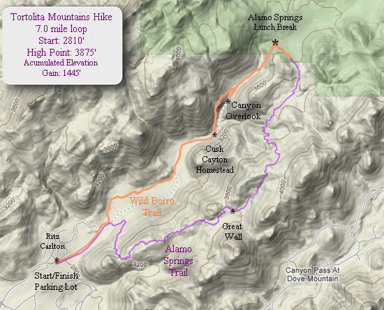
Our route.
The distance and elevation belied the effort required - at least for Betsy and me.
For years I had myself convinced the name "Tortolita" has something to so with tortoises. Not so...
Tortolita—meaning of the name:
Tortolita Mountains is from the Spanish and means "little turtle dove." Part of the short history/description of the Tortolita Mountains: "this is the same locality which Font in 1775 called Llano bel Azotado (llano=plain; azotado=a flogged man) because on the plain near these mountains a deserting muleteer was caught and flogged. In 1880 they were called Bloodsucker Mountains. The current name, as was noted in 1916, derives from the fact that there were multitudes of small doves here prior to 1916."
Source: Granger, Byrd Howell. Arizona's Names: X Marks the Place. Tucson, Ariz.? Falconer Pub. Co.: distributed by Treasure Chest Publications, c1983.Source: Source: Pima County Library
Click on the photos below for a larger image.

Betsy and I arrived at the trail head parking lot around 10:30.
The trail starts in the adjacent wash and meanders back and forth up the canyon.

The canyon looks like one huge boulder pile.

A preview of things to come.

The level, packed sand trail made for easy going hiking.

Some sections of the wash trail are in loose sand.

This looked like a rocky backbone to me.

What the...??!! Yep, it's just what it looks like. An old swimming pool.
In 1926, Eugene "Cush" Cayton left Missouri for Tucson seeking to improve his health. On the advice of a local surveyor, he purchased a choice piece of Ruelas Canyon in the Tortolita Mountains and established the T Bench Bar Ranch. The surveyor predicted: "One of these days this land will be one of the most beautiful spots in the Tucson area."
It is now known as Dove Mountain. Cush and his family ranched the land until 1984. They were gracious hosts, entertaining a wide variety of artists, scientists, prospectors, cowboys and assorted colorful characters over the years. They passed their stewardship on to David Mehl, a choice they made with loving and thoughtful consideration of the land.Source: ©2010 - Dove Mountain

All that remains of the Cayton homestead. Nearby there is a concrete livestock tank, but that is all we saw.
Just as we were about to head up the trail which took us up out of the canyon, Betsy looked down at the ground and asked: "Is that a mushroom?". Indeed it was.

I tapped the cap and millions of spores were released. Nice color.

The trail section from the old ruin starts with a steep, rocky climb and stayed that way until we got to the Canyon Overlook.

The short spur to the overlook is definitely worth taking. You will scramble over huge boulders polished smooth by eons of running water and all the particulates it carried.

Looking back down Wild Burro Canyon we could clearly see the ribbon of sand we had just hiked up.
The day was cloudy which was a nice change. But I found it made getting decent landscape shots almost impossible

Evidence of the recent rains. Are those white bands quartz intrusions? There's never a geologist around when you need one...

We found the nice smooth rocks a good place for a rest stop. From here we could hear the lovely call of the canyon wren - and nothing else. Heaven...

This is Bubba. He was out hiking too. I think he and Betsy might be related somehow.

Considering the rugged terrain and hard packed soil, the trails are most excellent.

We have now arrived at what I call Alamo Springs Basin. When I first hiked this trail last year I was taken aback by what seemed like the sudden appearance of this open, flat area. After hiking up the canyon it made for quite a contrast. What a great spot for lunch!

I cannot recall ever being on trails as well marked as these. Hats off! to the designers and builders of these trails.

This memorial bench makes a nice place to stop and take in the view. Here, as with most of the hike, we saw hardly a soul.

Now that we have gained some elevation the vegetation has started to change and we saw many fine, old specimens of Sotol (Dasylirion wheeleri).

The Alamo Springs trail - our route back, has many fine views like this one.

This close-up of the Banana Yucca (Yucca baccata)clearly slows why the indigenous people used the leaves as a source of fibre for weaving.
The fruits of the Banana Yucca are fleshy and banana-shaped and when baked have a taste reminiscent of a sweet potato.

This headless and wounded Saguaro is making a valiant effort to survive. It has no less than nine buds sprouting from this one arm.

These rock formations were quite beautiful. I cannot remember ever seeing a place where the hillsides were composed of nothing but thousands of boulders.

The needles on this cactus are no protection from being shredded by Javelinas.
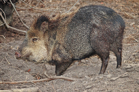
Photo Source:WikiPedia
Javelinas are common in southwest Arizona. They are not pigs or boars but are Collared Peccaries. Other species of peccaries can be found in Central and South America.


Photo Source:TucsonCitizen.com
Why does an herbivore have such big canine teeth? These big teeth serve three purposes. The most obvious is defense. These large canine teeth can inflict serious injury. The large teeth also are used to shred cactus pads. Lastly, the canine teeth help stabilize the jaw when the javelina is trying to crunch something very hard like a mesquite bean.
Source: TucsonCitizen.com

The Tortolita Mountains have many fine specimens of Saguaro.
We also came across Rambo's kid sister.

The growing end of a Saguaro arm.

All that remains of a long dead Mesquite and Saguaro.

Although there is nothing for scale, that opening was big enough for me to crawl through - but I didn't.

Here we approach the "Great Wall".

As they say "You had to be there". This photo gives not an inkling of the size and beauty of The Great Wall.

A boulder jumble at the base of the Great Wall.

The west end of the Great Wall. That's a Teddy Bear cholla in the foreground.

Up and down and up and down and up and down.... We were plum tuckered out at the end of this hike!

Boulders, boulders and more boulders. It was quite beautiful.

Now we are back on the front side of the Canyon. Here is a good look at the wash we hiked up.

Seeing bare ground in a wash is fine. Seeing it here - no so much. Apparently there are some more buildings going up down by the Ritz.

There was a short spur up to a point which afforded us some great views.

I had a tough time keeping up with Rambina!

The obligatory artsy shot.

One last look before we dropped back down to the wash.
What a great hike!
'Till next time...