Mike Breiding's Epic Road Trips: November ~2019~
The Roof of the Rincons
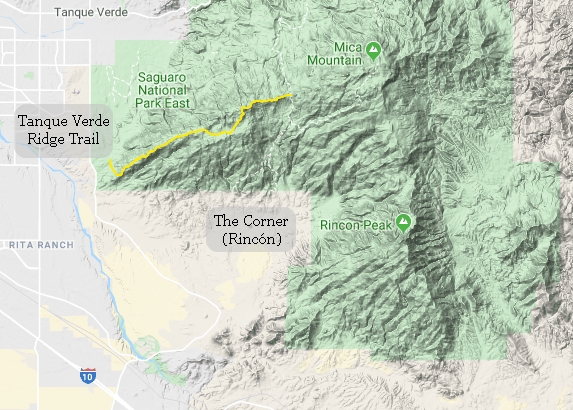
Hiking the Tanque Verde Ridge Trail to Tanque Verde Dome
November 15th and 26th 2019
The Roof of the Rincons:
Hiking the Tanque Verde Ridge Trail

Considering it is an hours drive to any of the trail heads in the Rincon Mountains we have not spent much time hiking there over the last 8 winters. That is changing with this winter. It's either make the drive across the Tucson basin or don't hike in the Rincon Mountains. So - we drive and we hike. And we are glad of it.

Here is a silhouette of the Rincon Mountains as seen from Tumamoc Hill on the west side of the Tucson basin.
The isolated and prominent nipple peak on the right is Rincon Peak (8,482'). Somewhere on the left is the high point in the Rincons - Mica Mountain (8,664').
BTW - Rincon is Spanish for corner, denoting the primary shape of the mountain range.
Click on the photos below for a larger image.
November 15th 2019
Part I - Hiking with the Robust Elderlies

Today we are taking a Baby Hike - just shy of 6 miles round trip. But, we will have significant elevation gain - at lease for us!

The hikers today: Kathryn, Betsy (above) Mark,Kathy and myself.
The lower Rincons are famous for their jumbo Saguaros and rightly so.

Mark dutifully signed us in. On this one sheet: Seattle, Tucson, Avon MN, Anchorage, Acme MI, Kelowna BC, Colorado Springs and Emery SD. I guess we should add Morgantown WV to that as well.

It was not long before we started gaining elevation and enjoying the ever changing views as we climbed.

Today's hike would be a rocky one from start to finish.

Yes this is the trail. But it is hard to discern from this perspective.

The Robust Elderly.
Note all the Ocotillo.

As we gained elevation the vegetation changed. The Saguaros thinned out and were replaced by mesquite, Dasylirion, lechuguilla (shin dagger), upland cotton, turpentine bush and some scrubby oaks.

The vegetation was thick and close on some sections of the trail. Check out those Dasylirion flower stalks. Amazing!

On the left we see Tanque Verde dome.
This was the last shot for this hike. Having never been on this trail before Betsy and I knew we would be back soon.
November 26th 2019
Part II - Hike To Tanque Verde Dome
After our wonderful hike on the 15th, Betsy and I were eager to get back. I was particularly interested in seeing if we could get up on top of Tanque Verde Dome as I knew the view would be spectacular. I also wanted to get a GPS track so I could more accurately state the distance and AEG when I posted it as a led hike for our Hiking Tucson MeetUP group.
On today's hike we were starting at a later time so there was no need to leave the house at 6:00am like the last time.

This set of photos in Part II were taken using my phone. Why? Because my camera had crapped out just a few days prior and I had not yet done anything about replacing it. I was pleasantly surprised at how the photos turned out. The only change I made to the settings was to under expose all the shots by about 3/4 of a stop. I have been doing this for years with my point and shoot digi cams. It has the effect of saturating the colors and adding a bit more contrast to a shot.

Here the Catalina Mountains are laid out before us and there are saguaros as far as the eye can see.

Looking west to the Tucson Mountains - our back yard.

Rocks, rocks and more rocks. Sorta like the Tucson Mountains. But these of the Rincons are markedly different in their weathering patterns and colors.

Rugged beauty! Cute too!

There were lots of prickly pear cactus on the slope and all the way up to the Roof.

There is nowhere else on earth I would want to be in the winter. Betsy...? Maybe a beach trip or two as well to make for a perfect winter.

We are now up above 4000' and the saguaros have stopped their march of the mountain. Now we are surrounded by Dasylirion, ocotillo, prickly pear with a few agave like this Palmer's century plant shown here.

We made it! Tanque Verde Dome made for a nice lunch break and had the views we thought it would. That's the Catalina Mts in the background.

The Tucson mountains look pretty small from this distance. And compared to the Catalinas or Santa Ritas - they are.

Not much distance but a bit of climbing as you can see.

Rincon peak - still looking quite distant.
From this point the Tanque Verde Ridge trail continues on for another 7 miles to where it intersects with the Douglas Spring and Cowhead Saddle trails. Before it gets to that point it passes through the Juniper Basin Campground and Tanque Verde Peak (7,049'). A hike to the summit of Tanque Verde Peak requires an 18 mile round trip with 4000' of net elevation gain. Certainly out of our reach!
And "Tanque Verde"? What's that all about? Translated from the Spanish it means "Green tank". Tanque or tank is used commonly in these here parts to denote a watering hole, man made or otherwise.
Tanque Verde began as a small community, remote from Tucson, and settled by ranchers arriving to the American West around the 1860s. The name of the area, which means "green tank," is a reference to the algae in a large and prominent stock water tank in the area in the late 19th century.
Source: WikiPedia

Where's the trail!? It is mostly obvious when crossing the big rocky areas. When it is not there are usually cairns to keep you on the right path.

Let's talk about mica.
The Rincon Mountains are one of many relatively small ranges that dot the southwestern U.S. belonging to the Basin and Range Province. These ranges are the result of block faulting which occurred 10-25 million years ago (MYA) and are separated by basins filled with thousands of feet of alluvial sediment derived from the erosion of these mountains.
The Rincon Mountains are a highly eroded mass of bedrock referred to as a metamorphic core complex, one of several that extend from northern Mexico into southern Canada.
The highest peak in the Rincons is Mica Mountain. It is 8666’ in elevation and supports Ponderosa Pine and spruce vegetation. Several trails lead to its summit, including one along Tanque Verde Ridge, the portion of the Rincons visible from park headquarters.
Source: NPS
For much of our hike today we saw many small flakes of mica. I am sure there are millions of such flakes on the surface. They are shiny like glass and reflect the light. So much so one can stand in the Tucson basin look up at Mica Mountain and be sure they are seeing snow. But most of the time it is the sun reflecting off the mica flakes. Of course in the winter these flakes just might be covered with snow. So, it can trick ya!
I first heard the word mica when I was a kid. We had a small gas space heater which had mica "windows" in it so you could see the flames from the burner. I was fascinated with this stuff and kept picking at one of the panes until I got one out. I was amazed how it could be bent and somewhat twisted without breaking. And if you used your finger nail you could separate very thin pieces off of it. Needless to say my curiosity was not appreciated and fortunately the mica sheet could be put back in place.
At one time mica was used in place of glass.
..it could compete with glass which had to be imported from England with all the associated dangers from breakage and unpleasantries of greedy custom officers and their import duties. For the non-believers: A very large piece of about 1 meter high can be seen in the Smithsonian Museum in Washington.
Mica is amazing stuff. Check out some of its properties.
The crystalline structure of mica forms layers that can be split or delaminated into thin sheets usually causing foliation in rocks. These sheets are chemically inert, dielectric, elastic, flexible, hydrophilic, insulating, lightweight, platy, reflective, refractive, resilient, and range in opacity from transparent to opaque. Mica is stable when exposed to electricity, light, moisture, and extreme temperatures.
The word mica is derived from the Latin word mica, meaning a crumb, and probably influenced by micare, to glitter.
Source: WikiPedia
The mica group of sheet silicate (phyllosilicate) minerals includes several closely related materials having nearly perfect basal cleavage. All are monoclinic, with a tendency towards pseudohexagonal crystals, and are similar in chemical composition. The nearly perfect cleavage, which is the most prominent characteristic of mica, is explained by the hexagonal sheet-like arrangement of its atoms.
Source: WikiPedia

Mica may be said to have "nearly perfect cleavage" but this is what I think of when I hear those words!

The last shot before we started the hike back down off the Roof of the Rincons.
Me thinks we shall soon return.
See you next time...
Mike and Betsy
~~~~~~~~~~ BONUS Photo ~~~~~~~~~~

Our 27th Anniversary photo - May 15th 2009.