port·age (pôrtj, pr-, pôr-täzh)
n.
1.
a. The act or an instance of carrying.
b. A charge for carrying.
2. Nautical.
a. The carrying of boats and supplies overland between two waterways or around an obstacle to navigation.
b. A track or route used for such carrying.
To transport or travel by portage: canoed and portaged the goods; portaging around the rapids.
[Middle English, from Old French, from porter, to carry, from Latin portre.]
08 July 2014
Although it would not surprise me to be walking a well worn foot path frequented by traveling members of the Great Lakes tribes I did not expect the same path to have been traveled by the likes of Daniel Greysolon Sieur du Lhut and Henry Schoolcraft. But such was to be the case on this day.
This path is the portage between the Bois Brule and St Croix Rivers which provided the shortest water route between Lake Superior and the Upper Mississippi River. Indians used it first, then French explorers and fur traders found this portage of great use as well.
Here are a couple of maps to help with orientation:

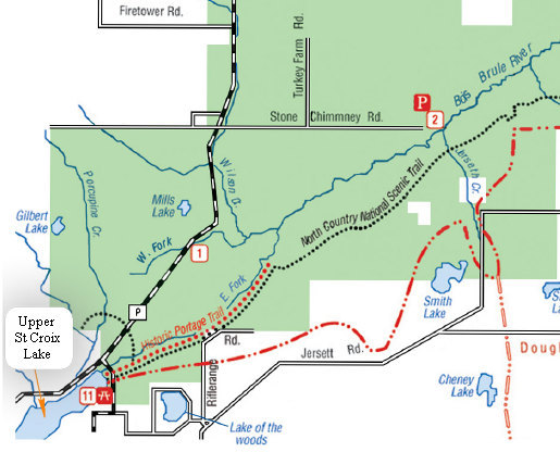
If you look at the lower left hand corner of the DNR maps you will see the dotted line labeled "Historic Portage Trail". Just where the word "Trail" is, you will see a break in the blue line which represents the juncture of the Bois Brule and St Croix Rivers.
The Brule River, which drops over 420 feet in elevation on its 44 mile journey, runs north to Lake Superior and St Croix south to the Upper Mississippi River.

Here is yet another map to illustrate the location of the Bois Brule and St Croix Rivers. Note the city of Duluth. It was named after a famous French explorer by the name of Daniel Greysolon Sieur Dulhut .

Here is the entire run of the Brule River as depicted on one of the most excellent road signs.
At the bottom of the photo is a line for the Laurentian Continental Divide.
The Laurentian Divide or Northern Divide is a continental divide in North America dividing the direction of water flow in eastern and southern Canada and the northern Midwestern United States. Water north of the height of land flows to the Arctic Ocean by rivers to Hudson Bay or directly to the Arctic.
Water south of the divide makes its way to the Atlantic Ocean by a variety of streams, including the Great Lakes and Saint Lawrence River to the east, and the Mississippi River to the Gulf of Mexico to the south.Source: WikiPedia
BONUS: Edward Marek's trip report "Tracking the Brule River" is a fun and very informative read. Check it out.
Click on the photos below for a larger image.

This roadside sign near the trailhead gives us more background on this historic passage.
Betsy transcribed the sign for us:
Brule-St. Croix Portage
The Brule and St. Croix rivers provide the shortest natural water highway between Lake Superior and the Upper Mississippi. Daniel Greysolon, Sieur du Lhut, in 1680 was the first white man to use this passage.Traveling from Prairie du Chien in 1766, Jonathan Carver was advised by his Chippewa guide not to ascend the Mississippi and St. Croix rivers because he lacked enough gifts for the numerous and unfriendly Sioux along that route. Carver's party then detoured up the Chippewa River to Lac Court Oreilles, portaged to the Namekagon, traveled down stream to the St. Croix and up that river to the passage north or St. Croix Lake.
The two-mile portage between the St. Croix and the Brule was used by another exploration party led by Henry Schoolcraft August 6, 1832. One of Schoolcraft's companions recorded that the Brule was a brook of clear, cold water "filled with brook trout." The Brule still is one of the best known trout streams in the United States.
Erected 1962
Here is a rundown about some of the folks that came before me.
Portage Trail Travelers
DANIEL GREYSOLON SIEUR DULHUT 1680
DuLhut wrote that he entered a river where he cut down some trees and broke through about one hundred beaver dams before making the portage into the St. Croix. Interestingly enough, he makes no mention of seeing fish in the river. DuLuth's mission was to prepare the way for the French fur trade by making peace with the Indians and exploring trade routes.PIERRE LESUEUR 1693
It was with a view to keeping open one of DuLhut.s old routes, the Bois Brule and the St. Croix Rivers, that LeSueur was dispatched by the authorities of New France. He built a stockade on Madeline Island for guarding the northern approach and another on an island in the Mississippi, near the town of Red Wing, Minnesota.
(Vol.XIII, p.408 Wisconsin Historical Coll.)JONATHAN CARVER 1768
An English cartographer (mapmaker), Carver was interested in finding the "northwest passage" to the Pacific Ocean. Returning to England, he published a book and maps, which contained ample imagination along with maps and stories of the "new world".MICHEL CUROT 1803
There was good news and bad news about Curot. The good news was he wrote about his journey up the Brule River and down the St. Croix in great detail. The bad news was Curot was evidentially not cut out for the life of a fur trader. He was often "out foxed" in deals with the natives and met an early death about a year later.JEAN BAPTISTE CADOTTE 1819
Cadotte was one of two highly skilled woodsmen brothers active in the fur trade at this time. Sons of a French fur trader father and Indian mother, the boys also had a reputation for their troubles with alcohol.HENRY SCHOOLCRAFT 1820
Credited with discovering the source of the Mississippi River at Lake Itasca, Minnesota. Schoolcraft was returning east after this discovery in 1832 when he traveled this portage. Lt. Allen, in a party of US Army soldiers traveling with Schoolcraft (and slightly behind him) made the earliest note of seeing trout in the Brule. The 1820 date shown on the boulder was probably a reference to a stopover Schoolcraft made at the Mouth of the Brule 12 years earlier.GEORGE STUNTZ 1852
A noted early frontiersman and government surveyor in the western Lake Superior region. Stuntz was one of the first settlers in Duluth and Superior. He was one of the promoters of the Vermillion Iron Range in Minnesota and published articles on the feasibility of connecting St. Croix and Lake Superior waters.
This monument was lost for several decades and finally located at the foot of the slope. It was returned to its approximate original location in April of 2009NICHOLAS Jr. AND JOSEPH LUCIUS 1886
These notable and long-time residents of Solon Springs were among the last to utilize this trail for transportation. Shortly thereafter, the first overland roads were built in this area and the trail was abandoned. Joseph was also well known for his ability in building cabins and canoes for residentsSource: www.northcountrytrail.org
Reading the above drove home yet again how little I know about the settlement of North America by Europeans. Going way back into my pea sized brain I could not even remember what year Columbus "discovered America". As any school child knows "In 1492 Columbus sailed the ocean blue".
Mr Colombo , an Italian explorer, struck a deal with the Catholic Monarchs of Spain and made four trips across the Atlantic.
Then, less than 200 years later, Dulhut was exploring what is now Minnesota and Wisconsin.
Daniel Greysolon, Sieur du Lhut (Dulhut) (c. 1639 – 25 February 1710) was a French soldier and explorer who is the first European known to have visited the area where the city of Duluth, Minnesota is now located and the headwaters of the Mississippi River near Grand Rapids. His name is sometimes anglicized as "DuLuth", and he is the namesake of Duluth, Minnesota as well as Duluth, Georgia. Daniel Greysolon signed himself "Dulhut" on surviving manuscripts.
Source: WikiPedia
In an effort to educate myself a little bit more I poked around some more WikiPedia articles. It was there I found this map which must surely be in most primary school history books. But it was mostly new to me.

Ok. Enough background info. Let's take a walk.

The parking area for the Historic Portage Trail is the picnic area and boat launch on the north end of Upper Saint Croix Lake.

It was a gorgeous day with a nice breeze, but the weather can change quickly up here - and it did.

This lovely little pond which is along the access road to the picnic area is listed on the DNR maps only as "spring pond". It seems there are numerous springs in the area and the town of Solon Springs is nearby.
There is an extensive write-up with photos about the source of the Brule River and there are mentions of more than one spring in an account which is called "Photos of the Source of the St. Croix and Brule Rivers and Associated Areas, Part 2"

This plaque is at the trailhead for the Historic Portage trail which is a segment of the 4600 mile North Country Trail.


This section of the North Country Trail was well signed and even had a box for maps showing the Brule River Portage. You can view the map and guide here.

The more time I spend up north, the more I love to see these friendly brown sign posts.

The beginning of the portage trail has been worn deep from 100s of years of continuous use by god knows how many moccasins and boots.
I continued on down the trail wondering what this now young forest must have looked like back in 1680 when Dulhut walked this same path.

This odd looking bundle of twisted twigs is what is known as a "Witches' Broom". I had never seen one at eye level before. I am used to seeing them way up in the tops of trees. Witches' Brooms are not uncommon on conifers up this way. This one was on a Balsam Fir (Abies balsamea). This "broom" is dead and must have been an interesting thing to look upon when alive.
A witch's broom or witches' broom is a disease or deformity in a woody plant, typically a tree, where the natural structure of the plant is changed. A dense mass of shoots grows from a single point, with the resulting structure resembling a broom or a bird's nest.
Source: WikiPedia

This is a dead section of Paper Bark Birch (Betula papyrifera).It is a very common tree of the North Woods but thus far I had seen precious little of it on this trip.
The flat, greenish things growning on the bark are lichens.
The other thing is a Birch Polypore (Piptoporus betulinus) which is a shelf fungus found commonly on paper birch.
Piptoporus betulinus, commonly known as the birch polypore, birch bracket, or razor strop, is one of the most common polyporous bracket fungi and, as the name suggests, grows almost exclusively on birch trees. The brackets burst out from the bark of the tree, and these fruiting bodies can last for more than a year. Technically, it is an edible mushroom, with a strong, pleasant "mushroomy" odor but a bitter taste. The velvety cut surface of the fruiting body was traditionally used as a strop for finishing the finest of edges on razors. It is also said to have medicinal properties, and this fungus was carried by "Ötzi the Iceman" – the 5,000 year old mummy found in Tyrol.
Source: WikiPedia

This is one of eight stone markers placed along the Brule portage. I was unable to find out who spearheaded this effort but most likely they were placed by volunteers of the Brule-St. Croix Chapter of the North Country Trail Association.

This view shows how my sunny day with big puffy clouds had turned gray with intermittent down pours. Having no rain gear, I hugged close to some Balsam Fir and let them shed the water away from me.

Here is some Running Pine, AKA wolf's-foot clubmoss (Lycopodium clavatum) which was growing along side the trail. On the right side is an unopened cone of the Balsam Fir.

In one of the few open areas on the trail there was Orange Hawk Weed (Pilosella aurantiaca) in bloom. It is a native to alpine regions of central and southern Europe and is now widespread in the US and considered a noxious weed. But it is a pretty noxious weed.

This ant mound got active when my foot approached.

After about two miles I reached the turn off for the portage trail which is on the left. The North Country Trail continued off into the woods on the right.

The spur to the end of the portage became wet and marshy as soon as I left the main trail. I spotted this fern growing here. Appropriately called the Marsh Fern (Thelypteris palustris) is almost always found in wet areas such as swamps, bogs and backwaters, generally in full sun.

And here we are, the narrow and cramped beginnings of the Bois Brule River. From here it is 44 miles to the outflow at Lake Superior.

Here is another fern that "likes its feet wet" - The Crested Wood Fern (Dryopteris cristata). This fern has dimorphic fronds. This means the fronds which bear spores and those which do not look different. These are the smaller, non spore bearing fronds.
Some fern esoterica:
This plant is a tetraploid species of hybrid origin, one parent being Dryopteris ludoviciana and the other being the unknown, apparently extinct species, dubbed Dryopteris semicristata, which is also one of the presumed parents of Dryopteris carthusiana. D. cristata in turn is one of the parents of Dryopteris clintoniana, another fern of hybrid origin.
Source: WikiPedia
I slogged my way back to the main trail and said my farewells to Brule, Dulhut, Schoolcraft and the rest of the gang and headed back down the trail.

I had missed this on the way up the trail. I suspect a Pileated woodpecker was looking for ants or beetle lavae.

This view which was pictured above as gray and wet now looks more encouraging. Note the distinctive pointy tops of the Balsam Fir.
But by the time I made my way back down the trail to the Brule Bog boardwalk the rains had moved back in.

Hats off to Tom and Marlene!
The St. Croix Creek bridge and boardwalk lead the North Country National Scenic Trail across part of the Brule Spillway State Natural Area. The Natural Area is a spring-fed cedar bog located on the Laurentian Divide. Water from its springs flows both south through the St. Croix and Mississippi Rivers to the Gulf of Mexico, and northeast through the Brule River, Great Lakes and St. Lawrence to the Atlantic Ocean.

I have to say this is one of the nicer boardwalks I have been on. And chock full of groovy plants. Such as the Woodland Horsetail seen as light colored fuzziness at the base of the first tree.

A slightly better look at the Woodland Horsetail (Equisetum sylvaticum). It was tricky getting shots. The light was very low, it was raining and there were lots of skeeters pestering me whenever I slowed down or stopped to take a snap.
Anyway, this is a really beautiful horsetail, very fine and delicate branches. The ones here are covered with 100s of tiny rain droplets.
If you are interested in Horsetail morphology, which I am sure you are, here is an excellent article on the subject: Sphenophyta:More on Morphology. It is meaty, but clear and relatively easy to follow. A novelty for me!

This fallen Balsam Fir branch looked like the squirrels had been working on removing the cones. However, none were opened so they must have been hauling them off to a cache somewhere.

There were some fine looking plants of the Long Beech fern which is the northern cousin of the Broad Beech so common in West Virginia.

What a gorgeous stump garden. Long Beech fern (Phegopteris connectilis) in the foreground, a fir seedling and baby Cinnamon Fern to the left of it. The plant with the three parted leaf behind the Long Beech fern I am unsure of although it looked mighty familiar. And clear in the back are several plants of Dwarf Cornell Cornus canadensis also know as Bunchberry which alludes to the bunches of terminal fruits seen here. This is actually a dwarf Dogwood. Yep, the same genus as the well known Flowering Dogwood tree much loved by so many.

It was a bit soggy and buggy to try out the bench so I will save it for another day.

Dryopteris intermedia? I think so, but it looked a bit suspicious.
One of them pesky hybrids perhaps?

A rather poor shot of another fern common up here in the North Woods - Northern Oak Fern Gymnocarpium dryopteris. This was a nice ground cover along the boardwalk.

The boardwalk did some delightful meandering amongst the lush Lady and Cinnamon Ferns.

In places there were carpets of Stiff Clubmoss (Spinulum annotinum). This species was long known as (Lycopodium annotinum) however there have been many changes over the last decade or two as it relates to classification and taxonomy of Clubmosses and new Latin binomials now have me constantly second guessing what to call these interesting plants.
However, a clubmoss by any other name ...

WOW! A non fern! This is Blue-bead lily or Clintonia Clintonia borealis. The shiny, leathery leaves always stand out in the shadowy world of the North Woods. Clintonia has lovely yellow flowers in spring time and bright blue berries by mid summer. This particular group of plants must not have flowered as there was not a sign of any flower stalks with developing berries.

Earlier we saw the non spore bearing ("sterile") frond of the Crested Wood fern. Here I found large mature plants showing both the sterile and fertile frond. The spore bearing frond is tall and erect with nearly horizontal and ladder like pinnae which make the plant quite distinctive.

In retrospect I should have shown a "side-by-side" of the types of fronds to illustrate the point. Next time...

That is one healthy Dryopteris cristata!

My bog walk ended at this well marked trail juncture. Here I turned around and enjoyed the walk all over again as I made my way back to the parking area.

And with a final farewell to the Brule and all who had passed that way, I was off down the road again.
'Till next time...