The Wrap Up
My last post for this West Coast Trip was for Monday, October the 7th. On that day Cindi and I hiked a short, but lovely trail up on the mountain slope behind where she is staying. We saw many nice trees - including one I misidentified.
What did I think the tree was? I thought it was (Sequoiadendron giganteum) the so called California Big Tree (sometimes call the "Sierra Redwood"). My flawed identification was based on trunk girth, height and the thick, deeply furrowed bark. The leaves of course I did not take a close look at. But even a superficial look at the distant leaves way up in this tree made me doubt my ID. But at the time I could not come up with another tree species.
I mentioned previously, there are two species of "Redwoods" in California. Probably the most well known is the Coast Redwood (Sequoia sempervirens). Many fine specimens of the Coast Redwood can be seen from an automobile. This is probably why nearly half a million people a year visit the Redwood Coast to see them.
The other species of Redwood (Sequoiadendron giganteum) is not so easy to get to. One must make the drive up into the Sierra Mountains to see these ancient giants.

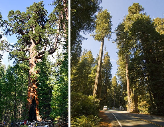
Two Redwoods, two different genera.
On the left is a gnarly old specimen of Sequoiadendron giganteum, the Sierra Redwood. On the right is a typical grove of Sequoia sempervirens, the Coast Redwood.
Redwood habitat?
Coast Redwood:
Coast redwoods occupy a narrow strip of land approximately 750 km (470 mi) in length and 8–75 km (5–47 mi) in width along the Pacific coast of North America... The elevation range is mostly from 30–750 metres (100–2,460 ft) above sea level, occasionally down to 0 and up to 920 m (about 3,000 feet)... The tallest and oldest trees are found in deep valleys and gullies, where year-round streams can flow, and fog drip is regular.
Sierra Redwood:
The giant Sequoia is usually found in a humid climate characterized by dry summers and snowy winters. Most giant Sequoia groves are on granitic-based residual and alluvial soils. The elevation of the giant Sequoia groves generally ranges from 1,400–2,000 m (4,600–6,600 ft) in the north, to 1,700–2,150 metres (5,600–7,050 ft) to the south. Giant sequoias generally occur on the south-facing sides of northern mountains, and on the northern faces of more southerly slopes.
Source: WikiPedia
Where did I see my "Sierra Redwood"? In the San Bernardino Mountains. Both the Sierra Mts and the San Bernardino Mts have granitic-based soils. Both ranges have dry summers and snowy winters. The Sierra Redwoods grow at an elevation of 4000-7000'. My "Sierra Redwood" was growing at around 7500'. All that combined with the superficial resemblance of the bark made me think what I was seeing was a Sierra Redwood . Not so.
The tree was Calocedrus decurrens, California Incense Cedar.
Had I been more familiar with the Incense Cedar and remembered more clearly the few times I had seen a Sierra Redwood, maybe I would not have made such a hasty ID.
There you have it - my longwinded and somewhat tedious explanation of how and why I mis-identified a very fine specimen of the California Incense Cedar.
OK. On with the show.
Cindi and I said our farewells on Tuesday, October the 8th. My original plan was to drive up to Pinnacles National Parkand spend a few days hiking and taking snaps. I had visited there in 2007 and was eager to return. But of course like all the other National Parks, Pinnacles was closed.

Plan B: drive about 120 miles northwest to the tiny town of Mojave and check out Red Rock Canyon State Park which is about 15 miles to the north. The photos and info I found on the web for this park looked hopeful and I was looking forward to visiting some place new.
View larger map
Driving north out of the Big Bear Lake area on SR 18 I passed through Holcomb Valley home to Baldwin Lake Ecological Reserve.
Each summer the lake evaporates, and a rather unique ecosystem emerges that is only found in Baldwin Lake. In terms of soil, when it gets wet it expands, and when it dries it shrinks. For thousands of years the lake has filled with water in the winter and frozen, then thawed and expanded in the spring, and dried up and shrunk in the summer. This process, coupled with the harshness of freezing, has created what is known as the pebble plains - a unique occurrence where tiny pebbles are forced to the surface, thus creating a rare type of soil.
In the springtime a bounty of vibrant colors engulf the landscape with orange, purple and yellow. Those purple-colored delights are known as Parish's rock-cress, and the yellow ones are Douglas' violets.
Also fascinating is the stickleback. This three-spined fish flourishes in the wetter years when the lake doesn't evaporate. The stickleback is also known for its rare breeding practices. Once the females eggs hatch, the male forces the female out of town to raise the youngsters on its own.
Source: © 2011 Big Bear Frontier
~~~~~~~~~~~~~~~~~~~~~~
Benjamin Davis Wilson encountered the lake in 1845, while tracking horse thieves in the San Bernardino Mountains. When Wilson saw that the region was populated by many grizzly bears, he divided his 22 men into hunting partners. The men slaughtered 11 bears for the fur pelts. While returning to Jurupa (Riverside), they slaughtered another 11 bears for the fur. Wilson named the region Big Bear Valley, and the lake he called Lake Big Bear.[1]
In 1884, the Bear Valley Land and Water Company began construction of a dam southwest of the lake. The company's stake holders named the new reservoir Big Bear Lake. They also renamed the alkali lake to Baldwin Lake, after Elias Jackson "Lucky" Baldwin, who came to Big Bear and Holcomb Valley in 1876 when he purchased Gold Mountain Mine (later renamed Baldwin Mine).
Source: WikiPedia
Click on the photos below for a larger image.

As I drove along the north side of the now powder dry Baldwin lake I noticed this twisted old juniper off by itself and stopped for a quick snap.

As I drove north through Holcomb Valley I noticed some interesting cloud formations. Remnants of ChemTrails perhaps? Who knows? I do not.

I left the Holcomb Valley below as I ascended up to Nelson Ridge and the expansive views of Johnson Valley. From this vantage point one can see much of the nearly 27,000 acre (42 sq. mi.) Bighorn Mountain Wilderness and the 7,500' summit of Granite Peak.
Blackhawk Mountain, Cactus Flat, and Lone Valley are names right out of the Old West and they call this place home.

These seemingly endless vistas are what continued to draw me back to the arid west.
After some wonderfully twisty-turny sections of roadway I was now down in the flats of Lucerne Valley.
Some interesting tid-bits courtesy of WikiPedia:
Lucerne Valley's two dry lakes, Lucerne Dry Lake and Rabbit Springs Dry Lake are used for various activities. The Dry Lakes are used frequently in filming projects; notably Rabbit Springs Dry Lake was the scene for the attack sequence in Stagecoach filmed in 1938. Also, actress and singer Selena Gomez shot her music video for A Year Without Rain here.
Chimney Rock, a registered landmark of the State of California, is located on the mountains north of Highway 18 at the Rabbit Springs Road junction as the site of the last battle between settlers and Indians in the Mojave Desert. An official landmark is at Highway 18 next to the welcome sign at the western border of town.
An attempt to construct a golf course and install utilities for residential/commercial zones called "Rancho Lucerne"[5] began grading north of the High School location before embezzlement charges filed against the financier caused the project to shut down in 2001.[6]
Other projects are meeting with mixed reactions from residents and state/county officials, including Solar Power and Wind Turbine plants[7] as well as Water Drilling proposals for the Los Angeles' centric Department of Water and Power, who recently cancelled an attempt to install a 2 mile wide water and power corridor in the Southern half of the town to transport distant resources into Los Angeles.[8]
Source: WikiPedia
I then passed through the towns of Apple Valley and Victorville.
On the west side of Victorville I picked up US 395, a storied road which has its southern terminus just a few miles to the south at Hesperia. As US 395 makes its way north, it spans all of California, Oregon and Washington and after 1300 miles reaches its northern terminus near the Canadian border at Laurier, WA.
In 2007 I explored a section of 395 which passes through Lone Pine, CA - the portal to famous Mt Whitney. That was an interesting trip and one I hope to make again.
I went north on US 395 to SR 58 and then headed west. In just a few miles I passed through the small community of Boron.
Boron is a hinterland community on the western edge of the Mojave Desert. Within a half day's drive one can view the highest and lowest points in the contiguous 48 states of the United States (Mount Whitney and Death Valley), the world's oldest tree (the Bristlecone Pine), and the cities of both Los Angeles and Las Vegas.
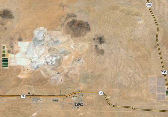
Boron is home to the U.S. Borax Boron Mine, California's largest open-pit mine, which is also the largest borax mine in the world.
Source: WikiPedia

The open pit borax mine at Boron. It is about 2 miles by 4 miles and about 800' deep.
The movie Erin Brockovich(2000), starring Julia Roberts, and various other movies have been filmed in the town, often using citizens as extras.

Now I was getting close to Mojave and the well known Edwards Air force Base which lies to the east and south of that small town.
Upon my arrival to Mojave I checked into the FleaBag Motel where I was to spend the next two nights. I dropped a few things at the room, looked over the map and headed north up to Red Rock Canyon State Park.
I decided to make my first stop the visitors' center at the park. That way I could talk to the staff and also pick up more park info.
When I pulled into the parking lot of the visitors' center there were only two other cars there. The place was very quiet with only a park service vehicle to be heard or seen. I walked up to the front door of the visitors' center and was greeted with a large "CLOSED" sign.
Hmmm... guess the state of California is having its own fiscal problems. It turns out the visitors' center is only open three days a week and this day was not one of them.
I then back tracked to a parking area I had passed earlier, parked and decided to walk the nature trail. By now it was mid-afternoon and getting toasty. So I decided to take a short walk, do some exploring by car to get my bearings and come back the following day and take as much time as needed to hike and snap away to my heart's content.

The formations in the background acted as a good teaser and I was sure I was going to love this place. (Just so you know - it was the sign which was leaning, not me!)

Nice... This is gettin' good!

The rock formations were quite varied and the roadway here seen in the center, passes through some pretty tasty looking stuff.

And, with this shot, my snapping, and indeed this trip came to an abrupt stop.
I was ready to move down the trail and so hit the power button to shut off Canon S100 camera. Nothing happened. I tried it again. Nothing. I looked at the display. My heart sank. It read "Lens Error Camera Will Reset". Here we go again! This had happened just 7 months ago and resulted in a dead camera. And that was indeed the case now. Back in late March I had sent the camera in to be repaired. Luckily it still had two weeks on the warranty. It came back "repaired" about two weeks later. Now, only seven months later, the camera had failed from the very same problem which was supposed to be corrected.
At that point I thought to myself - "This trip is cursed!" Not only were all the national parks, forests and WMAs closed, five days into what was supposed to be a month long trip, I had a dead camera. If I had been able to at that moment I would have boarded a plane and just headed home. And I that is exactly what I felt like doing.
I decided to call Betsy later that day and let her know my current state of mind. Perhaps she could get me calmed down. We shall see.
Not in the best of moods I finished up my walk on the nature trail.
I then headed down the road to check out some other areas. Of course, the road was unpaved. No problem there. But as the surface became looser and looser and the sand in the low spots got deeper and deeper I began to question whether or not the little Focus I was driving was the right vehicle. I was getting pretty paranoid about getting hung up out here. And there was no cell service.
At the next wide spot I turned around and headed back to the highway. Foiled again!
Later on I called Betsy from the hotel to update her about this latest twist in the trip. Betsy's advise - give it a few days and re-evaluate my options. Good idea.
Later that evening I sent out emails to the folks I had planned to visit in Washington and Oregon telling them I was changing my plans and would be cutting my trip short. With no open parks and no camera, the trip was now nearly pointless.
And with that I reoriented my brain as best I could and decided to head up to San Fran the following day.
When I arrived in SF, I got settled into my nest on Potrero Hill and immediately headed out to Land's End for a walk to clear my head. The weather was gorgeous as it usually is in October. I walked and walked and walked and I got back to Potrero Hill around 8:00 pm.
I spent the next several days walking and eating and visiting my old haunts. It was frustrating not to be able to take one picture. "It's always something."
Now I am home.
And that is the wrap-up.
Until next time ...

