Gaza Strip
From Wikipedia, the free encyclopedia.

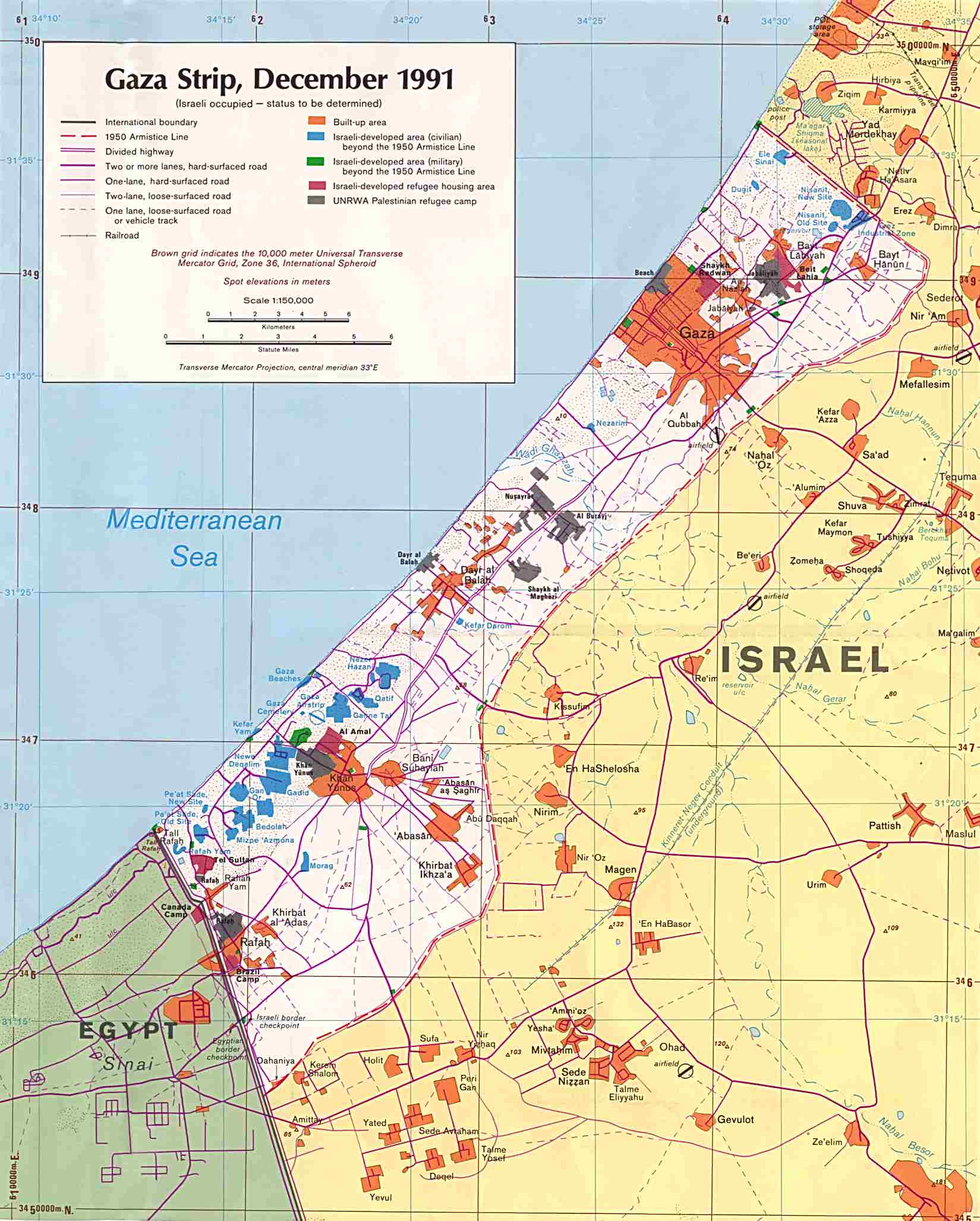
The Gaza Strip is a narrow strip of land in the Middle East not currently recognized internationally as a de jure part of any sovereign country. It takes its name from Gaza, its main city. It is one of the most densely populated territories on earth, with about 1.4 million in an area of 360 km². The Strip is under the jurisdiction of the Palestinian Authority.
Geographically, the Strip forms the westernmost portion of the territories referred to by many as the Palestinian territories in Southwest Asia, having land borders with Egypt on the south-west and Israel on the north and east. On the west, it is bounded by the Mediterranean Sea.
The Strip's borders were originally defined by the armistice lines between Egypt and Israel after the 1948 Arab-Israeli War, which followed the dissolution of the British mandate of Palestine. It was occupied by Egypt (except for four months of Israeli occupation during the Suez Crisis) until it was captured by Israel in the 1967 Six-Day War. In 1993, after the Palestinian-Israeli agreements known as the Oslo Accords, much of the Strip came under limited Palestinian Authority control. In February 2005 the Israeli government voted to implement Prime Minister Ariel Sharon's plan for unilateral disengagement from the Gaza Strip beginning on August 15, 2005. The plan required the dismantling of all Israeli settlements there, and the removal of all Israeli settlers and military bases from the Strip, a process that was completed on September 12, 2005 as the Israeli cabinet formally declared an end to military rule in the Gaza Strip after 38 years of control. Following withdrawal, Israel retains offshore maritime control and control of airspace over the Strip. Israel withdrew from the "Philadelphi Route" that is adjacent to the Strip's border with Egypt after an agreement with the latter to secure its side of the border. The future political status of the Gaza Strip remains undecided, and is claimed as part of any prospective Palestinian state.
Contents |
Demographics
| Languages | Chiefly Arabic |
| Area - Total |
(not ranked) 360 km² |
| Population - Total |
(not ranked) |
| Currency | 1 New Israeli sheqel (NIS) = 100 Agorot |
| Time zone | UTC +2/+3 |
Around 1.37 million Palestinians live in the Gaza Strip. The majority of the Palestinians are direct descendants of refugees who fled or were expelled from Israel during the 1948 Arab-Israeli War. By 1967, the population had grown about six-fold, and the Strip's population has continued to increase since that time. Poverty, unemployment, and poor living conditions are widespread, and their causes have been attributed to the extremely high birth rate, disruptions to the economy due Israeli closure policies since the first intifada, and/or corruptness and inefficiency of the Palestinian Authority. From the 1970s onwards, 25 Israeli settlements were constructed in the Gaza Strip, but these were removed in August 2005. The Palestinian population is growing by around 4% a year. Over 99% residents of the strip are Palestinian Muslim, with a small Palestinian Christian (0.7%) minority.
Demographic numbers for the Gaza Strip are acquired from the Palestine Ministry of Health (2005 estimates)[1]:
- Birth rate: 30.8 births/1,000 population (2005 est.) [2]
- Death rate: 3.2 deaths/1,000 population [3]:
- net migration: 1.54 migrant(s)/1,000 population
- infant mortality: 21.3 deaths/1,000 live births [4]
- fertility: 4.7 children born/woman [5]
- Population growth rate: 2.8% [6]:
Geography
The Gaza Strip is located in the Middle East (at 31°25′ N 34°20′ E). It has an 11km border with Egypt, near the city of Rafah, and a 51km border with Israel. Religious and nationalist Jews claim the entire Gaza Strip as part of Israel while Palestinians claim it as part of a future Palestinian state. The Government of Israel unilaterally withdrew from the Strip and expelled all Israeli residents who resided mainly in Gush Katif along the South Western coast of Gaza. It also has a 40 km coastline on the Mediterranean Sea.
The Gaza Strip has a temperate climate, with mild winters, and dry, hot summers subject to drought. The terrain is flat or rolling, with dunes near the coast. The highest point is Abu 'Awdah (Joz Abu 'Auda), at 105 metres above sea level. Natural resources include arable land (about a third of the strip is irrigated), and recently discovered natural gas. Environmental issues include desertification; salination of fresh water; sewage treatment; water-borne disease; soil degradation; and depletion and contamination of underground water resources. It is considered to be one of the fifteen territories that comprise the so-called "Cradle of Humanity."
It currently holds the oldest known remains of a manmade bonfire and some of the world's oldest dated human skeletons.
Economy
Economic output in the Gaza Strip declined by about one-third between 1992 and 1996. This downturn has been variously attributed to corruption and mismanagement by Yasser Arafat and to Israeli closure policies—the imposition of generalized border closures in response to terror attacks in Israel—which disrupted previously established labor and commodity market relationships between Israel and the Strip. The most serious negative social effect of this downturn was the emergence of high unemployment.
Israel's use of comprehensive closures decreased during the next few years and, in 1998, Israel implemented new policies to reduce the impact of closures and other security procedures on the movement of Palestinian goods and labor. These changes fueled an almost three-year-long economic recovery in the Gaza Strip. Recovery was ended in the last quarter of 2000 with the outbreak of the al-Aqsa Intifada, triggering tight Israeli closures of Palestinian self-rule areas and a severe disruption of trade and labor movements. In 2001, and even more severely in early 2002, internal turmoil and Israeli military measures in Palestinian Authority areas resulted in the destruction of capital plant and administrative structure, widespread business closures, and a sharp drop in GDP. Another major loss has been the decline in income earned by Palestinian workers in Israel, who have been replaced by foreign workers from Romania and Thailand.
According to the CIA World Factbook, GDP in 2001 declined 35% to a per capita income of $625 a year, and 60% of the population is now below the poverty line. Gaza Strip industries are generally small family businesses that produce textiles, soap, olive-wood carvings, and mother-of-pearl souvenirs; the Israelis have established some small-scale modern industries in an industrial center. Electricity is supplied by Israel. The main agricultural products are olives, citrus, vegetables, Halal beef, and dairy products. Primary exports are citrus and cut flowers, while primary imports are food, consumer goods, and construction materials. The main trade partners of the Gaza Strip are Israel, Egypt, and the West Bank.
Health
A study carried out by Johns Hopkins University (USA) and Al-Quds University (in Jerusalem) for CARE International in late 2002 revealed very high levels of dietary deficiency among the Palestinian population. The study found that 17.5% of children aged 6–59 months suffered from chronic malnutrition. 53% of women of reproductive age and 44% of children were found to be anemic. In the aftermath of the Israeli withdrawal of August and September 2005, the healthcare system in Gaza continues to face severe challenges [7].
Transport and communication

The Gaza strip has a single standard gauge railway line running the entire length of the strip from north to south along its center, however, it is abandoned and in disrepair, and little trackage remains. The line formerly connected to the Egyptian railway system to the south as well as the Israeli system to the north. It has a small, poorly developed road network. Its one port was never completed after the outbreak of the Al-Aqsa Intifada. Its airport, the Gaza International Airport, opened on 24 November 1998 as part of agreements stipulated in the Oslo II Accord and the 23 October 1998 Wye River Memorandum. The airport was closed in October 2000 by Israeli orders, and its runway was destroyed by the Israel Defense Forces in December 2001. It has since been renamed Yaser Arafat International Airport.
The Gaza strip has rudimentary landline telephone service provided by an open-wire system as well as extensive mobile telephone services provided by PalTel (Jawwal) or Israeli providers such as Cellcom. Gaza is serviced by four internet service providers that now compete for ADSL and dial-up customers. Most Gaza households have a radio and a TV (70%+), and roughly 20% have a personal computer. People living in Gaza enjoy access to satellite television (Al-Jazeera, Lebanese and Egyptian entertainment programs, etc.), local private channels, and broadcast TV from the Palestinian Broadcasting Corporation, the Israel Broadcasting Authority and the Second Israeli Broadcasting Authority.
See also
- Gaza
- Israeli-Palestinian conflict
- Israel's unilateral disengagement plan
- Jabalia (Refugee Camp and village)
- Occupation of the Gaza Strip by Egypt
- Occupation of the West Bank and East Jerusalem by Jordan
- Palestine
- Political status of the West Bank and Gaza Strip
- Smuggling tunnels
- West Bank
External links
- Legal Status of West Bank, Gaza and East Jerusalem
- United Nations - Question of Palestine
- Gaza Strip from the CIA World Factbook
- Nutritional Assessment of the West Bank and Gaza Strip
- 1991 Map of the Gaza Strip from the University of Texas
- General Moufaz about current Israeli plans for Philadelphi corridor
- Gaza women join Hamas fighters by Khaled Abu Toameh, published in the Jerusalem Post August 21, 2005.
- Gaza Strip at Google Maps
- Palestine Ministry of Health

