

Welcome to 1977 where $12 hotel rooms and .60/gal gas are the norm. This account of my dads trip was originally transcribed from cassette tapes he made while on the road. The conversational nature of the journal at times made me feel like I was sitting in the car seat next to him.
At times he wandered a bit and seemed to be talking only to keep himself company. I am sure not having to take written notes encouraged him to be a little bit more talkative than normal. He even went on a little trip down memory lane and talks about his solo trip to the 1933 Worlds Fair when he was just a boy of 13 years of age.
The journal is not complete without the slides he also took on this trip and I hope to add those at a later date.
-Mike Breiding
"Number 2 son"
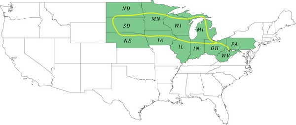
Central States North Trip: June 2nd to June 15th, 1977
Kirtlands Warbler Sojourn- Bird List: 140 species
- Mileage: 4000
It's June 2, 1977, and I am on I-79 in Pennsylvania crossing the West Virginia border on my way up into Ohio finally and into Michigan to Mio, the center of the Kirtland's Warbler area in the United States. I left Morgantown about 8:20 a.m. EST with the speedometer reading 29,110. The idea of the tape recorder is first to keep a record of the birds and to make some comments to be used as notes or as a diary or log of the trip. The only bird I've seen so far in 10 miles time is a couple of scattered small groups of starlings; add Grackle to the list.
It's a bright, beautiful, clear morning. Hardly any clouds at all. Just a trace. It's cool. I don't know what the overnight temperature was but I imagine somewhere down in the 60's so everything is clear and light and it looks like it has prospects of getting much warmer before the day is out.
Everything looks so green and beautiful and fresh this morning. Maybe it is just because I am starting out on this trip, but between Morgantown and Mt. Morris the slope covered with crown vetch was a solid mass of pink and also beyond Mt. Morris and near the Kirby Girard's Fort exit, I saw a stand of moth mullein. The blossoms looked like they were all whitish or cream colored.
Add Red-winged Blackbird to the list near Waynesburg exit. A plant to add to the list in Pennsylvania, between Rough Creek and Marianna is poison hemlock, and it's the one I believe with the lacy or leaves like Queen Anne's Lace leaves. I think the blossoming period and the development of that plant is just about on schedule.
Starting to pick up a few clouds now. They're scattered, fairly good size. There's a Penstemon in blossom approaching Washington, Pennsylvania. It looks like it's that gray beard tongue. I'm ready to approach the turn-off, 179 at Washington, Pennsylvania, and it has taken me exactly one hour.
It's now 9:20. Most of this is going to be somewhat new territory for me. It has been so long since I've been over some of it and once I get beyond Pittsburgh and up into Pennsylvania and head over into Ohio, it has been so many years since I've done any field work or observations, all of this country I'm starting out on from Washington will seem like practically new. I need to get reacquainted with it again. Cloud cover is beginning to build up. In fact it looks kind of dark to the north and west. I may run into some rain. But it also feels like it's getting colder, I should say cooler. There's a nice big stand of I guess wild parsnip, but coarse, yellowish looking Umbelliferae and also in the right places there are pretty well scattered and heavy stands of that poison hemlock.
I'm at the Houston exit, 179, I think it's exit 159. Add cowbird. That must have been route 159, not exit 159 back there. I just passed exit 10, Cannonsburg. I'm probably 16-17 miles out of Pittsburgh, and I can begin to smell it. I don't know whether it's right out of Pittsburgh, but I'm getting an odor.
Well, there goes the first crow at Carnegie. I hit exit 279 parkway north at approximately 9:45. I'm 2 hours out of Morgantown, have come 85 miles and just hit I-76 the toll road. Also I stopped and got gas back there. I just hit the first 100 miles. It is 10:45 so I am averaging about 40 miles an hour—stops and everything.
Add Kestrel to the list.

I just left the toll gate of Pennsylvania turnpike. The toll was 50 cents. Now to get on up into I-80 Well what do you know, there's an English sparrow. It's 11:45 and running into a fine misty sprinkle. I stopped at the Portage service plaza, Howard Johnson's, at noon and it looks like we're going to get a good steady rain here. This weather has turned real messy. Rain and low ground fog.
Another bird for the list, a pigeon, rock dove. It's about 1:40. I am going to stop off to eat. I brought a lunch with me. The weather is horrible. I'm at the Great Lakes service area. I'm only 112 miles from Toledo. I'm making a lot better time than I thought. I guess I could have really made this trip in one day if I really wanted to push myself, get tired out.
I'm 100 miles from Toledo at 1:20, approximately. Here in this general vicinity of Cleveland, there is a solid string of traffic and most of them are trucks. Traffic was really heavy. Backed up for a while then it seemed to have eased off and now another wave is coming. I'm keeping a fairly moderate speed here, just around 50-55, just cruising right along and making real good time. And would you believe I got a Robin.
I made another comfort stop at a rest plaza about 80 miles out, about 10 after 2, maybe 5 after. So I guess I'll ease on but I think I'll make one more stop and check on where I find my lodging for tonight. I've come 218 miles so it looks like my trip is going to be about 300. Also there seems to have been a cold front move in and the rain has let up. I don't know whether it is going to clear or not. There is a road marker, Toledo 79 miles. I don't think I have to go all the way in there. I'm about a couple of hours out, and that foggy condition has lifted a good bit.
It's still a heavy overcast, but not that low pea soup. Also when I stopped back there I heard a meadowlark and there just went a goldfinch across the road right at the Erie county line.
Add to the list Mourning dove. Add barn swallow. Add a turkey vulture. Saw two today widely scattered area. I've been coming through miles and miles of rich, lush farmland. Must be that limestone that is in here. Is it that Berea, I think maybe it is. There are lots of tourists on the road, I can tell from the way they are all packed and loaded and from all the different licenses. All over. I'm kind of surprised on account of school not being out but I guess I haven't seen too many youngsters in those cars.
Add kingfisher, Stony Ridge Road.

I'm at Day's Inn, approximately 4:15 p.m., speedometer 393, and therefore it was 283 miles, I guess. It's overcast and hazy as I wind up but it's pleasant, it's calm and quiet here.
This is Friday, June 3. I left Day's Inn, Perrysburg about 8:30, speedometer 29,393. I'm heading on up on 475, the general direction of Ann Arbor. It's a nice cool, pleasant morning, able to see your breath when I came out of the motel room. But the sun is shining, a few scattered high cirrus clouds and Ann Arbor is about 55-56 miles away. So ought to be up there about 10 o'clock and then proceed northward on into Flint and then from there I will have to see where I want to make some stops and start to do some looking at birds and plants.
I stopped at the temporary information center here at this rest stop, and nobody on duty apparently. Just a trailer with a rack with some folders and stuff. Picked up the red-eyed vireo and the yellow-throated vireo in the wooded area behind this rest stop. I've been here before.
There goes a Red-headed Woodpecker right through the woods. Lawrence Cavendish and I stopped here one time when we went to Michigan State University for a summer workshop. I remember we went back into the woods and got ate up with mosquitoes.
It's now approximately 9:15. I made about a 15 minute stop here. The sun is up and bright, full blast now. Some of that early morning haze has been burnt off. I think it probably is going to get pretty hot in Michigan today. I see down in the sections where I am now, a northern oriole just flew across the highway. Sure is nice to get off of those big interstates. A little traffic by comparison on this road to what it was yesterday. Traffic moves though, but boy not those long lines not as many trucks.
It is approximately 9:50 and I am now passing Ann Arbor. I saw a swallow. I don't know whether it was the way the sun was hitting it or not but it looked like it might have been a tree swallow. This area on US 23 northeast of Ann Arbor is all new territory for me now. So there looks like a grebe out there on that pond and a duck. I am going to have to do some stopping. It's about 10 o'clock and I have traveled 60 miles. My travel speed is holding around 40 miles to the hour with my stops, looking at a bird now and then or something.
It is 10:45 and I am stopping off at a rest area. I don't know which one it is or exactly the location. I know I am about 12 or so miles south of Flint.
Add Wood Thrush, Song Sparrow and Cat Bird at the rest stop. The traffic has started to pick up in here pretty good and this road is full of filled in pot holes which is making for real bumpy riding. It is now a couple of minutes after 11 a.m. and my speedometer is ready to turn to 493 miles which is 100 miles this morning in about 2-1/2 hours or a little more.
The speedometer or odometer has just turned 510 miles which means I am 400 miles exactly from 38 Edgehill Street, Morgantown. I don't know exactly where I am but I am on US75, 10, and 23, 6-lane highway, in other words, 3 lanes on either side. And these cars are really moving up here through here. At mile post 129, which I guess means I've been in Michigan for 129 miles. The closest town in Montrose and Cleo exit 57. Getting up into the white birch country now, just saw some along the road. Just gone over a draw bridge over the Saganaw River [Saginaw River]. Haven't been over a draw bridge for some little time. I think Florida probably the last. Some kind of a gull just flying overhead. Didn't get a good look at it. Had black wing tips, didn't look like a real big gull.
I'm cutting off at the Interstate and getting on State R-13. Get off this race track and on a wilder road. I'm going to try to cut up into another town called Pinconning, I think, state forest up in there. I'm going to take this road for a while and see what happens. Might be some places to stop off and look for some different birds, but it looks like it is pretty well developed. Looks like it's just more or less like the old road that went up through here. It's paralleling the interstates.
According to the map and by the looks of the horizon on my right going up through here I guess the lake is out there.
The Bobolink, Dolichonyx oryzivorus, is a small New World blackbird and the only member of genus Dolichonyx.
Adults are 16-18 cm long with short finch-like bills. Adult males are mostly black, although they do display creamy napes, and white scapulars, lower backs and rumps. Adult females are mostly light brown, although their coloring includes black streaks on the back and flanks, and dark stripes on the head; their wings and tails are darker.
Their breeding habitats are open grassy fields, especially hay fields, across North America. In high-quality habitats, males are often polygynous. Females lays 5 to 6 eggs in a cup-shaped nest, which is always situated on the ground and is usually well-hidden in dense vegetation. Both parents feed the young.
Source: WikiPedia

There goes my first Bobolink in area, and a yellow warbler. And I stopped here along this drainage ditch and open fields and I squeaked in a Marsh hawk. Maybe the mike will pick up that Yellow warbler singing. Red-winged Blackbird calling in the background. High pitched single note. I guess it's a Yellow warbler, sounds like it but I can't see it. It's just flitting along these willows through here. The name of this game area that I'm on is Nayanquing Point, and I guess somewhere I hear a Swamp sparrow. It looks like a good place for one to be. It looks like this is some kind of a marsh management area. Maybe the state has some and it looks like they might have some of the private lands leased.
I've got several birds to add to the list. Spotted sandpiper. Blue-winged teal. Coot, Willow or Alder flycatcher, Yellowthroat, Ring-necked pheasant. Shoveller, and Virginia rail, and Ring-billed gull and Chipping sparrow. I've been on US23 and now I am going to cut off and hit Michigan state route 65 north.
Also add Chimney swift to the list.
Those mare's tails, as in horse, mare's tail clouds have been building up all day and ordinarily these are an indicator of rain within the next 24 to 36 hours. We'll see whether that works or not.
I'm cutting off at Michigan route 65 to 55 over to Tawas City. One thing I've noticed, they don't have their roadside facilities parks marked too well. They give you a warning with a sign that you are coming into it but you don't know whether it is on the left or right or how to approach it. Also I keep seeing markings of forests, national and state forests, on the map, and get around in the area and pass right by; no signs, especially the state forests. I saw one sign, national forest campgrounds but didn't say how far or anything else. I guess if you live up here you are supposed to know.
Here I am at Tawas City and it is right along the lake. Run right smack into it. Lots of white caps out there. I am proceeding north. I don't know how far. Want to see how things to here. And I just saw a Black tern. Haven't seen one of those for a long,long time.
It's a pretty good sized little town layed out nice and clean. I guess that breeze from the lake and the spray and everything keeps it clean. I'm headed down to the public beach and landing area. See how this goes down in here. Might be some water birds. And I just heard a Parula warbler, and I just heard a Redstart. Some birds to add to the list: Flicker, Purple martin, House wren. Blue jay, Bonaparte gu11, common tern, and semi-pal mated sandpiper.
I met a ranger at Tawas Park, and he said his name was Ron MacMurray. Said he had been to Oglebay Park and went to school at Michigan State with somebody who had worked at Oglebay Park years ago.
Add to list - Tree swallow, following right up along the lake. Some-where back on those side roads I passed the 500 mile mark from Morgantown. I'm back on US23 heading north to Oscoda. From Macado, I was on county road S30 and came out to a junction and turned right and came over to SR73W which eventually should lead me to Mio, about 30 miles, and my destination. It's now about 4:50 and I am going through Huron national forest, Reid Lake area.
And there goes a Great blue heron across the road and I should add Chestnut-sided warbler. Purple finch and Vesper sparrow. That Reid Lake is Reid; that sign back there of the national forest is really the first formal sign that I saw on any of these forest areas. I guess it must be the state forests that don't mark their areas too well. In the last hour I have really come through some back country—farmlands and now wooded lands of course going through this national forest area. Very little sign of human habitation. I'm at a stop here and I am going to turn right over to Curran. Looks like a lot of interesting bird country through here. It's 5 p.m. and if all goes well I should be over at Mio I suppose between 5:30 and 6 o'clock. Just passed through the little village of Curran. This area I am going through almost reminds me of some of the places back home. Some of the lower mountainous areas. Vast areas; looks like mostly timber and wildlife and recreation. But I suppose it is all just waiting for development. This section I am going through right now reminds me a good bit of some of the areas of Upshur county.
If I didn't add Indigo bunting to the list on the tape, do so. I got one back there at Oscoda, I guess. Now coming into the village or town of Fairview. Somewhere there should bee turnoff to Mio. This sign coming out of Fairview says Mio is 9 miles. We'll see. I am approaching the Pine Acres Travel Park now and this is where Dick Winters should be and it is just about 5:45. Beautiful evening.
Add to the bird list Rose-breasted Grossbeak and Broad-winged hawk.
I think I have found Dick Winters' trailer and car but he doesn't seem to be around.
Add Myrtle warbler and Cedar waxwing. Add to the bird list, Nighthawk.
It's Saturday morning, June 4, 1977, and it's gray, bleak, heavy over-cast, and looks like it is going to rain, and I guess those cirrus clouds were right when I saw them early yesterday afternoon, so I don't know what my plans are going to be.
I finally wound up in a room at the lodge here at the Pine Acres. Dick Winters did not get back in till late. He went out on a mission of mercy to help Lawrence Watkinshaw out of some car trouble about 30 miles north of here so I didn't see him till late that night after he got back in and Dick's wife Mary is along with him, so our plans are kind of scattered. Didn't have a chance to make much opportunity but in the meantime I got acquainted with a young man by the name of Jim Bull who is leading the trips for the Forest Service.
The tours to go out and see the Kirtland's warbler, so I guess my plan is to go out and make that run this morning and then see what happens from there. Had I seen Dick earlier last night I'm sure the whole set of plans would have been changed because I think he was going back up again this morning to meet Dr. Walkinshaw who is also working on the Kirtland's warbler problem.

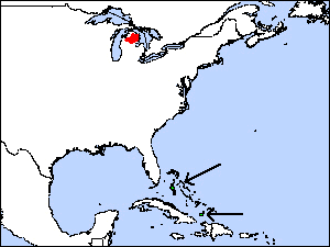
Range & population Dendroica kirtlandii breeds in north and central Michigan, with small numbers (and occasional breeding) in Michigan's Upper Peninsula and Wisconsin, USA. Breeding was also recorded in Canada in 2007 for the first time since 1945.
Breeding habitat has declined by 33% since the 1960s, but is more extensive than the 18 km2 occupied in 1994. It has a very small winter range in the Bahamas and the Turks and Caicos Islands (to UK), either concentrated in the northern islands or spread throughout the Bahama Archipelago.
There were major declines in c.1900-1920 and 1961-1971, with the population just 167 singing males in 1974 and 19872. Numbers have recovered to 1,478 singing males in Michigan in 2006, the highest since surveys began in 1951.Source: BirdLife International.
This is a test to see how far away my voice will pick up from the recorder. This is another test. I'm about 6 feet away. I am trying to test this thing out to see what I can record as far as the car... It looks like picture taking is going to be out of the question today. At 8:30 the windshield has been hit with rain and it's heavy cloud cover. I don't know if it can break up or not but it looks like it might for a while. I think there is supposed to be showers predicted for today. It would be kind of ironic all of the bright sunny weather that we have had for the last week or 10 days and then come up here and be socked in with rain most of the time but that is the breaks of the game.
This is another test to see how this recorder is picking up in the car.
We had a movie and orientation of Kirtland's warbler at the ranger station and now at about 9:25 we are going out through the town of Mio and heading out to the warbler area. We're heading out of Mio on Michigan State route 33. I think the turnoff area is about 4 miles from town and then about 4 miles somewhere out in the forest; in other words about an 8 mile trip. We are turning off down here to the left. I will see what road this is. It's the Mousky road and going to the Mack Lake campground. We are on Oscoda county road 489 but now leaving it and coming into the Kirtland's warbler management area. There is a sign. The sun has burnt that heavy overcast layer of clouds and there is a good bit of sunlight now and t is hot and humid. We're probably going to get a storm. The tour ended about 11:30 and the main group went back into Mio and I retraced my steps and came over to the Huron national forest campgrounds and eating lunch and will go back and rejoin this afternoon's party.
This campground is located on Mack Lake. It is kind of interesting. The surroundings here are just like being around Terra Alta, Preston county, West Virginia. And if it sounds like I am eating as I record this, I am.
Tanager in the background. Maybe like Terra Alta this place has a lot of birds, good variety and also numbers. As I eat my lunch here there is a little ground squirrel digging a hole not too far from this picnic table and it is one that is called a 13-lined spermophile. They are very common over flat, dry, sandy country.
We made stops at 3 different stations. The first two were unsuccessful. The birds did not appear but they were singing. I think it was mainly on account of the large group this morning--I guess around 40 people which is unusual unless it is an organized school group or something like that. But being Saturday morning why a big group of people here even a group of men from Philadelphia drove all night to get here. On the third stop we heard the Kirtland singing and I got away from the group and I was able spot it and point it out to the rest of them. It was a good distance away but Jim Bull, the tour leader, had a telescope and we got zeroed in on it and was able to get a real good look at it through the scope.
It's 12:45 and it is beginning to cloud up again and get breezy so maybe that rain is going to move in. It might have some effect on this afternoon's trip. We went through about a foot of dust on the way in so maybe this afternoon coming out we will be in about two feet of mud just like East Africa.
I'm back at Pine Acres and that rain never developed, hear a lot of thunder south of us. We had constant breezes and heavy overcast but the rain never came. Also there was not an afternoon tour, there wasn't any-body showed up so I met that bunch of fellows from Philadelphia and one of them was from New Hampshire, so we just scouted some of the roads of the forest looking for the Clay-colored sparrow.

I spent the evening chatting with Dick and Mary Winters and making plans for tomorrow.
Sunday, June 5, 1977. Dick Winters and I went up into the Lovells and Shupac Lake area on the Kirtland's warbler study area operated by Dr. Lawrence Walkinshaw and also in the area of the warbler tour operated out of Greyling [Grayling] . There were quite a number of the birds in this area and I saw a number of different birds that I had not seen before or had not heard the song, and I'll give those in a list. All in all we had a real big day; the weather was very good, and as a sidelight addition we had lunch at the Gate's Lodge located at Stephan Bridge, R-2, Greyling, Michigan, 49738. They have a lot of fishing and canoeing there right along the [Au Sable] river.
If I have included everything on the bird list that I am writing down as a separate record, I have 86 species listed now, so things are moving right along.
We saw one deer today and one porcupine along the road of which I got a picture and we saw many of the 13-lined ground squirrels. I am getting a late start this morning. It's about 8:45 but I had a lot of visiting to do around the campground, talked to Dick Winters, people who owned the campgrounds, some of the other people here. It rained during the night, poured down a couple of times. Woke me up. Got a cold driving rain about 8 o'clock, and now it is down to just a cold drizzle. Seems to be getting colder, so maybe there's a cold front moving in and I don't know how soon it will clear but I am going to move on northward now.
I hit Greyling about 9:25 and an outdoor thermometer said the temperature is 49º. It's 10:15 and I have come 70 miles and there is still a sprinkle of water on the windshield but there's a touch of blue up ahead, I think in the direction I am going, so maybe things are going to break up and clear off for me here a little bit this afternoon. The traffic has been relatively light and of course up in this area on a Monday morning that's what you'd expect. There's a few birds starting to move back and forth across the road. The road is a little drier than what I have come through so maybe this rain pattern is going to break up or at least maybe intermittent showers that will give me a chance to get out and do some work.
It's now 10:45, I've been on the road 2 hours, speedometer reading is 855 which is 4 miles short of 100 miles, so I am averaging pretty close to 50 mph without any stops, but I think I'm going to have to make one pretty soon. The skies have opened up in front of me, a beautiful blue, big white clouds, not those heavy dark ones that I have been coming through for the last couple of hours, so maybe the rain has ended or I have run out of it. Will hope so.
I don't know what has caused that distortion [on the tape recorder], maybe because a couple of big trucks ran by but anyhow I stopped off at the travel information center at Mackinaw City and didn't get much information about what I am interested in—-needs to be more information developed in the areas of plant and bird and animal life for these tourist information centers. I am crossing the bridge now and it's 11:20. This bridge is 2-1/2 miles long. The lilacs are just in blossom up here. They must be a month or so behind us. There's the big blue sky out yonder now. It's clear, sunny, cool, and breezy.
I'm on Michigan R-123 heading north up into Strongs and along these drainage ditches it looks like there is spruce, and white cedar. Also the peonies are just in blossom up here. On the way to Strongs is trout lake so maybe I'll hit up there around time to get a snack—-that is out of the back end of the car—-stop, maybe and look for a few birds.
This is rural Michigan up in here—all flat, mostly grass, woodlands. Trout Lake is not a lake, just a village I've passed through. There are some lakes around it but no access so I am going to keep going northward. I guess a good stretch of this road that I am going up through is on the Chippewa National Forest. Not many breaks and places that I see that I can stop and look for birds. At least I don't see them soon enough to anticipate them. I have finally cut off here through the national forest over to Strongs, taking off of 123.

Just heard a Least flycatcher which is new for the list and there is some kind of big black bird flying in the air, and it's a Raven. Add to the bird list Winter wren.
I guess I must be running through two national forests in here. Right now I am on the Hiawatha. I got gasoline at Strongs. I am heading westward now on 28. Gasoline back there, lead-free, Amoco, was 72 cents per gallon. There seems to be a good many Myrtle warblers up in this country. I hear them singing as I move along. This road, Michigan R-28, good straight road, it's only 2 lanes but you move right along on it.
Add to the bird list Broad-winged hawk.
I've been on a wild goose chase here for about the last hour and a half. Trying to find one of the side entrances to the Seney National Wildlife Refuge, and of course the pun is that the flying wild goose is the emblem or symbol of the national wildlife refuge system. I had to retrace back into Seney and heading down towards the refuge there so I don't know what I am going to run into. The headquarters is supposed to be down in here some-where so maybe I will find out something. The road I was trying to find marked on the map at Creyton[Creighton] after I located it running back and forth I found out that a bridge was out on the road about 4 miles from the entrance so that's why I had to retrace back to Seney.
Add to the list Broad-winged hawk and Wilson's snipe and Lesser Scaup, and also add to the bird list Olive-sided flycatcher.
I left the Seney refuge about 5:20 headed for Manistique. A place to live tonight. I am at room 3, Blue Spruce Motel with a beautiful view of the lake and my room with one double bed is $8.32 with tax. I doubt if I'll equal or beat that rate, but who knows out through these tourist traps what the rates might be.
This is Tuesday, June 7, and I woke up this morning to an experience I haven't had for a long time, and that's being awakened by the songs of the White-Throated sparrows.
[At some point, perhaps when he was in his late 70's, my dad started making it a habit of coming out to our home outside of Morgantown at least once a year to hear the White-Throated sparrows. He did this up until the year of his death at 89 years of age.]
This used to happen in migration when I worked and lived back in Oglebay Park. It's a beautiful, clear, cool morning. Down to 40º overnight. So it's crisp here this morning, but it looks like it is going to get up into real pleasant temperatures this afternoon. Down in this area along the lake I have run out of the northern conifers. Pines down in here and some various broad-leaf trees, whatever makes up this central states hardwoods.
If I am going to get some of those more northern-type birds, I guess I am going to have to head north and I think I will. I think I'll go down to Rapid River and head up to Marquette and hit 28 and go on out towards Duluth.
Add to the bird list - Brown creeper. Black-throated green warbler. Another new mammal to add to the list. Crazy, the varying hare or snowshoe rabbit took out on the highway and just ran all around. I tried to miss it and honked the horn and the thing ran back towards to car and just sat there. Something might be after him. It, that is. To the bird list, add mourning warbler. I got it at Perch River [Lake?] on Ottawa national forest in Michigan. Arbitrarily that is the 100th bird for the trip. The nearest town where I got that Mourning Warbler is Sidnaw.
It's about 1:45, this is June 7, and it's beginning to rain. Looks like there's big heavy clouds everywhere in all directions, and it's a chilly rain. After about 15 minutes the rain quit, or the shower is over or is waiting for the next one to pass over.
I hit the Wisconsin, Michigan state line about 2:45. I'm beginning to run into some of the Wisconsin grasslands up here now. A lot of this area is a lot more open than back where I came through in Michigan. Beautiful rolling country and it is green, green, green.
Add to bird list Great blue heron.
The state of Wisconsin must not believe in catering too much to the tourists. I've been in the state a few miles now and no sign of a roadside park, tourist information, roadside rest, anything like that. Maybe there will be out here a ways but I think if there were going to be any it would be in here by now. Finally hit a roadside park. I must be 50 miles into Wisconsin.
Well this was an interesting stop. There's a Veery singing in there, full blast.
[Like all birders, my dad loved the song of the Veery. He introduced me to the song at the Mountain Nature Camp of Oglebay Institute where, as a youth he was a camper, then staff and then eventually director.]

Male Veery and map of breeding range.

Well it looks like all the rain clouds have cleared away. Bright, sunny, and clear again and getting much warmer. There's another roadside park coming up. Two of them almost within 5 or 6 miles of each other.
I arrived at the Lakeview Motel at Superior, Wisconsin, room 11 and my room is $12.00 but low and behold the tax is 7 per cent. After supper I went out to the lake on Wisconsin Point and ran into a heavy lightning and thunder storm and of all things I got hung up in the sand and wound up by finally getting somebody to pull me out. I was late getting back in and so had to make plans and get recharged for tomorrow.
This is Wednesday, June 8, and I am on my way out of Superior. There were heavy rains in early morning, showers; it's gray and overcast now. My watch has 9:15 but it's only actually 8:15 here. They're on Central Standard Time, now Central Daylight Savings Time. I'm actually headed back east. I am going back here and pick up a road, head south, down into one of the state of Wisconsin department of natural resources game areas and then proceed westward from there, and I am going to bypass Duluth and get away from that big city complex and go the round-about way. I don't know exactly what I will run into in the way of roads and country and weather, but we'll see.
Also add Pilleated woodpecker.
What I have done here is retrace my path to east of Superior and am now on US53 down to a town called Spooner. It's about 9:15 there time here. Going to change my plans. I checked my tires and looks like I've got some uneven wear on one of them. Probably a wheel out of line so am going to change plans to go down here to a town by name of Minong and see if I can have it checked out.
The sun is now blazing hot and I bet it is going to be that way for a while today. Probably the heat will build up and have more showers like they have been having around here.
I had the car checked out. It is not the wheel alignment. Had a bad right front spring. So I've got another problem I'm going to have to get worked out. While I was waiting to get that car into the garage, I ran out to that bird sanctuary for the sharp-tailed grouse. Nothing particular happened. I did see the Brewer's blackbird. Add that to the list. Add to the bird list Green heron.
Also grey squirrel crossing the road. That was near Siren, Wisconsin. I came down to R-70W and now crossing over, should hit the Minnesota border sometime within the next 45 minutes. The area I am going through now is part of the cheese belt. It's a beautiful afternoon; big clouds, blue sky, and somewhat of a cool breeze, but the sun is warm.
I am on 135 heading north and will try to find R-18 that leads over to Brainerd. I cut off of 135 and got on to Minnesota R18 heading over to Brainerd. This country I've been coming through mile after mile is just one series of lakes of all sizes, some pretty good sized, and one resort after another, right with the lakes. It's easy to see why Minnesota is in the tourist business. They've got the water.
I'm on R-210 heading West. I don't know where my destination will be yet tonight. My destination is Detroit Lakes, Minnesota, at the Oak Manner Motel. I arrived about 7 o'clock ET, 6 o'clock their time here. I have pulled room no. 11 and the rate $12.00 a single. This country is really something without any hills. It's daylight almost till practically 10 o'clock. At 5 minutes to 10 their time here the Robins were still singing and so were the western meadowlarks. It is kind of interesting, today I woke up with the song of the Purple finch, and when I came out of my motel room and tonight when I took a stroll up and down through the business section right through here why it was the Western meadowlark singing all along. Well I stopped at the Lakes Ford garage. They checked over the alignment, suspension, said everything is all right. Still can't figure out what happened to that tire getting all chewed up.
It's bright, and sunny, and clear here this morning, Thursday, June 9, and I am going to try to work my way over into Rothsay where there is supposed to be a Prairie chicken wildlife management area, so will have to work my way over through there. Probably go on out past through Fargo, North Dakota, and then from there I don't know. See where we are. Some specifics on reaching that Rothsay wildlife management area. Out of Detroit Lake I took 59 and 34 which is south and west and at Pelican Rapids on 108 and from there I am to proceed on R21 I guess county road and then to 24 which should take me on into Rothsay or near to it. Add to bird list Redhead, that is the duck.
I am at Rothsay now and that wind is blowing in here like it is going to snow. And speaking of weather, I think a lot of these places in Michigan and Minnesota had freezing or near freezing temperatures. I guess there have been a lot of low records, new records or equal records.

I can't seem to find out too much about this wildlife management area for the Prairie chicken but one of the key persons is Mrs. Clifford Ousi who is about 3 and 8/10 miles west of Rothsay on county road 26. Wilken county. So things are kind of jammed up in there for not getting any information. Rothsay is supposed to be the Prairie chicken capitol of Minnesota. Not only Prairie chickens in here I guess but there sure are a lot of Mourning doves. Another bird to add is Yellow-headed blackbird. Another bird - Marbled godwit. I took a picture of this with telephoto lens at very close range. I hope I zeroed in okay. I was lucky to get that bird. It was split-second timing. Just as I fired my two shots at it, two cars came along and scared it right off the middle of the road where the bird was out feeding. Crazy. That Godwit is kind of a grotesque bird, long-legged, body is little bit bigger than a pigeon I guess more or less, and a great big long upturned bill. Well I finally went out and hit county road 9 and cut down to 52 which leads back into Rothsay. So I will have made the circle around more or less the whole area and suppose this management area with all of these farms in here, these people have agreed more or less to look after the bird or what. This whole area in here is just a sea of green and wheat and grass, I don't know what crops they've got in here. It looks mostly like a lot of wheat and a few patches of trees along the small streams and a lot of drainage ditches. The drainage ditches are down so I can't see what is in them as I drive along. Probably have to spot-check these on foot sometime.
It's about 3:40 p.m. in this country now and I stopped out and I inquired around and found some people who had an interest in this bird. It's a Ralph and Roberta Ouse a young to middle aged couple. They were very gracious. Showed me where the management area is. That management area is some of areas that have been bought up by the state as part of the nesting grounds for the birds. Also that big 13-foot high prairie chicken or 15' or however high out there at the junction of the Interstate, was engineered by a man by the name of Art Fosse, and after I had spent some time out on the management area I stopped back in at Rothsay and I found him and talked to him. So all in all it was an interesting afternoon out there roaming that prairie country for several hours by myself although I didn't flush any of the birds, I felt very close to them. And of course there is only one way to be sure of seeing the bird, is to spend a lot of time out there or be here about the middle of April when the males are out on the dancing grounds. It must be quite a sight. I've seen pictures of it and done some reading on it before, but it's too bad that I am here so close and yet so vary far from reaching the mission to see this bird. But I am not through yet. I will go down into South Dakota. There is supposed to be birds down in there.

I am going to head out of there now and go on into Fargo, North Dakota, and beyond probably into Jamestown which is about 100 miles and should take me 2 to 3 hours to get in there depending on how many stops I make and try to find a place to get holed up for the night and work North Dakota tomorrow and head on down into South Dakota. See how things go here.
If I ever wanted to bring a group out here which could be a pipe dream, there's the I-94 Motel here. It's only about 7 or 8 miles out to the dancing grounds. I'm going here on I-94 and over towards Barnsville. That big old Prairie chicken is starring me right in the face as I leave town to hit for the Interstate. Mr.Fosse, I talked to, he looks like he might be around 60-65, said when he was a boy there were thousands of Prairie chickens in this area. By comparison there's very few now. Fargo is about 60 miles from here, so if I don't make any stops I should get in there about 5:15-5:30.
Here's a sign that says Fargo 38 so that means I should make it very easily within an hour. I am just going by the calculations on my map. That's the way the map distances were shown by estimate. It's cloudy and overcast, bluish-gray all over, just a little bit of light coming up from under the meat of the clouds. Had a few sprinkles of rain a couple of times this afternoon. No more than about like 50 drops. Not enough to even wet things down. They need rain in this country I can see by some of the areas out in the fields that I worked they are down and dry there mucky instead of having water in them. So I will go into Fargo I guess, get some gas and be ready to move on.
I just passed the exit that says Fargo, so I guess I am now in North Dakota. Looks like a big thriving community. Apartment buildings, as far as you can see. This place is really spreading out. New big homes, boy they are realty expanding. Well I finally ran into the rain, and it looks like it must be a shower but it is kind of pelting it down. I have run out of that shower, lasted about 15 minutes. I don't know if there is another one up here ahead or not. It looks like there is rain up there but don't know if it's the same direction I'm going.
I've reached the continental divide with the amazing elevation of 1490 feet but it is just kind of a gentle soft rolling plains. I guess instead of hilts and hot tows out here they've got humps and dips. Well the clouds are gone, the sun is blazing again, looks like it is going to be a warm pleasant evening if the wind dies down.
A big rabbit dead along the road. Probably a Jackrabbit. I'm headed for Jamestown about 10 miles out. That's where I am going to try to stay tonight, and I've got a suspicion or I suspect that it might be named for the James boys, the outlaws. I guess they were from around this area. I just crossed the James River. Maybe that is why it's catted Jamestown. But what's the James River named for? I'm at Jamestown, North Dakota, and I got my motel room about 7 o'clock central time and I'm in room 11, last night I was in room 7. So 7 come 11. I think two nights ago I was also in room 11, so 7's and 11's are the lucky numbers. I'm at the Starlight Motel, and I believe there must be dozens of Starlight Motel across the country. Real imaginative—-the names of some of these motels-—Mountain View and on and on and on. $12.00 must be the going rate for a single, at these motels through this area, and that is what it was here again tonight, which is not too bad.
Rates as of 06/26/08 are $69.00
Now there are more expensive and higher priced motels but I have been avoiding them because I don't need a swimming pool, I don't need color TV, and all those things most of these motels make you pay for whether you want to or not. So I avoid them. All the places I have been staying I have been checking the telephone directory to see if there are any Breidings, but none. The closest came to which goes back to is the original name. In Michigan there are a number of Breitiungs, which supposedly was the original name that my family had. The closest thing here at Jamestown, North Dakota, is the name Breidfjord and it's an Amy. So I don't know whether there's any Scandinavian Breidings or not but that might be one of them. I wish I knew how they pronounced that. It's Breifured I guess. I wonder what that might be. Swedish I guess or Danish or whatever is in this country.
The bird that should have been added to the list this afternoon is Ruby-throated hummingbird. I got it back there at Rothsay at the beginning of that wildlife management area at one of the homes.
The stopping here at the Starlight was I guess a happy circumstance because after I had my dinner or supper I noticed that there is a stream running behind it and I suppose it is the James River. Beautiful little stream, slow moving, almost jungle like in its aspects, with big elms and the biggest ash-leaf maple that I have ever recalled seeing.

Starlight Motel. Jamestown, North Dakota, showing the James River where my dad went birding during the Summer of 1977.
Source: © Google Maps
Some of them must have been at least 2 feet in diameter. Some of the birds that I got on that little excursion were the Cliff swallow and Bank swallow, and a pair of Wood ducks along with a mallard; and another name for that ash-leaf maple is box elder. And of course the box elder and the elms and the cotton-woods are common in some of the drainage areas and small streams and wet areas of the prairies, but some of these trees are remnants of almost virgin conditions, and the stream is really a beautiful little ribbon of water going along through this community.
I'm sure the people don't realize exactly what they've got. It seems pretty clean but there's some pollution in it and of course there's always the plastic jugs and automobile tires and other trash. If it were cleaned up and managed a little bit it would really be an inspiring stretch along through there. They've got an old road that goes along the stream, the upper part of the banks. It is used as a bicycle path and a running path so they are making some use of it and all kinds of plants along the bank and the fields along side of it even saw a beaver down there.
It's really something too, some of the people I've met and observed coming all through this heartland of America, really the backbone of this country, the farmers, truck drivers, and all the people around these communities, I was really impressed. The salt of the earth, really.
I guess it's just these common, everyday, hardworking people that really makes this country what it is. It's not the sophisticated people and the "would-bes" and the high affluent people. It's these people who are down to the nitty gritty of common ordinary-day living. So much for that touch of philosophy.
I just can't believe this country up here. It's 10:15 and there's still some daylight. I'm just not use to this at all, but the weather today was overcast as I said and reached low to middle 70's but the evening the wind died down here, it was just a pleasant breezy summer evening. I'm out of breath. Just hauled some stuff in from out of the car.
Getting back to that daylight condition, in other words, it's 10:15 here but I haven't changed my watch and it's almost 20 minutes after 11 and there's still a trace of daylight. It's almost getting to be like the land of the midnight sun. It's really getting me all fouled up on my steeping schedule, on getting up and eating, and everything else.
This is Friday, June 10. During the night I was awakened a couple of times with rain hitting on the motel roof, and it's overcast with a possibility of some break but I think the direction I'm going there's rain and high humidity forecast. It's cool out there this morning but it's supposed to warm up. It's kind of interesting, I left wearing shorts when I left Morgantown and I haven't had them on since. Either through needing protection away from insects or being protected out in woods and the brush or cold weather, I have just not had them back on, but I've got an idea that maybe tomorrow will be the day to put them back on again.
I cut off of I-94 and went over to Dawson to the Slade National Wildlife Refuge and between the ponds around the roadside on 94 and back on the refuge I've picked up some new birds for the list.

Pin-tailed duck, and of course I already mentioned the white pelicans and there's Krider's Red-tailed hawk which is a whitish form of the regular red-tailed hawk a prairie species. Some of the other birds are Western grebe, Grasshopper sparrow. Western Kingbird and Horned grebe. I'm headed back out on I-94.
It's turned out to be a very beautiful late morning here,about 11 o'clock their time. My watch is high noon and skies are blue, there are big clouds back to the east, overhead there's just scattered small white clouds but out in the distance I can see what might be a buildup of cumulus maybe thunderheads out against the horizon. I cut off 194 and got on to I suppose US highway 83. It looks like the sign says so but the road doesn't look like it. And the sun is starting to beat down now. It's high noon in this country. It's about a 4-hour drive I think down to Pierre [South Dakota] where I will probably be my destination. Well it looks like this road's going to open up here. Maybe to a double lane, at least for a while. Was trying to get over on Long Lake where that other wildlife refuge is but it doesn't took like any roads are unless there's one cut off of 83 here somewhere. No double highway, it was just a wide place in the road, crossroads and now I am on the good old WV road. All those hundreds and probably thousands of birds I saw along the roads coming down this morning has now tapered off. It's getting hot and I guess the birds are going to take it easy till later on when it coots off. I am seeing a lot of gophers along the road, I've seen them all day. This seems to be kind of a beef cattle section in here now, a tog of grazing.

There's a Marbled Godwit down the road trying to feed on something. Might have been a skunk. As many gophers along here, I'm surprised there aren't more hawks. There's a sign that says Long Lake national wildlife refuge but it doesn't show any way how to get into it.
Well I just passed a road that points over to the refuge so I'm turning around and going back over that way. Headquarters Long Lake. I guess I'm starting to get into the West now. There's a Lark bunting just as I turned off into the refuge. It's all black with white wings, a beautiful little bird. That's the song of the Western Meadowlark on there and also a Red-winged Blackbird in the background. This Slade and Long Lake, these refuges, they're not for the dudes, not for the public too much. They're not very well developed. They're probably old refuges.
That buzzing sound, if you can hear it, is the song of the Clay-colored sparrow. I've come on to a little colony of prairie dogs in here. They're bouncing around alt over the place. Another bird to add - is the Gadwall, one of the ducks. Add to the bird list - Longbilled marsh wren and Willet.

I'm leaving Long Lake national wildlife refuge. I've been in here about 2 hours, and I think I better get started on down southward. Does the microphone pick up that bumpy road we are going over?
A new bird for the list is Loggerhead shrike. Well, I'm starting to get into country now near Linton [North Dakota], just about at Linton, with mesas or buttes they are kind of hilts, little knobs with flat areas, little table lands. And I've just come to a sign that says "Welcome to Strausburg, [Strasburg, North Dakota ] Home of Lawrence Welk". I think they should serve you champagne when you go through here. Of course the treat on Lawrence, the champagne music man. It's probably a nice tittle town and community, but I can see why he left it. If a person really wanted to get away from it all, some of these little towns would really be the place to do it. Be just out here where there ain't no place and there ain't no place to go.
I have just entered the great state of South Dakota, and according to the sign I am 120 miles from Piere [Pierre]. I don't know if I want to go that far or not. This country has flattened out again. Kind of a hill over on the western horizon, but all eastward in front of me it's flat. I have come down to the junction of 12 and 20 on the Lewis and Clark Trail and this section of the road seems to be a little better and probably a tot more traveled. Well the road sign said pheasant country, be on the alert!
Birds on road. We shall see. Well I see some hills down south, not big ones but enough to make a pretty good bump on the horizon. Maybe that's where Piere [Pierre] is.
I'm at Piere [Pierre], South Dakota, and it is hot. When I went in to register for my room I've got a thermometer here in the car and the car was closed up and it's reading 104, and it is hot here. The weather reports for this general area gives the temperature at 94 and 96, and 76 degrees on out west-ward quite a ways.
I'm in room 5 at the Iowa Motel. My room cost me $10.60 and it's twice as nice as the one I paid $12.00 for last night. So it's always the breaks of the game; you never know. The one last night was operated by an old couple somewhere I suppose between 75 and 80 years of age and everything was run down.
I went out to get something to eat and boy the wind is stirring up out there. Dust, you can hardly see a foot in front of you. A few rain-drops. I don't know what is going to happen. It looks real bad in here. But maybe it will blow out. It's starting to sprinkle now so maybe that will settle the dust.
This is Saturday, June 11, and I am getting packed up to get out of here---ready to leave. We had a real storm here about 10 o'clock, 10:30 their time here. Lightning and thunder, hard rain. This morning it started out cool but as the sun comes up it feels like it is going to get fairly warm.
I am now crossing the great Missouri River. Black Hills are on 14 and 34 and I am going south. I'm going over into the badlands. I had a decision to make last night and this morning and that was to either turn southward and eastward back towards WV or go southward and westward over into the badlands national monument, so I said, you know, you only pass this way once, so I am going to go west. See what happens. It's beautiful out here this morning. There was a big hawk that flew across the road and I stopped to try to find it but couldn't. It went down into a valley but there's a wonderful chorus of Western meadowlarks out here and the hills have a greenish, yellowish cast. There's some kind of a sunflower, looks like an overgrown Black-eyed Susan. It's all along the roads and then out on these slopes where the soil is not so good there's - - -

Well since that tape ran out I guess I will start all over gain like I was chasing after that big hawk and noticed all that greenish-yellowish cast all over these hills caused by the combination of the yellowish flowers and this bright green grass. This is pretty eroded in here. I don't know whether it's natural factors, might be the soil types or it has been pretty hardly abused. I don't know the history of it. I know these soils do erode and that is what the Badlands' name comes from. The highly erodable soils. So we are getting into that area and I suspect that is what it might be.
Also I've got to quit talking so much because I am going to run out of tape; this is my last cassette. I guess from there I'll trace it from memory and try to write it out. I am now entering the Fort Pierre National grasslands. I am not sure I know what the significance is; it's like it's the national forests or national parks, an area set aside but I do see animals grazing on them. I just saw a big long-billed bird flying over that looked like an Ibis, a glossy Ibis, or that White-eared. Check that out if I remember it. It is kind of interesting that the yellow-headed blackbird and lark bunting have about the same kind of shoulder patches. Big white patches and I wonder what the significance of the adaptation of that is.
Yesterday was really a fast day. Seemed like it was over before I ever got into it. I got up and of course there was the objective of trying to stop and see as many birds as possible, take whatever time seemed like was required but also I had that destination run in front of me, down to Pierre and trying to fight against those two elements before I knew it that day was done and over but it was a great day. It got hot and a little uncomfortable but all in all it was really worthwhile for me.
One of the reasons that I decided to go over to the badlands is because I saw on the map about 35 miles south of Pierre is I-90 so I should make pretty good time on it, but if it had been one of those kind of roads like 83 I've been on, I might have been on a seesaw what to do. There's quite a few Lark Buntings flying back and forth across the road here on this stretch and this is big country.
I see cattle out on some of these rolling hills off in the distance. They don't look much bigger than a sheep or dog, so it is big. Some of these Lark Buntings must be in courtship flight because they get up in the air and they sing and they just fly very slowly and flutter their wings like butterflies. They are just like a big black butterfly with white spotted wings, and I suppose it is also a territorial display. Probably they are flying right over the nesting area.

It would be interesting to see how many Lark Buntings there are along this road. I guess I have been seeing at least 2 to 6 every mile and I've come 30 miles.
Boy after that rain last night this is sure picture book country---newly plowed fields, lots of green, big farms, patches of cottonwoods along the streams, and I've hit the junction of 190 at approximately 8:30 CT heading for the badlands. It was 32 miles from Pierre. I figure on getting out to the Badlands around noon barring any stops or unusually good birding, spending a couple of hours around there and then it's south and east and home.
Well some of the Badlands are starting to show up. A little bit of erosion and way off in the distance some high walls. And I am passing through Kadoka, South Dakota, and they tell us this is the beginning of the Badlands, and over on the left I see one of those eroded highwalls I must have seen way off in the distance a few miles back. I guess this is the beginning of the tourist trap country. There are signs you wouldn't believe. Really offensive and the chief offender is the petrified gardens. Great big yellow, orange and red signs. Most of the others are all some kind of crazy shade of orange-red. This is an interstate and I thought these signs were supposed to be back so far from the road, but apparently they don't want to adhere to that out here. The tourists are on the move; I can see three trailers, house trailers, practically, in front of me. In fact most of the car licenses I have seen this morning are not from South Dakota. The little old Pinto is doing pretty well on gas. I stopped off before I got back into this out-of-the-way country and of course I got gas the first thing this morning, and I suppose I got pretty much of a full tank then, but have come 110 miles and it only took 3-1/2 gallons. [32 mpg]
There's always someone out to make a buck. If you want to you can take a helicopter ride over the Badlands.

I stopped off at Prairie Homestead, a natural history landmark, and saw an old friend, poison ivy, the first time I've seen it for a long, long time on this trip.
Two birds to add to the list - the Rock wren and one I'm calling now, the White-throated swift. Far as I can tell it is, it may be a Violet-green swallow, but I'm pretty sure a White-throated swift. I've seen it way off in the distance. I got those at the overlook at Badlands national monument. A lot of people here. I had a chance to recheck that White-throated swift and that's what it is. I made a brief stop at the entrance of cliff shelf nature trail, and at the interpretive center and the national park service has really done a good job on interpretation around through this area that I've covered so far. They've realty put in an investment in facilities and the people are using them and I think they are getting a lot out of it.
It's getting pretty hot down in this valley. It's just about like a desert. I'm passing Cedar Pass Lodge and there are cabins and I guess that's it, restaurant and all that sort of thing.
Add to bird list the Black-billed magpie. I'm leaving the monument and going out to Scenic and then head down to Route 18.
I only got a taste of this area; I suppose to do it right for the birds, and plants and animals a person ought to figure on maybe 2 days. And also to get in here right before or right after the main tourist season. I suppose right before as far as the birds are concerned. And it looks like I've got about 30 miles of loose gravel road. Shouldn't be too many tourists out here but it's going to be a tittle bit dusty I guess. Better for seeing birds though. Well I've run into some new surface road so I guess I'll move along a little better and out of that dust. It's really something. The topography and soils in here are just like mounds and hummocks of chemicals piled up. Like light ash rock or something.
This sure is desolate country. And I'll say desolate-looking because I know there are things in here as far as wildlife and plants are concerned. I think I've only seen two old farm house areas in this stretch of probably almost 25 miles.
Back on dusty roads. They've got the tar and oiler out here. Looks like they are getting ready for the tourists. Put a shot of oil down on this road. Ran into a road construction crew and they really got that road all ripped up all over the place. And nobody handling traffic or anything. .
Well the sign says entering Buffalo Gap national grasslands. I imagine even the buffalo had a rough time of it in here. I suppose they just migrated through, followed whatever water supply they could find. Looks like there is civilization of some kind ahead. Don't know how far I am from my main road. I guess this is supposed to be the town they called Scenic. I've been coming through miles here either through or along an Indian reservation, and I can see why the Indians are back on this kind of country. The United States took the good land and gave the Indians what they didn't want. That is what the United States didn't want. And I don't know where I am here but on the right a bunch of institutionalized kind of looking buildings, dwellings I guess apartments, probably they belong to the Indians now.
Well I'm back in an area where the fields and woods are all green again and getting away from that dry rocky condition and it is mostly up on the ridges now, better soils down here in the valley I guess. I don't know where that cross roads was that I came out, the name of that at all, I couldn't tell from the map at all, really. Maybe it wasn't even marked. But anyhow I am on my way to Wounded Knee where the big Indian battle took place and I guess I'm about 15 miles north of it. Better land showing up and also signs of people, even car graveyards now. There's one Indian pulling into a lane there, he must be doing better than the rest. He's got his own place. The rest of them are living in apartment villages.

I had originally thought about staying up most of the day in the Badlands national monument but now in some ways I am glad I didn't because I would have been forever getting out of that country and probably would have got down through in here in dark and really hard to figure out things then. Roads are not too well marked. Isolated out in here, if something would happen I would be pretty much alone till some kind of help came along.
Except for a few tourists, cars I see on the road every now and then are all Indians. I am getting into more wooded area now. Junipers, some-times called Cedar, up on the ridges, and mostly I guess Cottonwoods down here along these streams. Well I am getting into some pine country now. I guess I must have come through a village called Porcupine. And it sure is rolling plains country now, I guess it wasn't originally.
All of these places here I just saw a sign, historical marker. Chief Big Foot I guess, Chief Big Foot Surrenders. This area I am going through now, if you take the greenbrier valley, make it about 10 times the size it is, then you get an idea of what it is like through here or some sections of the eastern panhandle. Golly, the roads are windy; this part looks like almost again like some areas back home. How things change so fast. Well I just passed the Wounded Knee trading post. I don't know whether that was Wounded Knee itself or not. The way the roads are shown on the map I am using, the way it looks like I am going and the places I see, they sure don't jive. I want to go south. I have a compass in the car and that is the way I am pointing this car. In some ways this is kind of a wilderness country. At least it's open and big, there's human activity and it is all cultivated, but it sure is remote. Sure glad I got a tank full of gas before I went into the park. I didn't exactly need it when I went in there but I know when you get out in these areas it can be a long way between places and I might have been a little bit apprehensive if I had made that long trip and not gotten any gas. But I guess I would have found some somewhere.
I am at the junction now on highway 18 going east and west and it was near here that Chief Crazy Horse had his fracas I guess with the American army. I came out where I wanted to but not exactly the way the map shows it. I cut off at R-18, Rosebud Indian Reservation. During World War II when I was in the hospital I met a fellow by the name of John Kraus who was from Rosebud, South Dakota. I stopped by and inquired at the police department to see if they knew of such a man. They couldn't tell me a thing. So I left there, got back onto 18 and went out to Mission and ran into my old friend, R-83. And would you believe this road has no surface, a US highway. Just gravel, I bet if we were in white man's country we wouldn't have this. I suspect that this will be this way till we get down to the Nebraska State line.
I am headed for Valentine, Nebraska where I expect to hole up for the night. It seems like I've been in dust since I hit Pierre last night. It was just fine particles in the air all the time. Of course the wind blows out here a lot or nearly all the time and this morning inside of my car was just a layer of dust not only the car but everything in it. That was a real blower last night. These kind of roads are just about enough to shake a car apart, a person too.
Well I finally ran into hard surface again. It's a wonder the car got through there. That's one thing South Dakota ain't got, as far as I have been able to tell. The state and county roads are mediocre to less than that. Well, the road is steadily improved. I've got my fingers crossed. Nebraska State Line. They say "Nebraska, The Good Life". Well I am approaching Valentine and it looks like it is a hilly little town. It's almost 6:30 CT. Looks like a nice tittle community. Clean, quiet, the houses took nice, at least along this road. And it is 75 degrees. That was a meadowlark song that I picked up at the Fort Niobrara wildlife refuge. I guess named after an early American fort and also the river is also that name. I went there after I got a bite to eat this evening. I am in room 11. Eleven seems to be one of my numbers on this trip, and I am at the Valentine Motel, of course, at Valentine, Nebraska. The room was $13.00. Small, comfortable, and I guess good enough. After I got something to eat I went to the Fort Niobrara national wildlife refuge which has a display of longhorn cattle, bison, elk and prong-horn or antelope. It is a big refuge, it's an old one established back in the days of Theodore-(Teddy) Roosevelt, and it was to save some of this prairie country out here. I spent the time there till dark and added some new birds not to the total list but my list of what I am keeping on my way back east.
Fort Niobrara is named after one of the early American military reservations and also the river running through that area has the same name.
It is dark and gloomy out this morning and it has been raining. So this may cut into my plans for some of the birding I wanted to do, and I might have to start to travel on and do some switching around in some other places, making some stops. I would like to stop here though, spend some time here before I make the big push East. But I will have to just work with the weather. I've traveled about 2325 miles up till the middle of the afternoon when I started to make the swing back toward home and I figure even from here I've got somewhere in the neighborhood of 1400 miles to go or even better than that if I don't make any side trips or side stops besides the time involved. So it looks like things are pretty well coming to an end.
At 8 p.m. Valentine time it's 62 degrees, heavy misty overcast and every once in a white just a downpour of about 3 or 4 minutes and then stops and starts up again. I wish this stuff would lift because I won't be able to see the birds. Although they will be active, it witt be difficult to make observations.
I went to the restaurant and ate this morning. I've been kind of nose-bagging it in my room other mornings, and I got there about a quarter after 7 their time and I said to the waitress when I saw all the people there that people are busy this morning. They must be going fishing. She said no, they are probably going canoeing. And I understand this river over here, Niobrara, is just wide enough and deep enough and enough current to make some interesting canoeing, especially I guess for beginners.
I am on my way back to the Fort Niobrara wildlife refuge. I found a Catholic church and stopped off at mass at 8 o'clock. It's at St. Nicholas on Fifth Street.
There were a couple of hard showers while I was in church and now it is just a heavy gray socked in overcast with fine mist. Once in a while there is a little bright spot way kind of thin you can see the sun but I don't know if it is going to make it for a while, or not. It's so humid like it almost has to rain. The birds are kind of bedraggled looking sitting around on fence wires and posts. Meadowlarks,Mourning doves. Lark Buntings are just sitting there dripping all kind of like they are downcast. This refuge is only about 4-1/2 miles out of town, so it is real convenient. Some birds to add to the list if I haven't already added them. The Orchard oriole and the Dickcissel, and the Rough-winged swallow.

Dickcissel
Image © Doug Backlund
The chicory is in blossom here at the refuge and also yucca. I don't know what species it is, it's not very tall one, just enough variation in here, mostly prairie but got the breaks of these streams and hollows and sure makes for a mixture of plant life. It would be interesting to come back here sometime and just spend 2 or 3 days. A lot of interesting things in here. The rain is back so it looks like we are going to have intermittent showers all day. Can't see much hope of that heavy cloud cover breaking. I think it is just going to have to move it completely over. Of course this Niobrara is an interesting area but when it comes right down to it is just nothing but kind of an open museum. It's a shame that an animal like the bison is the only way people are going to see them someday is under museum conditions and even then I am not sure the American people are going to have the appreciation to not give up or not want to take up some of this good land for producing food and other developments. The speculators are just going to kill the whole thing. I can't see any way out but the pressure on the future, unless there is some real rigid stands taken by the federal government and local people.
Well things have started into a real downpour here so I guess I might as well leave. Maybe somewhere else this will break up or stop. See what gives. I am headed south towards North PlatteI didn't realize how far west I've been but North Platte is only about 250 miles from Denver. Denver's 1600 mites from, I guess, Morgantown.
Well, all I can say for the rain is it is good for the land out here. The people sure need it for their crops but it sure is not so good on bird watching. It's high noon by my watch. 11 o'clock here but I will soon be breaking into Eastern Standard Time. so I guess I better be moving along here headed south.
I cut off of R83 and went over to the Valentine migratory waterfowl refuge, was about 25 miles in and out of there. Not too much doing, a few birds, but it is like they say primarily for migratory birds.
The rain has settled down here to a steady hard beat going right down through this sandhills country. I think there would be only one way to contend with this rain today, to be outside and that is to be in a bathing suit. Otherwise, in a few minutes no matter what you are trying to do the way the wind is blowing you would be soaking wet. I guess there's one good thing though about this, there's not much traffic, hardly any and no big trucks today so far till I get down to I-90. This section of R83 down through Nebraska is no better than it was up in the Dakotas. Smooth, it is not. Well this road has finally improved a tittle bit. Moving along a lot better now.
So to continue, coming out of the cold wet area I am out in the hot, dry, sunny prairie. Only a few miles makes the difference between that kind of hazardous rain to these open road conditions now. Must be 20º difference in the temperature now from what it was back you know 20-25 miles ago.

A bird to add to the list is the Lark sparrow. I wondered why I didn't get this bird a long, long time ago on this trip and I just didn't run into it, but it seems like this section here has quite a few of them down through here. A handsome bird with brown facial markings and a big central breast spot, whitish front, when the bird flies away the tail kind of fans out and the edge of it is white. Can't mistake them.
Well I'm at North Platte. It's approximately 4:30 and downtown North Platte on Sunday afternoon is busy. This is the home county of Buffalo Bill. I've passed through North Platte guess only once before, and that was July two years ago coming up now when I made the trip in through Nevada and Utah, Wyoming and down to North Platte.It is warm here, very warm, and I remember down the road here a little place called Cozad. In other words west of it I ran into a cloud burst; it seemed like it put two or three inches of rain on the highway in almost nothing flat. The whole sky just dropped. I was really glad to get in out of that because it was just about dark and I was hungry and tired and looking for a place to harbor. According to some rough calculations checking with the map North Platte about 1400 miles from Morgantown from North Platte probably will be 1500 miles. Depends on how many side trips. In some ways I guess I can say my trip is over because all through the way back now I have covered those areas a number of times, but there may be one or two stops down in Illinois or Indiana I will want to try to check out on a couple of species of birds or there may be some parks or forests or recreation areas that might be worthwhile stopping to take a look at.
And the tourists are really on the road. Westerners coming east. Out of about the last 10 cars, three were from California, one Colorado, one Utah, and one Nevada.
I just finished eating supper, dinner, whatever, and it is about 7:45. I cut off of I-80 and saw a motel at the Wood River [Nebraska] exit, and so I am at Wood River Motel in room 17, and tax and room was $12.88, [rates as of August 2008 are $41.45] and this was the best buy I have had on the whole trip. Pleasant surroundings, nice room, I am out in the country. I was going to go on into Grand Island but that is a pretty big town and I just thought, all that hassle and being right down where everything is all crowded in, I just stayed out here in the country tonight and it was a lucky choice. There was maybe there still is, a tornado warning in this area. That area where I came down through where all the heavy rain was just east of me they had some bad electrical storms and there was a loud crack of lightning hit near here somewhere right after I got here. We only had a few drops of rain and nothing has developed since then so I don't know what the situation is.
Monday June 13. It's bright, sunny morning. Looks like it might get warm to hot. It rained during the night. Apparently there were thunder storms and showers a11 around this area. I am going to continue on I-80 and head on out towards Iowa. I guess I should say back to Iowa. I saw a new thing for the first time in my life this morning in bird life. I took a short sashay off the Hastings exit trying to get back into some of this brush country which I can't seem to get into from these roads to took for the Bells vireo, but on this country road this lane coming out I saw a whitish looking bird and thought it was a pigeon but it turned out to be a pair of Mourning doves and wasn't a full albino it was generally dirty whitish gray with some brown in it but it was definitely white.
That is the first time I have had the radio on this whole trip. Tried it a couple of times but has either been noisy or too far away for good reception, and when I used to do a lot of driving at night I used to use the radio for company and keep me awake but I don't do much of that anymore. And in the day time I don't have it on because it interferes in trying to hear songs and calls of birds.
The weather predictions on TV before I left the room this morning said that there was going to be thundershowers in eastern Nebraska and over towards Iowa and as I drive along here I can see big heavy cloud banks of dark gray clouds. I guess I am going to be running into that rain. And no sooner said than done, mention rain, it started to rain, tight drops hitting the windshield. So maybe I am going to be in for another rainy day here. I did not really expect it the way the morning started out, bright, sunny and clear. I just saw an interesting thing, there was a dark blue pinto wagon that just passed me. There is a young man driving it, and I thought he was alone but as he passed me and got in front of me a small child stood up in the back. Looked like I'd say a baby about a year and a half old. I just thought, you know, it's a California license. I wonder if that guy is going across country with that youngster, and it must be a real interesting experience.
And it is getting foggy, heavy, gray, misty, not raining yet. Only those few drops. Well, ran out of the fog and I guess I can see almost a mile ahead now and every once in a while it looks like the sun is trying to get through so maybe it will burn itself through those clouds. I wouldn't mind if it stayed this way because it's humid but it's cool and not that intense burning that comes with the humidity and full sunlight.
I stopped off at the Blue River rest stop, tourist information center here and picnic grounds and the department of roads here in Nebraska really need to be complimented for the beautiful job they have done in laying this thing out and also it's a part of a bicentennial big metal sculpture exhibit, and I don't think as many people who stop are taking the opportunity to see this. I made a stop still looking for that Bell's vireo and looks like ideal habitat from what has been described in some of the books, but I can't turn up the bird. Also off the official area I ran into a big cottonwood tree and a massive thing, it divided off into 3 trunks and one main trunk still standing is probably somewhere around 5 to 6 feet in diameter and total 3 trunks coming together down near the base must be somewhere between 7 and 8 feet in diameter. Tremendous tree.
That rest stop is about 18 miles west of Lincoln so directly here I will be coming to the state capitol of Nebraska. The way this heavy fog, not actually fog, it is like a smog condition, it is a haze, don't know how well I will be able to see the capitol. One of the state emergency service vehicles just passed me, and I think if a lot of guys on the road saw the driver of that vehicle they would be having a lot of breakdowns. It is being driven by a good looking blonde. Her husband's probably a state cop on this beat. That Blue River rest stop had surprisingly a number of Baltimore orioles.

Must have been at least right in that small area about 4 pairs. I found a nest, saw a male going into it; another spot I saw the female carrying food. Quite a few house wrens in there too and a Rose-breasted grosbeak. I am now passing the downtown Lincoln exit. It's about 11:15 in this country. And the sign says "Welcome to Iowa, a place to grow."
I'm at the Des Moines area now passing around and by the town. Approximate time is 3:30 CT. and pushing on towards Davenport, Iowa. Davenport is just a little more than 160 miles from Des Moines so that is a little bit more than 3 hours drive. It is about 3:45. Took about 15 minutes to get around through Des Moines. The weather has cleared, it's sunny now, broken clouds, still big clouds but they're broken up a bit, and I think about 74 degrees. A nice late spring afternoon.
I'm passing by the Iowa City exit at approximately 5:45 CST. Stopped and got gas. There was nothing extra ordinary about stopping and getting gas but the thing was it was only 58.9 a gallon, and that is about 5 cents cheaper than the average I've been paying. All been running around 64, 65 cents and in one of those little stations I came out of the national forests back in Wisconsin and I checked it later, a number of the Amoco stations are charging 71.9 for unleaded gas. I think that is what it was in Pierre. Amoco apparently has about as high or higher priced gasoline on the market. Texaco is pretty high too. Shell, Phillips, they're all high. Now that I am all tanked up again I guess I can decide how far down the road in any distance that I want to stop, but it is not too good to wait too long because the places begin to fill up. Like the place I stopped in last night there was hardly anyone there when I pulled in but by the time I went out and got something to eat and came back and then took a little ride around the countryside the no vacancy sign was up. So when it starts to get dark the people start to pull in. By the road signs I'm 34 miles from Davenport, and if I go in all the way it will be about a 450 mile run today with all my stops in the morning which wasn't too bad. So I think I will try to see here if I can't find a place still on the outside of town either on this end or the other to try to stay away from all the downtown type areas.
I cut off of 180 at West Davenport [Iowa] at about 7 o'clock time here and got a room at the Townhouse Motel, room 220, and the advertised price of the room was $12.91 and never saw anything like that before so with the tax $13.30. So I will chart my course on back through Illinois, Indiana, Ohio and West Virginia. I'll see what the weather brings and things that look of interest along the road or things that might be pointed out on the map. So the journey is coming closer and closer to the end.
This is Tuesday, June 13 [14], and I'm at West Davenport, Iowa, getting ready to pull out, go on I-80. It's bright, clear, sunny, cool, but rapidly warming. Must have gone down into the low 50's or mid 50's overnight. Haven't heard any weather reports but it seems to me that's about what it was.
I'm on my way. It's a few minutes after 8 o'clock CT and put the radio on and apparently my guess was right on the temperatures. And a bit of nostalgia, the station I had is WMAQ, Chicago. WMAQ goes back to my acquaintance many, many years, all the way back to 1933 I guess or even way before that when I used to listen to it on summer visits out into Indiana, Chicago area. Had an uncle who lived out in Gary, and I used to go out there for a good bit of the summer for several summers, so I got acquainted with Chicago as a child. I remember going in to the World's Fair one day by myself. I was there several times but this is one time I went alone and my mother and sister had already been there staying with my uncle whose wife had died and left him with five children.

The beer mug which my dad got from the Anheuser-Busch pavilion at the 1933 Chicago Worlds Fair.
So my mother used to go out there periodically and reorganize the house and the kids and help him. So the summer of 33, I guess you might want to put it that way, not like the summer of 42 or what-ever, one day in particular I remember going on a train. We elevated from Gary into Chicago, finding the World's Fair, staying there all day, seeing parts of downtown Chicago first, and I guess staying there till it was late. I don't think I left Chicago till about midnight and I knew my mother was concerned, and so was everybody at the house, (I guess I was about 13) that I had come back so late, but they didn't say anything. I guess that was all part of the process of letting me grow up.
I recall coming through this area two years ago in July when I was on a return visit from seeing my sister out at Las Vegas, and I got kind of messed up on reading my map. Not actually. I just was not acquainted with it and was not the same, the way the AAA has routed me through here. They were routing me around through into Mullein [Moline] and not having any directions why I cut off back west of Davenport and cut down into Rock Island.
I'm crossing the Mississippi River now and going over into Illinois, but to get back to the other point, I got down into the Rock Island area. They were really working on that road and the whole thing was all messed up down through there. It was kind of confusing to me, and I got kind of tied up in traffic and as I was along the road there the drainage ditch and kind of a swampy area, and as I was tied up in traffic there was a nice flock of beautiful Yellow-headed blackbirds came in right along some of the brushy areas there. So I guess in some ways it was a kind of unfortunate or unwanted happy circumstance. I don't think I had seen a Yellow-headed Blackbird on that trip as I recall or if I did I didn't see it at very close range. This bird was right along side of me. So maybe it was a happy mistake.
I am going through the corn and pig country now. Corn as far as you can see and fields full of hog brooder houses. All in all it is a beautiful morning. There's very little traffic and going through this Illinois country-side it is just kind of peaceful in itself. I feel unfortunate that not more people could be out here either enjoying it or sharing it with me. I haven't reported much on the birds for the last couple of days. Of course going along this interstate they are very limited. All I have been seeing are mostly Red-winged blackbirds. Grackles, and Mourning doves and Meadowlarks, Killdeer once in a while, but I did see two beautiful Red-headed woodpeckers fly across the interstate yesterday and a beautiful Baltimore Oriole. I don't know whether I am at the boundary or at the edge of the Western meadowlarks range in here or the Eastern range or overlapping or what but I have an idea that I am fairly well back in to the Eastern meadowlark country again. This section of I-80 through Illinois here is in the worst condition that I have hit anywhere. It's all full of bumps and it was that way when I came through here two years ago and they haven't done much about it. And also they have had no rest stops along through here since I left Davenport. I don't recall that they did if they did it must have been very near and wasn't necessary.
I've got an idea this all goes back to the bad politics that Illinois is famous, or infamous for. Maybe it is because I-74 is kind of a secondary interstate as compared to i-80 that I was on for quite a white. But never-the less the people are traveling this road; it is pretty well used and they ought to have facilities.
Well I no sooner complained than rest area one mile. Traffic is beginning to pick up a good bit now. Of course I am going through this combination farming and industry transition area here between Chicago and Peoria. So there's a lot of traffic, a lot of business. I guess Illinois only has rest stops about every 50 or 60 miles as compared to some of the other states I had to the west of me every 30 to 35 miles. Rest stop says that this is Everett McKintey Dierkson Memorial Highway after Senator Dierkson, but they ought to do a better job if they are going to serve his memory.
I just crossed the Indiana state line approximately 12:30 CST. I don't know where this time zone ends from Central to Eastern, I may be in Eastern now. I just have to check it on the map. It's 3:40 and I am at Indianapolis, Indiana, and have just come off of 174 and hit I-70E. So, two laps left. Follow 70 on in and 79 into Morgantown. Downtown Indianapolis is just blanketed with a heavy haze and smog. Most have hot weather here, got the old inversion factor working. I can see what part of the problem is now; they've got some real bad heavy black smoke pollution. Man, it not only looks bad it also smells bad. These people out here ought to get with it. It's like they say back in the Ohio valley area, when you smell smoke you smell money. Sure glad I am hitting Indianapolis in the middle of the afternoon and not at 5 o'clock. From the looks of all the cars it looks like nobody must be at home, like everybody is out driving their cars. It is either 4:25 or 5:25. I don't know what zone I am in but anyhow I am now ready to drive under the great arch of "Welcome to Ohio". So I have crossed from Iowa, across Illinois, across Indiana and now Ohio. I stopped off at West Jefferson, Ohio, to see some ex-inlaws but they weren't home. I am on my way now circling around Columbus and heading East. The sign says 270 Wheeling, and that is the way I am headed. I know I'm getting back into home area, just came by Zanesville and there's a Heck's store. Well, it is approximately 10:50 and after stopping off at the Slaters, I am heading back on to Morgantown and just crossed the Ohio River says welcome to Wild, Wonderful West Virginia, so back into West Virginia, through a part of Pennsylvania and back home.
I mentioned earlier about the road being so bad back there in Illinois but some sections of Indiana were bad and so was Ohio and I-70 coming through Wheeling is a disgrace. Complain, complain, complain.
The speedometer is just turning 600 miles here at Elm Grove since I left West Davenport, Iowa this morning. And it looks like my estimated time of arrival at Morgantown will be around 12:30 a.m. on Wednesday, June 15, and I got a royal reception in Pennsylvania from Waynesburg on down through into Morgantown. It was extremely heavy, low ground fog, at times well, you couldn't see but a few feet in front of you, and on my arrival home it looked like it had rained or there had been a recent shower in Morgantown. I got some of the things out of the car and checked the mail and by the time I was ready to turn in it was 2 o'clock but I knew I wasn't going to stay and sleep in or sleep around the clock as far as the daylight hours was concerned because my plans were to get up and go out to Range Run and see how the birds are doing out there and how conditions are.
By Range Run I refer to the 101 acres of old farm and woodland that I have out there and I have set up as kind of a study area. It is several miles outside of Wadestown in the western end of Monongalia county. I am interested in getting back there to see what has happened since I made my last visit there on the Memorial Day weekend. I am sure a lot has happened in the bird life, and I'm rather anxious to see how things are progressing. So I guess that's the windup of the trip into the Central States North, and I am looking forward to continuing the rest of that section of the country going out to the coast and making a similar excursion into Idaho, Montana, Oregon and Washington. Then I will have completed travel and relatively, oh, I guess I'd say, satisfactory studies to get acquainted with the major plant and animal and bird life over most of the United States. In other words, by then I will have seen and made some kind of observations or studies in all the major ecological areas of the United States from tropics to deserts to high mountains. So I guess I can say that nearly 4000 miles covered on this trip I still have to do some checking on the bird list but I am setting it tentatively at 132 or 133 species of birds, and I think I got something like 110 on what I considered on the way out, which was around 2500 miles and around 94 species on the way back.
There will probably be several or at least some postscripts to this journal and one that I am thinking of is, this is June 20, and it was on my bout with the black flies in Michigan on the study area where Dr. Watkinshaw was working. On that day, June 5, I was bitten 7 times by black flies and there were 5 on my left arm right above the wrist and one on the right arm and one on the neck, and as of June 20 they are not all healed. They broke open to open sores and they drained with a clear fluid. They never did get infected or any pus in them but the one that has healed up the most is on the right wrist and I still have not only still have but I have a scar and looks like all the rest of them are going to heal that way. And the interesting thing was it was on exposed areas right on the neck where the collar was open, the back of my neck and I had my long sleeved shirt partially rolled up just a turn or two at the cuffs and that was where they got me where I was exposed.
This is July 4, 1977, one month after I had been bitten by those cussed black flies and I still have two red marks on my left arm above the wrist and the one closest to my wrist right by the marking of my watch band has even up until the last couple of days has been itching just like after I had been bitten. So I know one thing if I ever go back up into that country again I am going to stay protected as much as possible or try to do something to keep those little devils from getting in there and chewing away.
FINIS
Bird Lists
Route Out
- Avocet
- Bank Swallow
- Barn Swallow
- Black-bellied Plover
- Black-billed Magpie
- Black-capped Chickadee
- Black-headed Grosbeak
- Black-throated Green Warbler
- Black-throated Swift
- Black and White Warbler
- Blue-winged Teal
- Blue Jay
- Bluebird
- Bobolink
- Bobwhite
- Bonaparte's Gull
- Broad-winged hawk
- Brown Creeper
- Brown Thrasher
- Canada Goose
- Catbird
- Cedar Waxwing
- Chestnut-seided Warbler
- Chestnut Collard longs
- Chimney Swift
- Chipping Sparrow
- Clay-colored Sparrow
- Cliff Swallow
- Common Tern
- Common Yellowthroat
- Coot
- Cowbird
- Crow
- Dickcissel
- Field Sparrow
- Flicker
- Gadwall
- Goldfinch
- Grackle
- Great-blue Heron
- Hairy Woodpecker
- Hermit Thrush
- Horned Grebe
- Horned Lark
- House Sparrow
- House Wren
- Indigo Bunting
- Kestrel
- Killdeer
- Kingbird
- Kingfisher
- Lark Bunting
- Lark Sparrow
- Least Flycatcher
- Least Sandpiper
- Lesser Scaup
- Loggerhead Shrike
- Long-billed Dowitcher
- Long-billed Marsh Wren
- Mallard
- Marbled Godwit
- Meadowlark
- Mourning Dove
- Mourning Warbler
- Myrtle Warbler
- Nashville Warbler
- Nighthawk
- Northern Oriole
- Olive-sided Flycathcher
- Orchard Oriole
- Ovenbird
- Parula Warbler
- Pileated Woodpecker
- Pine Warbler
- Praire Warbler
- Purple Finch
- Purple Martin
- Raven
- Readhead Duck
- Red-eyed Vireo
- Red-headed Woodpecker
- Red-tailed Hawk
- Redstart
- Redwing
- Ring-billed Gull
- Ring-necked Pheasant
- Robin
- Rock Dove
- Rock Wren
- Rose-breasted Grosbeak
- Rough-winged Swallow
- Ruby-throated Hummingbird
- Savannah Sparrow
- Scarlet Tanager
- Semi-palmated Sandpiper
- Sharp-tailed Grouse
- Shoveller
- Solitary Vireo
- Song Sparrow
- Spotted Sandpiper
- Starling
- Swamp Sparrow
- Trull's Flycathcer
- Turkey Vulture
- Upland Sandpiper
- Veery
- Vesper Sparrow
- Virginia Rail
- Warbling Vireo
- White-Throated Sparrow
- Willet
- Willow/Alder Flycatcher
- Wilson's Phalarope
- Wilson's Snipe
- Winter Wren
- Wood PeeWee
- Wood Thrush
- Yellow-Bellied Sapsucker
- Yellow-headed Blakbird
- Yellow-throated Vireo
- Yellow Warbler
Route Back
- Avocet
- Barn Swallow
- Black-billed Magpie
- Black-headed Grosbeak
- Black Tern
- Blckcapped Chick
- Blue-winged Teal
- Blue Jay
- Bluebird
- Bobolink
- Bobwhite
- Bonaparte's Gull
- Brown Thrasher
- Canada Goose
- Catbird
- Chestnut-collared Longspur
- Chimney Swift
- Chipping Sparrar
- Clay-collard Sparrow
- Cliff Swallow
- Common Yellowthroat
- Coot
- Cowbird
- Crow
- Dickcissel
- Easern Phoebe
- Eastern Kingbird
- Field Sparrow
- Flicker
- Godwall
- Grackle
- Grasshopper Sparrow
- Great-blue Heron
- Great-crested Flycatcher
- Green Heron
- Hairy Woodpecker
- Hoened Lark
- Horned Grebe
- House Sparrow
- House Wren
- Indigo Bunting
- Kestrel
- Killdeer
- Kriper's Red Tail Hawk
- Lark Bunting
- Lark Sparrow
- Least Flycatcher
- Loggerhead Shrike
- Long-billed Dowitcher
- Long-billed Marsh Wren
- Mallard
- Marb Godwit
- Mourning Dove
- Nighthawk
- Northern Oriole
- Orchard Oriole
- Pelican (white)
- Pigeon
- Pintail
- Purple Martin
- Red-bellied Woodpecker
- Red-eyed Vireo
- Red-headed Woodpecker
- Red-necked Pheasant
- Redstart
- Redwing
- Ring-billed Gull
- Robin
- Rock Wren
- Rose-Breasted
- Rough wgd Swall
- Rufous-sided Towhee
- Savannah Sparrow
- Scaup
- Shoveller
- Song Sparrow
- Starling
- Tree Swall
- Turkey Vulture
- Upland Sandpiper
- Vesper Sparrow
- Warbling Vireo
- Western Gerbe
- Western Kingbird
- Western Meadowlark
- White-throated Swift
- Willet
- Willow/Alder Flyc
- Wilson's Phalarope
- Wood PeeWee
- Yellow Warbler
- Yellow-Breasted Chat
- Yellow-headed Blackbird
Combined Out/Back
- Alder Flycatcher
- Avocet
- Bank Swallow
- Barn Swallow
- Black and White Warbler
- Black Tern
- Black-bellied Plover
- Black-billed Magpie
- Black-capped Chickadee
- Black-headed Grosbeak
- Black-throated Green Warbler
- Black-throated Swift
- Blue Jay
- Bluebird
- Blue-wing Teal
- Bobolink
- Bobwhite
- Bonaparte's Gull
- Broad-winged Hawk
- Brown Creeper
- Brown Thrasher
- Canada Goose
- Catbird
- Cedar Waxwing
- Chestnut-collared Longspur
- Chestnut-sided Warbler
- Chimney Swift
- Chipping Sparrow
- Clay-colored Sparrow
- Cliff Swallow
- Common Tern
- Common Yellowthroat
- Coot
- Cowbird
- Crow
- Dickcissel
- Eastern Kingbird
- Eastern Phoebe
- Field Sparrow
- Flicker
- Gadwall
- Goldfinch
- Grackle
- Grasshopper Sparrow
- Great-blue Heron
- Great-crested Flycatcher
- Green Heron
- Hairy Woodpecker
- Hermit Thrush
- Horned Grebe
- Horned Lark
- House Sparrow
- House Wren
- Indigo Bunting
- Kestrel
- Killdeer
- Kingbird
- Kingfisher
- Kriper's Red Tail Hawk
- Lark Bunting
- Lark Sparrow
- Least Flycatcher
- Least Sandpiper
- Lesser Scaup
- Loggerhead Shrike
- Long-billed Dowitcher
- Long-billed Marsh Wren
- Mallard
- Marbled Godwit
- Meadowlark
- Mourning Dove
- Mourning Warbler
- Myrtle Warbler
- Nashville Warbler
- Nighthawk
- Northern Oriole
- Olive-sided Flycatcher
- Orchard Oriole
- Ovenbird
- Parula Warbler
- Pelican (white)
- Pileated Woodpecker
- Pine Warbler
- Pintail
- Praire Warbler
- Purple Finch
- Purple Martin
- Raven
- Readhead Duck
- Red-bellied Woodpecker
- Red-eyed Vireo
- Red-headed Woodpecker
- Redstart
- Red-tailed Hawk
- Red-winged Black Bird
- Ring-billed Gull
- Ring-necked Pheasant
- Robin
- Rock Dove
- Rock Wren
- Rose-breasted Grosbeak
- Rough-winged Swallow
- Ruby-throated Hummingbird
- Rufous-sided Towhee
- Savannah Sparrow
- Scarlet Tanager
- Scaup
- Semi-palmated Sandpiper
- Sharp-tailed Grouse
- Shoveller
- Solitary Vireo
- Song Sparrow
- Spotted Sandpiper
- Starling
- Swamp Sparrow
- Tree Swall
- Trull's Flycatcher
- Turkey Vulture
- Upland Sandpiper
- Veery
- Vesper Sparrow
- Virginia Rail
- Warbling Vireo
- West Kingbird
- Western Grebe
- Western Meadowlark
- White-throated Sparrow
- White-throated Swift
- Willet
- Willow Flycatcher
- Wilson's Phalarope
- Wilson's Snipe
- Winter Wren
- Wood PeeWee
- Wood Thrush
- Yellow Warbler
- Yellow-bellied Chat
- Yellow-bellied Flycather
- Yellow-headed Blackbird
- Yellow-throated Vireo
Below is my dad's bird list and miscellaneous notes as transcribed from his journal.
JUNE 2, 1977
- DEPART: Morgantown 29,110 8:20 am
- ARRIVE: Perrysburg, Ohio Days Inn 29,393 4:15 pm
- Mileage: 283
- Driving Time: 7.92hrs
- 1. Starling
- 2. Grackle
- 3. Redwing
- 4. Cowbird
- 5. Crow
- 6. Kestrel
- 7. House Sparrow
- 8. Rock Dove
- 9. Robin
- 10. Meadowlark
- 14. Goldfinch
- 15. Mourning Dove
- 16. Barn Swallow
- 20. Turkey Vulture
- 21. Kingfisher
- 22. Horned Lark
- 23. Savannah Sparrow
- 24. Mallard
- 25. Field Sparrow
- JUNE 3, 1977
- DEPART: Perrysburg, Ohio 29,393 8:30 am
- ARRIVE: Mio, Michigan Piniards Trailer Court 29,693 5:45 pm
- Mileage: 300
- Driving Time: 9.25hrs
- 26. Killdeer
- 27. Red-eyed Vireo
- 28. Yellow Throated Vireo
- 29. Redheaded Woodpecker
- 30. Northern Oriole
- 31. Song Sparrow
- 32. Wood Thrush
- 33. Catbird
- 34. Kingbird
- 35. Bobolink
- 36. Yellow Warbler
- 37. Swamp Sparrow
- 38. Spotted Sandpiper
- 39. Blue-winged Teal
- 40. Coot
- 41. Willow/Alder Flycatcher
- 42. Yellowthroat
- 43. Ring-necked Pheasant
- 44. Shoveller
- 45. Virginia Rail
- 46. Ring-billed Gull
- 47. Chipping Sparrow
- 48. Chimney Swift
- 49. Parula Warbler
- 50. Redstart
- 51. Flicker
- 52. Purple Martin
- 53. House Wren
- 54. Blue Jay
- 55. Bonaparte's Gull
- 56. Common Tern
- 57. Semi-palmated Sandpiper
- 58. Cli. NS Warbler
- 59. Purple Finch
- 60. Vesper Sparrow
- 61. Rose br. Grosb.
- 62. B W Hawk
- 63. Cedar Waxwing
- 64. Myrtle Warbler
- 65. Blk capped Chickadee
- 66. Nighthawk
JUNE 4, 1977 - SAT
Tour on Huron Nat. to see Kirtland's Warlbler. Dinner with Dick and Mary Winters at their trailer. Mass 7 pm. - St. Mary's Mio
- 67. Indigo Bunting
- 68. Nashville Warbler
- 69. Brown Thrasher
- 70. Hairy Woodpecker
- 71. Scarlet Tanager
- 72. Pine Warbler
- 73. Wood PeeWee
- 74. Ovenbird
- 75. R T Hawk
- 76. Nighthawk dup?
- 77. Warbling Vireo
- 78. Redstart duplicate ?
- 79. Hermit Thrush
- 80. B & W Warbler
- 81. Upland Sandpiper
- 82. Praire Warbler
- 83. Wh. Thro Sparrow
- 84. Y B Sapsucker
- 85. Clay-colored Sparrow
- 86. Sharp-tailed Grouse
JUNE 5, 1977 - SUN
Up at 6:30. Breakfast in town. Left 7:30 with Dick Winters. North on 72 to Luzevne to north on M489. Left on 608 to right on F97 - Lovells Rd., Crawford County.
Worked the study area at Lovells and Shupar Lake area operated by Dr. Laurence Walkenshaw.
Met the Grayling "Warbler Tour" Group led by Mia Hay from Minneapolis. Lunch at Gates Lodge on AuSable Rd. R2, Box 2828, Grayling, MI 49738.
Visited the Mio dams and Oscoda Co. Park at dusk - no action except found Canada Anemone which is probably a new species for me, also Hoary Alyssum at Pine Crest Campground.
JUNE 6, 1977 - MON
Rain -
- Mio 29,759
- 30,076
- 29,759
- 317 approx
- 317
- 40
- 277 actual miles
- 87. Least Flyc
- 88. Raven
- 89. Solitary Vireo
- 90. Winter Wren
- 91. Canada Goose
- 92. Br. Wg. Hawk
- 93. Wilson's Snipe
- 94. Lesser Scaup
- 95. Olive-sided Flyc
- 96. Least Sandpiper
- 97. Blk. Bell. Plover
JUNE 7, 1977 - TUE
I came thru miles of spruce forest with quaking aspen and white birch. General temperatures cool to chilly but sunny and windy. Tornado Southern Wisconsin.
Stayed at Lake View Motel on Superior Wisc. Room 11, $12.00 plus tax.
To Lake, Wisconsin Point in eve, got hung up in sand ?
- 439
- 30,076 Manistique?
- 363
Bright clear, sunny 6 am. 40 overnight
- 98. Trull's Flyc - seney list ? W of manistique
- 99. Blk Thro Green Warbler
- 100. Brown Creeper
- 101. Mourning Warbler
- 102. Veery
- 103. Pileated Woodpecker
JUNE 8, 1977 - WED Rain early 6 a.m?
- 30,784
- 30439 Superior
- 355
- 30784
- 29110
- 1174
- 104. Green Heron
- 105. Western Meadowlark
Headed for Minong? to check on worn tire, alignment not the problem, right spring.
Went to Sharptail grouse sanctuary. Headed for north and west. Wound up at Detroit Lakes. Oak Manor Motel - Minnesota.
JUNE 9, 1977 - THURS
- An easy day
- 31,007 Jamestown, ND
- 30784 Detroit Lakes
- 213
- 106. Readhead Duck
- 107. Yell Dc. Blkbird
- 108. Ruby-throatedHummingbird
- 109. Marbled Godwit
- 110. Cliff Swallow
- 111. Bank Swallow
- 116. Horned Grebe
- 117. Lark Bunting
- 118. R.N. Pheasant
- 119. Long B. Dowitcher
- 120. Avocet
- 121. Chestnut Collard longs
- 122. Godwall
- 123. Wilson's Phalarope
- 124. Long Billed M. Wren
- 125. Willet
- 126. Loggerhead Shrike
- 127. Rock Wren
- 128. Black Throated Swift
- 129. B. B. Magpie
- 130. Orch. Oriole
- 131. Dickcissel
- 132. Rough W. Swall
- (bluebird)?
- 133. Red Hd. Woodp
- 134. Blk Hd. Grosb
- 135. Wilson's Snipe
- 136. Lark Sparrow
- 137. G B Heron
- 138. Bobwhite
JUNE 10, 1977 - FRIDAY rain in mts?
Sunny, warm 8am (hot)
- 31,282 Lippert, ND
- 31,007 Jamestown, ND
- 275
- 1. M. Dove
- 2. Grackle
- 3. Robin
- 4. Redwing
- 5. Pigeon
- 6. Killdeer
- 7. R. B. Grosbeak
- 8. R. E. Vireo
- 9. West. Meadowlark
- 10. H. Lark
- 11. Barn Swallow
- 12. Cowbird
- 13. Pintail
- 14. Shoveller
- 15. Bl Wg. Teal
- 16. Yell Hd. Blackbird
- 17. Blk. Tern
- 18. Coot
- 19. E. Kingbird
- 20. Kriper's Red Tail Hawk
- 21. Pelican (white)
- 22. Ring-billed Gull
- 23. House Sparrow
- 24. Least Flyc.
- 25. Yell Warbler
- 26. Western Gerbe
- 27. Willow/Alder Flyc
- 28. Grasshopper Sparrow
- 29. Purple Martin
- 30. West Kingbird
- 31. Bobolink
- 32. No. Oriole
- 33. Clay-collard Sparrow
- 34. House Wren
- 35. Catbird
- 36. Savannah Sparrow
- 37. Song Sparrow
- 38. Horned Grebe
- 39. Scaup
- 40. Cliff Swallow
- 41. Marb Godwit
- 42. Lark Bunting
- 43. Yellowthroat
- 44. R. N. Pheasant
- 45. Long-billed Dowitcher
- 46. Avocet
- 47. Vesper Sparrow
- 48. Chestn. Collar. Longspur
- 49. Godwall
- 50. Wilson's Phalarope
- 51. Long-billed M. Wren
- 52. Willet
- 53. Brown Thrasher
- 54. Loggerhead Shrike
- 55. Purple Martin
- 56. Bonaparte's Gull
JUNE 11, SAT
- End 31,642 Valentine, Neb
- St. 31,282 Pierre, SD
- 360
- 57. C. Swift
- 58. Turk Vult
- 59. Tree Swall
- 60. Warb Vireo
- 61. Rock Wren
- 62. White ? Swift
- 63. R. S. Towhee (spurzel)?
- 64. Blckcapped Chick
- 65. Black B. Magpie
- 66. Indigo Bunting
- 67. Chipp Sparr
- 68. Orchard Oriole
- 69. Dickcissel
- 70. Nighthawk
- 71. Upland Sandp
- 72. Field Sparrow
- 73. Rough wgd Swall
- 74. Bluebird
- 75. Crested Flyc
- 76. E. Phoebe
- 77. Y.B. Chat
- Ft. Pierce 21,282
- 31,435
- End of Route West
Pierre to Badlands Nat Mon to Wounded Knee to Rosebud to Mission to Valentine, Neb.
- 31,435 Scenic SD
- 29,110
- 2325 total miles
JUNE 12, 1977 SUN - Rain Temp 80-84
- 31,933 Wood River, Neb.
- 31,642 Valentine, Neb.
- 299
- 78. Crow
- 79. Blue Jay
- 80. Hary Woodp
- 81. Flicker
- 82. R H Woodp
- 83. Blk. Hd. Grosb
- 84. Redstart
- 85. Wood PeeWee
- 86. Canaca Goose
- 87. Shoveller
- 88. Mallard
- 89. Lark Sparrow
- 90. Green Heron
- 91. Bobwhite
- 92. G.B Heron
Mass at St. Nicholas Church, Valentine to Niobrova Refuge, Fish Hatchery, Valentine Migration Waterfowl Refuge to Wood River Motel, Rm 17, Wood River, Neb 68883/308-583-2256
JUNE 13, 1977 MON - sunny, warm 7 am
- E 32,379
- S 31,946 Wood River - west of Grand Island
Rain overnight - thundershowers
- 93. Starling
- 94. Red-bellied Woodpecker
Followed I-80, stopped off a couple of places to check for Bell's Vireo - no luck. Ended at West Davenport at Town House Motel at 7:00 CDT, Rm 220. $13.30
JUNE 13, 1977 Tuesday
- E 33,050 Morgantown
- S 32,379 Davenport, Iowa
- 671 mi.
- Bright, clear, sunny, cool 55 degrees ?
- 33,050 6/14/77 - 12:30 am
- 29,110
- 3,940

