June 2011
On June 14th I headed south to the mountains of West Virginia. My destination was Marlinton, a small town in Pocahontas county which sits on the banks of the Greenbrier River.
My plan was to spend 3 nights at the Old Clark Inn and do some hiking in nearby Seneca State Forest and Watoga State Park. I had my bike along so I could also ride some of the Greenbrier River Rail-Trail (GRRT) which follows the River for most of it's 76 miles.
Below are some of the photos I took on the trip.
Click on the photos below for a larger image.

A few miles north of Marlinton there is a pull off on US 219 with a sweeping view of the valley below.

The gorgeous Greenbrier River as viewed from the bridge at Seebert.
The Google map above shows the West Fork Rail-Trail to the north of the Greenbrier River Rail-Trail.

The first morning in Marlinton I found the town and valley enshrouded in dense fog.

The bridge from which the above photo was taken was festively decorated.


Had someone anticipated my arrival and spruced up the bridge for my benefit?
Nope - the reason was a bit more somber than that, but still celebratory in nature.
Relay For Life is a community gathering where everyone can participate in the fight against cancer. Teams of people take turns walking around a track or path. Each team is asked to have a representative on the track at all times during the event - because cancer never sleeps.

This is where I stayed - the Old Clark Inn. In addition to the full service rooms decorated with antiques, The Old Clark Inn also has dorm style economy rooms for $35 a night. Not surprisingly I chose the latter.
The two gals pictured above were from western North Carolina. The had parked at Caldwell which is the southern terminus of the (GRRT), biked to Marlinton and stayed at the Clark. The next day they biked the 24 miles up to Cass, took the scenic train ride and then biked back to Marlinton for another overnight at the Clark. The next morning and the day of this photo they biked back to Caldwell. This is one of many rail-trails Sharon and Tricia have ridden together. What better way to spend some time together?

On Wednesday morning I hit the trail around 9:00 and peddled north towards Cass. This is the double single- track of the trail.

There are a lot of Hemlocks growing along the river - but their days are numbered. The white blotches shown here are the hemlock woolly adelgids.
Adelgids are aphid-like insects. The hemlock woolly adelgid is a tiny exotic invasive species that gets its name from its woolly white appearance and because its host is the hemlock tree (Tsugae species). The hemlock woolly adelgid has a complex life cycle and produces two generations per year.
Eggs are brownish-orange and wrapped in a white fluffy substance secreted by an adult female. Reddish-brown nymphs (or crawlers) hatch from the eggs and use their thread-like mouthpart to pierce a hemlock branch and suck sap from the branch. These nymphs go through four stages before becoming adults and also wrap themselves with a white, fuzzy covering.
Adults are reddish-purple and some have two pairs of wings. The flying adults leave the hemlock in search of a secondary oriental spruce host (which does not occur in the United States). The wingless adults stay on the hemlock host and produce 50-300 eggs. Adults, as well as the nymphs, suck sap from young twigs on hemlock trees and cause the hemlock needles to dry out and drop. This defoliation can cause the hemlock tree to die in only a few years.Source: Save our Hemlocks

This shot was taken looking south from Swimming Rock which is about 4 miles north of Marlinton. There is a short set of steps down to a big rock which is perfect for laying out on and then dipping in the cool waters of the Greenbrier.

Here, three River Loungers enjoy the cool waters of the Greenbrier.

Looking north from Swimming Rock.

The trail and river at the steps to Swimming Rock.

Both the surface and amenities continue to be improved. The bench (barely visible on the right) had not been in place when last I was on the trail in 2009.

One of numerous bridges which cross the tributaries of the Greenbrier River. This one is Thorny Creek.

About 10 miles north of Marlinton the 512 foot long Sharp's Tunnel cuts the corner of the river.
There are more tunnel photos here when Betsy and I rode the GRRT in 2007.

Looking south from the approach trestle at Sharp's Tunnel.

There were a couple of locals putting the rope swing to good use.

There were some really nice stands of the Cow Parsnip Heracleum maximum along the trail and river.

A closer look at the flower and seed heads of the Cow Parsnip.

There were several critters enjoying the flowers.


This is the restored depot at Clover Lick. It is at Mile 71, about 16 miles north of Marlinton.
In the heyday of the lumber boom, Clover Lick was an important stop for trains on the Greenbrier Line, being a favorite place to take on water. The station was built in 1900, and in 1913, 22,539 tons of freight were shipped out from the depot. In 1916, 4,842 passengers boarded the train at Clover Lick--that's about half the present day population of all of Pocahontas County! 1952 saw the closing of the station, and the building was later moved to its present location.
Source: � 2000-2011 Groundspeak Inc

One of several nice old homes which still remain at Clover Lick.


I imagine this was a boarding house and store.

This sign is just to the south of the Cass Trail Head. Mr. Hankins must have been mighty persuasive to convince CSX to part with the rail corridor.
Mark A. Hankins, of Lewisburg, whose grandfather and father had planned the Greenbrier Division as engineers, was instrumental in acquiring the right-of-way for the trail.
Source: West Virginia Encyclopedia
By now I had pedaled 24 miles, more than I am used to of late. The surface of the trail not being tight over it's entire length made the peddling a bit strenuous at times. I was hungry and ready for a break. I rolled the last quarter mile on the roadway into Cass and decided to get my annual milk shake to go along with my leftover fried chicken.

This is the cute "soda jerk" who served me up a mocha/chocolate shake.

While I was sitting on the porch of the Cass store, the train rolled in.
The Cass Scenic Railroad is the same line built in 1901 to haul lumber to the mill in Cass. The locomotives are the same Shay locomotives used in Cass, and in the rain forests of British Columbia for more than a half-century. Many of the passenger cars are old logging flat-cars that have been refurbished.
Source: Cass Scenic Railroad State Park
After my lunch I stretched out for a nap and then began the 24 mile ride back to Marlinton.

This water tower was restored about 6 years ago. As you can see, this section of the trail is paved which was a welcome relief from the sometimes loose and chunky surface.

Sadly, this is all that is left of the beautiful old depot at Marlinton.

In March of 2008 a fire so badly damaged the old station it had to be razed.

Photo Source: � Herald-Dispatch.com
MARLINTON, W.Va. (AP) _ A bright yellow beacon of the past, a lovingly restored train depot along the Chesapeake & Ohio Railroad, is gone after 107 years.
Fire destroyed the station in Marlinton, listed on the National Register of Historic Places, early Friday morning. The building had housed the Pocahontas County Convention and Visitors Bureau and served as a reminder of the region's long-ago timber boom.
No one was hurt, but the fire department declared the structure a total loss.
"We were the only existing depot that had its original furniture," said Shirley Adams of the tourism office.Source: � Herald-Dispatch.com

The above photo is from the WikiPedia Archives.
Hopefully, the $335,000
Transportation Enhancement grant which has been secured, combined with insurance proceeds, individual, corporate, and governmental donations, will be enough money to construct a new depot.
I had now completed the 48 mile round trip ride from Marlinton to Cass. I decided to continue on a bit further to round it out to 50.

About a half mile from downtown Marlinton, Knapp Creek ends its meander from the community of Frost, through Minnehaha Springs and Huntersville and joins the Greenbrier River. Here we see the trestle that spans Knapp Creek and from here it is just a short walk to Stillwell Park - Marlinton's municipal park.

Walking back to town I got a nice view of the old C. J. Richardson Building.
C. J. Richardson Hardware was there when the railroad came and when the railroad was dismantled, it was there through the Depression years, it was there when our men and women went off to wars and when they returned, and it remains today, the cornerstone of stability in an ever changing world.
In response to the news that the C. & O. Railroad would soon pass through Marlinton, Richardson made plans and began construction of the present day store and opened there around 1905.Source: jimmeads.blogspot.com
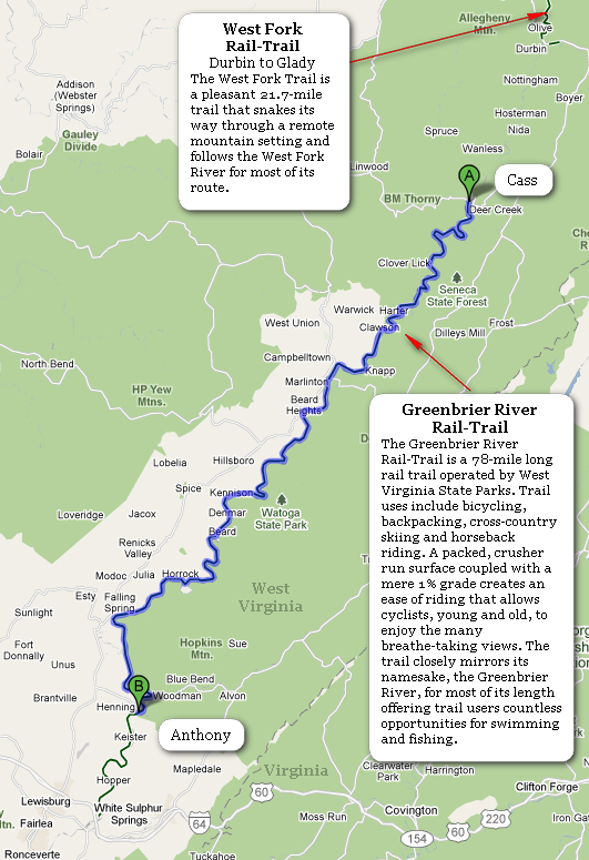
The Google map above will help give you an idea of where the GRRT is located. To the north is the
West Fork Rail-Trail which is part of the old rail corridor.
Nearly 10 years ago I rode the West Fork Rail-Trail with Laurel Klein of the
Country Roads Cyclists. There are photos of that ride
here.
~FINIS~