Manhattan
From Wikipedia, the free encyclopedia.
- For other uses, see Manhattan (disambiguation).
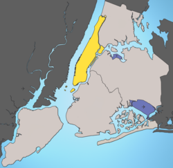
Manhattan refers both to the Island of Manhattan which borders the lower Hudson River, and also to the Borough of Manhattan (one of the five boroughs of New York City), which includes the Island of Manhattan itself, as well as several other smaller islands and a small portion of the mainland (see geography). The borough is conterminous with New York County, and addresses within the borough of Manhattan are typically designated as New York, New York. As of 2000, the population comprised 1,537,195 people, but the county is geographically among the smallest in the United States with only 33 square miles (85 km²) of land. Thus, it is by far the most densely populated county in both the state and the entire United States.
Contents |
History

The name Manhattan ("hilly island" or possibly "place of intoxication") is from the Algonquian languages of the earliest known inhabitants of the area. Legend has it that the island was purchased from the natives for $24 in beads and other such trinkets. Explorers however, paid the wrong tribe, who were glad to accept money for an island that wasn't even theirs. The first European discovery of Manhattan is generally credited to English explorer Henry Hudson sailing for the Dutch, who first entered Upper New York Bay on September 11, 1609, and sailing up the lower Hudson River, anchored off the tip of northern Manhattan that night. However, the earlier Italian explorer Giovanni da Verrazano explored New York harbor in 1524, and a few months later so did the Portuguese Estevan Gomez; the latter also recognized the Hudson River (calling it the Rio de San Antonio), and both, in all likelihood, saw Manhattan island while in New York Harbor.
The island was settled by the Dutch in 1613 as a fur trading post founded by Hendrick Christiansen; it must also be mentioned that Jan Rodrigues, the first African-American resident of New York, was among the first settlers. The original Dutch spelling of the island was Mannatthans. Later in 1623 it took the name of New Amsterdam. The Duke of York occupied it in 1664 and according to the Treaty of Breda ending the second Anglo-Dutch War of 1665 to 1667 it was offically recognised as English property (in exchange for the small island of Run in the East Indies).
New York County is named in honor of the Duke of York, later to become the Catholic James II of England, after whom the City and State of New York were also named. New York County was an original county of New York State, one of twelve created in 1683. At the time of creation of New York County, its territory consisted of Manhattan Island, and occupied the same area which it occupies today. In 1873, the western portion of the present Bronx County was transferred to New York County, and in 1895 the remainder of the present Bronx County was transferred to New York County. In 1898, when New York City was constituted as five boroughs, the separate boroughs of Manhattan and of the Bronx were formed, though both remained within the single County of New York. In 1914, those parts of the then New York County which had been annexed from Westchester County were constituted the new Bronx County, and New York County was reduced again to its present boundaries.
From the 1960s onwards Manhattan suffered from urban flight as the middle-class fled to the outer boroughs and suburbs due to an increase in crime. However, as with many other American cities, there was an increase in population growth in the latter part of the century due to a renewed interest in the urban lifestyle, a trend which began in the late 1980s and has continued to present day. It was thought that the September 11, 2001 attacks would initiate a new exodus from the City due to a fear of terrorism, but this has not come to pass.
Geography
The terms "New York County" and the "Borough of Manhattan" refer to the same geographical area, although in former times New York County also included part of today's Borough of The Bronx. As a part of New York City, New York County contains no other political subdivisions. It occupies the whole of Manhattan Island, surrounded by the East River, the Harlem River, and the Hudson River. It also includes some smaller islands, including Roosevelt Island (formerly Welfare Island, and even earlier Blackwell's Island), U Thant Island (officially known as Belmont Island), and a small portion of the North American mainland (Marble Hill) contiguous with The Bronx. Marble Hill was originally part of Manhattan Island; but the Harlem River Ship Canal, dug in the late 19th century to improve navigation on the Harlem River, separated it from the remainder of Manhattan, and eventually the part of the original Harlem River channel separating Marble Hill from the Bronx was filled in.
Manhattan Island is 21 km (13 miles) long and 3.7 km (2.3 miles) wide (at its widest point).
According to the United States Census Bureau, New York County (the Borough of Manhattan) has a total area of 87.5 km² (33.8 mi²). 59.5 km² (23.0 mi²) of it is land and 28.0 km² (10.8 mi²) of it is water. The total area is 32.01% water.
Manhattan is connected by bridges and tunnels to New Jersey to the west, and three New York City boroughs: the Bronx to the northeast and Brooklyn and Queens on Long Island to the east and south. Its only direct connection with the fifth New York City borough is the Staten Island Ferry, whose terminal is at Battery Park at its southern tip.
On May 28 and July 12 the sunset is aligned with the street grid lines, so that the sun is visible at or near the horizon from street level.
Manhattan landmarks

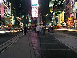
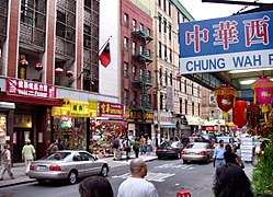
The Empire State Building, the theater district around Broadway, New York University, Columbia University, the financial center around Wall Street, Lincoln Center for the Performing Arts, Harlem, the American Museum of Natural History, Chinatown, and Central Park are all located on this densely populated island. The phrase "a New York minute" refers to the extremely rapid pace of living in Manhattan.
Fifth Avenue bisects Manhattan Island, dividing it into the East and West Sides. These east-west designations are used in latitudinal (east-west) streets (e.g. East 27th Street, West Houston Street). The Manhattan numbering system extends into the western Bronx, using Jerome Avenue as the east-west divider.
In Manhattan, uptown means north and downtown means south, either in direction of motion or in relative location. For example, an uptown train means a subway train heading north, while a restaurant located three blocks downtown would be three city blocks south of the person who is speaking. Beginning north of Houston Street, and fully in place north of 14th Street, nearly all east-west streets use numeric designations - which increase from south to north (reflecting the city's original growth in that direction). The terms uptown and downtown are most often used in the relative sense of north and south; however, uptown can also refer to the northern part of Manhattan (generally speaking, above 59th Street) and downtown to the southern part (typically, below 23rd Street or 14th Street). Keep in mind that these terms are relative - a resident of the Bronx would probably consider anything in Manhattan below 96th Street to be "downtown".
This usage differs from that of most American cities, where downtown refers to the central business district. Manhattan has two central business districts, namely the Financial District downtown and the newer business district in Midtown.
Within "downtown" is Lower Manhattan, a neighborhood defined as everything approximately south of Barclay Street and the Brooklyn Bridge; it is perhaps one of the most well-known parts of the city, home to City Hall, Wall Street, the South Street Seaport, the site of the former World Trade Center (often referred to commonly as "Ground Zero"), as well as a number of other significant landmarks.
The northernmost area of "uptown" is Upper Manhattan, encompassing the neighborhoods of Washington Heights and Inwood, and often Harlem. A less famous and hectic area, and given the distance from Midtown, Upper Manhattan is often thought of as an outer borough, given the similarities the region has to the adjacent western section of the South Bronx. In fact, Manhattan stretches so far northward from Midtown that some in the southern parts of Manhattan jokingly refer to the Inwood neighborhood as "Upstate Manhattan," "Arctic Manhattan," or "NoFair" (short for "North of Fairway," Fairway being a popular supermarket at 132nd St. and the Hudson River).
Traditionally, many New Yorkers have used the phrase The City when referring only to Manhattan, while referring to the other four boroughs as "outer boroughs". These terms are becoming less common, however, as more transplants from Manhattan continue to move into the other boroughs.
Neighborhoods

- Main article: List of Manhattan neighborhoods
Manhattan is politically divided in 12 Community Boards :
- 1 : Tribeca and Lower Manhattan
- 2 : Greenwich Village (aka West Village or simply "the Village"), NoHo, SoHo, Lower East Side, Chinatown, and Little Italy
- 3 : Tompkins Square, East Village, Lower East Side, Chinatown, Two Bridges
- 4 : Clinton, Chelsea
- 5 : Midtown
- 6 : Stuyvesant Town, Tudor City, Turtle Bay, Peter Cooper Village, Murray Hill, Gramercy Park, Kips Bay, and Sutton Place
- 7 : Manhattan Valley, Upper West Side, and Lincoln Square
- 8 : Upper East Side, LenoxHill, Yorkville, and Roosevelt Island
- 9 : Hamilton Heights, Manhattanville, and Morningside Heights
- 10 : Harlem and Polo Grounds
- 11 : East Harlem, El Barrio/Spanish Harlem, Ward's and Randall's Island
- 12 : Inwood and Washington Heights
As with all large cities, Manhattan consists of many distinct neighborhoods, each with its own character.
Law, government, and politics
| Year | GOP | Dems |
|---|---|---|
| 2004 | 16.7% 107,405 | 82.1% 526,765 |
| 2000 | 14.2% 79,921 | 79.8% 449,300 |
| 1996 | 13.8% 67,839 | 80.0% 394,131 |
| 1992 | 15.9% 84,501 | 78.2% 416,142 |
| 1988 | 22.9% 115,927 | 76.1% 385,675 |
| 1984 | 27.4% 144,281 | 72.1% 379,521 |
| 1980 | 26.2% 115,911 | 62.4% 275,742 |
| 1976 | 25.5% 117,702 | 73.2% 337,438 |
| 1972 | 33.4% 178,515 | 66.2% 354,326 |
| 1968 | 25.6% 135,458 | 70.0% 370,806 |
| 1964 | 19.2% 120,125 | 80.5% 503,848 |
| 1960 | 34.2% 217,271 | 65.3% 414,902 |
- See also: Government of New York City
Like the other counties which are contained within New York City, there is no county government, but county courts and some others such as the district attorney (public prosecutor) do exist. Each borough within New York City elects a borough president - Manhattan's borough president is currently Democrat C. Virginia Fields - but the office no longer carries any significant powers.
Manhattan is officially designated as the county seat of New York County.6 This is meaningless for all practical purposes because there are no other towns or cities in New York County, which is wholly contained within the City of New York. However, the Borough President's office, City Hall, the District Attorney's office, and the Municipal Building all cluster, within a few blocks of each other, near Center Street and the entrance to the Brooklyn Bridge - a downtown neighborhood.
Manhattan is one of the main strongholds of the Democratic party, and has never voted for a Republican in a Presidential election. The GOP used to win more than 20% of the vote, but it hasn't won even that much since before the Clinton era. Moreover, Republican registered voters are a very tiny minority in the borough, making more than 20% of the electorate only in the Upper East Side and Financial District.
Demographics
|
|
New York County is the most densely populated state county in the United States, with a density of 25,849.9/km². In 1910, it reached a peak to 46,428.9/km².
As of the census2 of 2000, there are 1,537,195 people, 738,644 households, and 302,105 families residing in the county. The population density is 25,849.9/km² (66,940.1/mi²). There are 798,144 housing units at an average density of 13,421.8/km² (34,756.7/mi²). The racial makeup of the county is 54.36% White, 27.18% of the population are Hispanic or Latino of any race, 17.39% Black or African American, 0.50% Native American, 9.40% Asian, 0.07% Pacific Islander, 14.14% other races, and 4.14% from two or more races.
A partial list of the specific European ancestry claimed by Manhattan residents is as follows (2000):
According to an estimation by the Census Bureau, the population of New York county increased to 1,562,723 in 2004. Lower Manhattan (ie Manhattan south of Houston street) has a sharply different population than the rest of the borough. Indeed, to the census of 2000, the neighborhood was 41 percent Asian, 32 percent non-Hispanic white, 19 percent Hispanic and 6 percent black, and 43 percent of the inhabitants were immigrants. This can be explained by the demographic weight of Chinatown, which counts for 55% of the population of Lower Manhattan.
There are 738,644 households out of which 17.1% have children under the age of 18 living with them, 25.2% are married couples living together, 12.6% have a female householder with no husband present, and 59.1% are non-families. 48.0% of all households are made up of individuals and 10.9% have someone living alone who is 65 years of age or older. The average household size is 2.00 and the average family size is 2.99.
In the county the population is spread out with 16.8% under the age of 18, 10.2% from 18 to 24, 38.3% from 25 to 44, 22.6% from 45 to 64, and 12.2% who are 65 years of age or older. The median age is 36 years. For every 100 females there are 90.3 males. For every 100 females age 18 and over, there are 87.9 males.
The median income for a household in the county is $47,030, and the median income for a family is $50,229. Males have a median income of $51,856 versus $45,712 for females. The per capita income for the county is $42,922. 20.0% of the population and 17.6% of families are below the poverty line. Out of the total population, 31.8% of those under the age of 18 and 18.9% of those 65 and older are living below the poverty line.

See also
External links
- Our Lady of Mount Carmel Shrine
- Randall's Lost New York City
- Letter of 1626 stating that Manhattan Island had been purchased for the value of 60 guilders (PD)
- Map of Mannados or Manhattan in 1661 (PD)
- NYC MTA Transit Bus Map of Manhattan (PDF file)
- The Story of Manhattan, by Charles Hemstreet. 1901 publication from Project Gutenberg
- Photographs of Manhattan
- Forgotten New York
- New York City Walk
Maps, streets, and neighborhoods
- Maps and aerial photos
- Street map from Google Local or Yahoo! Maps
- Topographic map from TopoZone
- Aerial image or topographic map from TerraServer-USA
- Satellite image from Google Local or Microsoft Virtual Earth
- Interactive Manhattan Map
- 1729 map of Manhattan


